Salles-sur-Garonne (Salles-sur-Garonne)

- commune in Haute-Garonne, France
- Country:

- Postal Code: 31390
- Coordinates: 43° 16' 22" N, 1° 10' 47" E


- GPS tracks (wikiloc): [Link]
- Area: 5.68 sq km
- Population: 552
- Web site: http://www.salles-sur-garonne.fr
- Wikipedia en: wiki(en)
- Wikipedia: wiki(fr)
- Wikidata storage: Wikidata: Q602349
- Wikipedia Commons Category: [Link]
- Freebase ID: [/m/03nq3gf]
- Freebase ID: [/m/03nq3gf]
- GeoNames ID: Alt: [6431835]
- GeoNames ID: Alt: [6431835]
- SIREN number: [213105257]
- SIREN number: [213105257]
- BnF ID: [15255520f]
- BnF ID: [15255520f]
- INSEE municipality code: 31525
- INSEE municipality code: 31525
Shares border with regions:

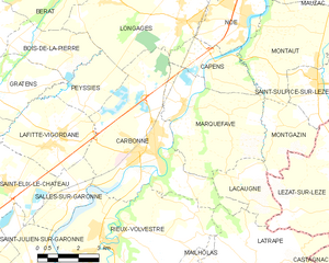
Carbonne
- commune in Haute-Garonne, France
- Country:
- Postal Code: 31390
- Coordinates: 43° 17' 50" N, 1° 13' 9" E
- GPS tracks (wikiloc): [Link]
- Area: 26.59 sq km
- Population: 5502
- Web site: [Link]


Lafitte-Vigordane
- commune in Haute-Garonne, France
- Country:
- Postal Code: 31390
- Coordinates: 43° 17' 59" N, 1° 9' 47" E
- GPS tracks (wikiloc): [Link]
- AboveSeaLevel: 227 м m
- Area: 11.38 sq km
- Population: 1140
- Web site: [Link]

Saint-Élix-le-Château
- commune in Haute-Garonne, France
- Country:
- Postal Code: 31430
- Coordinates: 43° 16' 46" N, 1° 8' 19" E
- GPS tracks (wikiloc): [Link]
- Area: 10.52 sq km
- Population: 854
- Web site: [Link]

Rieux-Volvestre
- commune in Haute-Garonne, France
- Country:
- Postal Code: 31310
- Coordinates: 43° 15' 27" N, 1° 11' 49" E
- GPS tracks (wikiloc): [Link]
- Area: 32.38 sq km
- Population: 2570
- Web site: [Link]
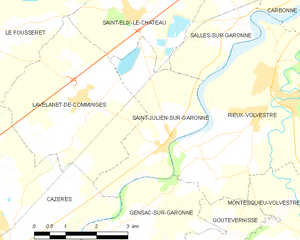
Saint-Julien-sur-Garonne
- commune in Haute-Garonne, France
- Country:
- Postal Code: 31220
- Coordinates: 43° 14' 33" N, 1° 9' 8" E
- GPS tracks (wikiloc): [Link]
- Area: 8.15 sq km
- Population: 539
- Web site: [Link]