
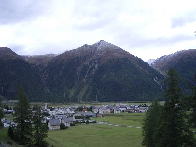
Samedan (Samedan)

- municipality in Switzerland
 Hiking in Samedan
Samedan, located in the Engadin Valley of Switzerland, is a beautiful destination for hiking enthusiasts. The region offers a mix of stunning landscapes, picturesque villages, and a range of trails suited for different skill levels. Here are some highlights of hiking in Samedan:
Trail Options:
-
Samedan - Muottas Muragl: A popular hike that combines scenic views with a manageable path. This trail offers incredible panoramas of the surrounding mountains and valleys.
-
Margna Trail: This trail is known for its serene environment and beautiful views. It offers a perfect mix of meadows, forests, and alpine lakes.
-
Val Bever: This stunning valley features several trails, ranging from easy walks to more challenging hikes. You can explore charming villages and pristine nature.
-
Engadin Valley Trail: This long-distance trail connects various villages in the Engadin region and showcases the stunning beauty of the area. Portions of it can be accessed from Samedan.
Difficulty Levels:
- Easy: There are flat and well-marked trails ideal for families and beginners.
- Moderate: Hikes that offer a bit of elevation gain and stunning views.
- Challenging: More difficult routes that may require proper gear and experience.
Best Time to Hike:
- Summer (June to September): This is the peak hiking season when trails are generally clear of snow, and the weather is warm.
- Autumn (October): Offers beautiful fall colors and fewer crowds, but check trail conditions as snow can arrive earlier at higher elevations.
Tips for Hiking in Samedan:
- Gear Up: Wear appropriate hiking footwear and carry layers for variable weather.
- Hydrate: Carry sufficient water, especially during longer hikes.
- Navigation: Use a map or a hiking app for navigation, as some trails may not be well-marked.
- Local Information: Stop by the local tourism office for trail maps and advice on current conditions.
- Respect Nature: Keep to marked trails and adhere to local guidelines to preserve the fragile alpine environment.
Whether you are looking for a leisurely stroll or a challenging trek, Samedan provides a wonderful backdrop for hiking adventures in the Swiss Alps!
- Country:

- Postal Code: 7503
- Local Dialing Code: 081
- Licence Plate Code: GR
- Coordinates: 46° 32' 1" N, 9° 52' 19" E


- GPS tracks (wikiloc): [Link]
- AboveSeaLevel: 2970 м m
- Area: 113.80 sq km
- Population: 2956
- Web site: http://www.samedan.ch
- Wikipedia en: wiki(en)
- Wikipedia: wiki(de)
- Wikidata storage: Wikidata: Q69085
- Wikipedia Commons Category: [Link]
- Freebase ID: [/m/0cwf0n]
- GeoNames ID: Alt: [7287048]
- VIAF ID: Alt: [239039396]
- OSM relation ID: [1684150]
- archINFORM location ID: [4037]
- MusicBrainz area ID: [413b2a5c-e8b3-45e5-974e-667b8e9b95a3]
- HDS ID: [1542]
- Swiss municipality code: [3786]
Shares border with regions:
Lanzada
- Italian comune
Hiking in Lanzada
Lanzada, located on the beautiful Galician coast in Spain, is known for its stunning beaches, picturesque landscapes, and vibrant natural surroundings, making it a great destination for hiking enthusiasts. Here’s an overview of what to expect when hiking in the Lanzada area:...
- Country:

- Postal Code: 23020
- Local Dialing Code: 0342
- Licence Plate Code: SO
- Coordinates: 46° 16' 0" N, 9° 52' 0" E
- GPS tracks (wikiloc): [Link]
- AboveSeaLevel: 1000 м m
- Area: 117.17 sq km
- Population: 1335
- Web site: [Link]


Sils im Engadin/Segl
- municipality in Switzerland
Hiking in Sils im Engadin/Segl
Sils im Engadin-Segli is a picturesque village located in the Engadine Valley of Switzerland, renowned for its stunning landscapes and excellent hiking opportunities. This area is part of the larger UNESCO World Heritage site of the Swiss Alps and offers a range of trails suitable for different skill levels....
- Country:
- Postal Code: 7514
- Local Dialing Code: 081
- Licence Plate Code: GR
- Coordinates: 46° 25' 59" N, 9° 45' 59" E
- GPS tracks (wikiloc): [Link]
- AboveSeaLevel: 1803 м m
- Area: 63.57 sq km
- Population: 691
- Web site: [Link]


Celerina/Schlarigna
- municipality in Switzerland
Hiking in Celerina/Schlarigna
Celerina-Schlarigna is a charming area located in the Engadin Valley in Switzerland, renowned for its breathtaking landscapes and outdoor recreational opportunities, particularly hiking. Here’s a comprehensive overview of hiking in this beautiful destination:...
- Country:
- Postal Code: 7505
- Local Dialing Code: 081
- Licence Plate Code: GR
- Coordinates: 46° 30' 34" N, 9° 50' 38" E
- GPS tracks (wikiloc): [Link]
- AboveSeaLevel: 2007 м m
- Area: 24.02 sq km
- Population: 1506
- Web site: [Link]


Silvaplana
- municipality in Switzerland
Hiking in Silvaplana
Silvaplana, located in the Engadin valley in Switzerland, is a beautiful destination for hiking enthusiasts. Nestled between the stunning lakes of Silvaplana and Sils, and surrounded by imposing mountain scenery, it offers a variety of hiking trails for all levels of experience....
- Country:
- Postal Code: 7513
- Local Dialing Code: 081
- Licence Plate Code: GR
- Coordinates: 46° 27' 29" N, 9° 47' 43" E
- GPS tracks (wikiloc): [Link]
- AboveSeaLevel: 1817 м m
- Area: 44.77 sq km
- Population: 1117
- Web site: [Link]


La Punt-Chamues-ch
- municipality in Switzerland
Hiking in La Punt-Chamues-ch
La Punt-Chamues-ch is a picturesque village located in the Engadin valley of Switzerland, known for its stunning landscapes, traditional architecture, and excellent hiking opportunities. Here are some key aspects to consider when hiking in this beautiful region:...
- Country:
- Postal Code: 7522
- Local Dialing Code: 081
- Licence Plate Code: GR
- Coordinates: 46° 33' 59" N, 9° 54' 59" E
- GPS tracks (wikiloc): [Link]
- AboveSeaLevel: 1687 м m
- Area: 63.27 sq km
- Population: 712
- Web site: [Link]


Bergün
- municipality in Switzerland
Hiking in Bergün
Bergün, located in the scenic Albula Valley in the Swiss canton of Graubünden, is a fantastic destination for hiking enthusiasts. The area offers a variety of trails that cater to different skill levels, making it suitable for families, casual hikers, and experienced trekkers alike. Here are some highlights of hiking in Bergün:...
- Country:
- Postal Code: 7482
- Local Dialing Code: 081
- Licence Plate Code: GR
- Coordinates: 46° 37' 26" N, 9° 47' 14" E
- GPS tracks (wikiloc): [Link]
- AboveSeaLevel: 1367 м m
- Area: 145.65 sq km
- Population: 480
- Web site: [Link]


St. Moritz
- resort town in the Engadine valley in Switzerland
Hiking in St. Moritz
St. Moritz, located in the Swiss Alps, is renowned for its stunning landscapes and offers incredible hiking opportunities for both novice and experienced hikers. The region is characterized by its picturesque lakes, majestic mountains, and lush valleys, making it an ideal destination for outdoor enthusiasts. Here are some highlights and tips for hiking in St. Moritz:...
- Country:
- Postal Code: 7500
- Local Dialing Code: 081
- Licence Plate Code: GR
- Coordinates: 46° 29' 51" N, 9° 50' 17" E
- GPS tracks (wikiloc): [Link]
- AboveSeaLevel: 1822 м m
- Area: 28.69 sq km
- Population: 4994
- Web site: [Link]

Bever
- municipality in Graubünden, Switzerland
Hiking in Bever
Bever, Switzerland, is a charming village located in the Engadin Valley and is part of the UNESCO Biosphere Reserve. It offers incredible hiking opportunities amidst stunning alpine scenery, making it an attractive destination for both novice and seasoned hikers. Here are some key details about hiking in Bever:...
- Country:
- Postal Code: 7502
- Local Dialing Code: 081
- Licence Plate Code: GR
- Coordinates: 46° 32' 59" N, 9° 52' 59" E
- GPS tracks (wikiloc): [Link]
- AboveSeaLevel: 2653 м m
- Area: 47.75 sq km
- Population: 598
- Web site: [Link]


Pontresina
- village in the Engadine valley, Graubünden, Switzerland
Hiking in Pontresina
Pontresina is a picturesque mountain village located in the Engadin valley of Switzerland, known for its stunning landscapes, diverse hiking trails, and proximity to the Bernina Range. Here are some key points about hiking in Pontresina:...
- Country:
- Postal Code: 7504
- Local Dialing Code: 081
- Licence Plate Code: GR
- Coordinates: 46° 26' 28" N, 9° 57' 27" E
- GPS tracks (wikiloc): [Link]
- AboveSeaLevel: 2446 м m
- Area: 118.19 sq km
- Population: 2195
- Web site: [Link]