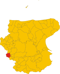
San Bartolomeo in Galdo (San Bartolomeo in Galdo)
.svg)
- Italian comune
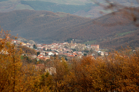
 Hiking in San Bartolomeo in Galdo
San Bartolomeo in Galdo, located in the Campania region of Italy, is a picturesque small town surrounded by beautiful natural landscapes, making it a great destination for hiking enthusiasts. The area features rolling hills, lush forests, and stunning views, providing numerous trails for various skill levels.
Popular Hiking Trails
-
Sentiero degli Dei (Path of the Gods): While this famous trail is a bit further out, it's worth the trip if you have the time. It offers breathtaking views of the Amalfi Coast and is suited for more experienced hikers.
-
Local Nature Trails: Within the vicinity of San Bartolomeo, there are various local trails that take you through dense beech and chestnut forests. These trails often lead to panoramic viewpoints, offering stunning vistas over the surrounding valleys.
-
Cultural Trails: Some shorter hikes combine nature with culture, leading you to nearby historical sites and offering insights into the local heritage, including old churches and traditional farms.
Tips for Hiking in San Bartolomeo in Galdo
- Weather Considerations: Check the weather before heading out, as conditions can change. Spring and early fall are generally the best times for hiking in this region.
- Equipment: Wear sturdy hiking boots for stability and comfort, and dress in layers to adjust to changing temperatures. Don't forget essentials like water, snacks, a map, and a first-aid kit.
- Local Guidelines: Respect local wildlife and plants, stick to marked trails to avoid damaging the ecosystem, and ensure you leave no trace behind.
Additional Activities
Besides hiking, you can explore the local culture by visiting traditional villages or enjoying regional cuisine. The area is known for its delicious local dishes and wines, making it a rewarding experience after a day on the trails.
San Bartolomeo in Galdo is an excellent location for a peaceful hike amid nature, making it ideal for both adventurers and those looking to enjoy a serene escape.
- Country:

- Postal Code: 82028
- Local Dialing Code: 0824
- Licence Plate Code: BN
- Coordinates: 41° 25' 0" N, 15° 1' 0" E


- GPS tracks (wikiloc): [Link]
- AboveSeaLevel: 597 м m
- Area: 82.67 sq km
- Population: 4743
- Web site: http://www.comune.sanbartolomeoingaldo.bn.it/
- Wikipedia en: wiki(en)
- Wikipedia: wiki(it)
- Wikidata storage: Wikidata: Q55954
- Wikipedia Commons Gallery: [Link]
- Wikipedia Commons Category: [Link]
- Freebase ID: [/m/0gn27p]
- GeoNames ID: Alt: [6541901]
- VIAF ID: Alt: [147029655]
- OSM relation ID: [41266]
- WOEID: [722333]
- UN/LOCODE: [ITGAD]
- ISTAT ID: 062057
- Italian cadastre code: H764
Shares border with regions:


Tufara
- Italian comune
Hiking in Tufara
Tufara is a less commonly known destination for hiking but offers some beautiful landscapes and experiences for nature enthusiasts. Located in the Abruzzo region of Italy, Tufara is surrounded by the Apennine Mountains, providing various trails that cater to different skill levels. Here are some highlights about hiking in the area:...
- Country:
- Postal Code: 86010
- Local Dialing Code: 0874
- Licence Plate Code: CB
- Coordinates: 41° 29' 0" N, 14° 57' 0" E
- GPS tracks (wikiloc): [Link]
- AboveSeaLevel: 420 м m
- Area: 35.52 sq km
- Population: 887
- Web site: [Link]
Alberona
- Italian comune
Hiking in Alberona
Alberona is a charming village located in the Apennine mountains of Italy, specifically in the region of Puglia. While it's less known compared to some major hiking destinations, the surrounding areas offer several beautiful trails and natural scenery, making it an appealing location for hiking enthusiasts. Here are some key points about hiking around Alberona:...
- Country:
- Postal Code: 71031
- Local Dialing Code: 0881
- Licence Plate Code: FG
- Coordinates: 41° 26' 0" N, 15° 7' 0" E
- GPS tracks (wikiloc): [Link]
- AboveSeaLevel: 732 м m
- Area: 49.75 sq km
- Population: 956
- Web site: [Link]

Roseto Valfortore
- Italian comune
Hiking in Roseto Valfortore
Roseto Valfortore is a picturesque village located in the Apennine Mountains of Italy, within the province of Foggia in the region of Puglia. Known for its stunning natural landscapes, historical buildings, and traditional culture, it offers a wonderful setting for hiking enthusiasts....
- Country:
- Postal Code: 71039
- Local Dialing Code: 0881
- Licence Plate Code: FG
- Coordinates: 41° 22' 32" N, 15° 5' 54" E
- GPS tracks (wikiloc): [Link]
- AboveSeaLevel: 650 м m
- Area: 50.06 sq km
- Population: 1075
- Web site: [Link]


San Marco la Catola
- Italian comune
Hiking in San Marco la Catola
San Marco la Catola is a charming town located in the Apulia region of Italy, known for its beautiful landscapes and natural surroundings, making it a great destination for hiking enthusiasts. Here are some highlights to consider if you're planning a hiking trip in the area:...
- Country:
- Postal Code: 71030
- Local Dialing Code: 0881
- Licence Plate Code: FG
- Coordinates: 41° 31' 30" N, 15° 0' 24" E
- GPS tracks (wikiloc): [Link]
- AboveSeaLevel: 686 м m
- Area: 28.63 sq km
- Population: 965
- Web site: [Link]


Volturara Appula
- Italian comune
Hiking in Volturara Appula
Volturara Appula is a quaint village located in the Apulia region of Italy, known for its beautiful landscapes and rich history. Hiking in and around Volturara Appula can offer a unique blend of natural beauty, cultural heritage, and adventure....
- Country:
- Postal Code: 71030
- Local Dialing Code: 0881
- Licence Plate Code: FG
- Coordinates: 41° 30' 0" N, 15° 3' 0" E
- GPS tracks (wikiloc): [Link]
- AboveSeaLevel: 510 м m
- Area: 52 sq km
- Population: 401
- Web site: [Link]
Baselice
- Italian comune
Hiking in Baselice
Baselice, a charming town located in the province of Benevento in the Campania region of Italy, offers a variety of hiking opportunities, particularly for those who enjoy exploring the picturesque landscapes of southern Italy....
- Country:
- Postal Code: 82020
- Local Dialing Code: 0824
- Licence Plate Code: BN
- Coordinates: 41° 24' 0" N, 14° 58' 0" E
- GPS tracks (wikiloc): [Link]
- AboveSeaLevel: 620 м m
- Area: 47.82 sq km
- Population: 2313
- Web site: [Link]


Castelvetere in Val Fortore
- Italian comune
Hiking in Castelvetere in Val Fortore
Castelvetere in Val Fortore is a picturesque town located in the Campania region of southern Italy. Nestled in the Apennine mountains, it offers a variety of hiking opportunities for outdoor enthusiasts. Here are some key points to consider if you plan to hike in this area:...
- Country:
- Postal Code: 82023
- Local Dialing Code: 0824
- Licence Plate Code: BN
- Coordinates: 41° 27' 0" N, 14° 56' 0" E
- GPS tracks (wikiloc): [Link]
- AboveSeaLevel: 706 м m
- Area: 34.58 sq km
- Population: 1165
- Web site: [Link]

Foiano di Val Fortore
- Italian comune
Hiking in Foiano di Val Fortore
Foiano di Val Fortore is a charming village located in the province of Benevento in the Campania region of Italy. Surrounded by the beautiful mountainous landscapes of the Apennine range, it offers various hiking opportunities for outdoor enthusiasts....
- Country:
- Postal Code: 82020
- Local Dialing Code: 0824
- Licence Plate Code: BN
- Coordinates: 41° 21' 0" N, 14° 59' 0" E
- GPS tracks (wikiloc): [Link]
- AboveSeaLevel: 520 м m
- Area: 41.31 sq km
- Population: 1403
- Web site: [Link]