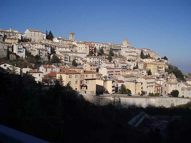
San Lorenzo in Campo (San Lorenzo in Campo)
.svg)
- Italian comune
 Hiking in San Lorenzo in Campo
San Lorenzo in Campo is a charming town located in the Marche region of Italy, known for its beautiful landscapes, rich history, and outdoor activities, including hiking. The surrounding area offers a variety of trails suitable for different skill levels, allowing hikers to explore the natural beauty of the region.
Key Aspects of Hiking in San Lorenzo in Campo:
-
Scenic Trails: The region is characterized by rolling hills, forests, and agricultural landscapes. Trails often offer stunning views of the surrounding countryside and nearby mountains.
-
Difficulty Levels: There are trails available for all levels of hikers, from leisurely walks suitable for families to more challenging routes for experienced hikers. Be sure to choose a trail that matches your fitness level and experience.
-
Nature and Wildlife: As you hike, you'll have the opportunity to encounter diverse flora and fauna native to the Marche region. Keep an eye out for various bird species, as well as wildflowers and other plant life.
-
Historical Sites: Some trails may lead you to historical sites, such as ancient churches or remnants of old fortifications. Exploring these sites can add a cultural dimension to your hike.
-
Local Guidance: Consider seeking the assistance of local hiking guides or joining organized hiking groups. This can enhance your experience by providing insight into the area's history, geology, and ecology.
-
Best Time to Hike: The best seasons for hiking in this area are spring (April to June) and fall (September to October), when temperatures are mild and the landscapes are particularly beautiful.
-
Preparation: Always wear proper hiking footwear, carry sufficient water and snacks, and have a map or a GPS device to navigate the trails. Depending on the season, prepare for changing weather conditions.
-
Respect Nature: Follow the Leave No Trace principles to ensure that the environment remains pristine for future hikers. Stay on marked trails and take care to respect wildlife and plant life along the way.
If you're planning a hiking trip to San Lorenzo in Campo, do some research ahead of time on specific trails and consider local resources such as visitor centers or hiking clubs to make the most of your visit!
- Country:

- Postal Code: 61047
- Local Dialing Code: 0721
- Licence Plate Code: PU
- Coordinates: 43° 36' 18" N, 12° 56' 46" E


- GPS tracks (wikiloc): [Link]
- AboveSeaLevel: 209 м m
- Area: 28.8 sq km
- Population: 3358
- Web site: http://www.comune.sanlorenzoincampo.pu.it/
- Wikipedia en: wiki(en)
- Wikipedia: wiki(it)
- Wikidata storage: Wikidata: Q207568
- Wikipedia Commons Gallery: [Link]
- Wikipedia Commons Category: [Link]
- Freebase ID: [/m/0gl53g]
- GeoNames ID: Alt: [6541053]
- VIAF ID: Alt: [89124376]
- OSM relation ID: [42530]
- WOEID: [722767]
- UN/LOCODE: [ITSZ3]
- ISTAT ID: 041054
- Italian cadastre code: H958
Shares border with regions:

Arcevia
- Italian comune
Hiking in Arcevia
Arcevia, located in the Marche region of Italy, is an excellent destination for hiking enthusiasts. The area is renowned for its beautiful landscapes, medieval villages, and rich history. Here are some key points to consider if you're planning a hiking adventure in Arcevia:...
- Country:
- Postal Code: 60011
- Local Dialing Code: 0731
- Licence Plate Code: AN
- Coordinates: 43° 29' 0" N, 12° 56' 23" E
- GPS tracks (wikiloc): [Link]
- AboveSeaLevel: 535 м m
- Area: 128.33 sq km
- Population: 4496
- Web site: [Link]


Castelleone di Suasa
- Italian comune
Hiking in Castelleone di Suasa
Castelleone di Suasa is a charming town in the Marche region of Italy, located within a picturesque countryside that is ideal for hiking enthusiasts. The area is known for its rolling hills, rich history, and stunning natural landscapes, making it a great destination for outdoor activities, including hiking....
- Country:
- Postal Code: 60010
- Local Dialing Code: 071
- Licence Plate Code: AN
- Coordinates: 43° 36' 27" N, 12° 58' 35" E
- GPS tracks (wikiloc): [Link]
- AboveSeaLevel: 206 м m
- Area: 15.92 sq km
- Population: 1605
- Web site: [Link]


Corinaldo
- Italian comune
Hiking in Corinaldo
Corinaldo, a charming medieval town located in the Marche region of Italy, offers unique hiking opportunities that combine natural beauty with historical exploration. Here are some highlights and tips for hiking in and around Corinaldo:...
- Country:
- Postal Code: 60013
- Local Dialing Code: 071
- Licence Plate Code: AN
- Coordinates: 43° 38' 56" N, 13° 2' 52" E
- GPS tracks (wikiloc): [Link]
- AboveSeaLevel: 203 м m
- Area: 49.28 sq km
- Population: 4949
- Web site: [Link]


Fratte Rosa
- comune of Italy
Hiking in Fratte Rosa
Fratte Rosa is a charming village located in the Marche region of Italy, surrounded by beautiful landscapes and rolling hills that provide a wonderful backdrop for hiking enthusiasts. The area is known for its picturesque scenery, rich cultural heritage, and outdoor activities....
- Country:
- Postal Code: 61040
- Local Dialing Code: 0721
- Licence Plate Code: PU
- Coordinates: 43° 37' 56" N, 12° 54' 4" E
- GPS tracks (wikiloc): [Link]
- AboveSeaLevel: 419 м m
- Area: 15.63 sq km
- Population: 954
- Web site: [Link]

Mondavio
- Italian comune
Hiking in Mondavio
Mondavio is a charming town located in the Marche region of Italy, known for its historical architecture and beautiful landscapes. Hiking in and around Mondavio offers a unique opportunity to immerse yourself in the natural beauty of the Italian countryside while also experiencing local culture and history....
- Country:
- Postal Code: 61040
- Local Dialing Code: 0721
- Licence Plate Code: PU
- Coordinates: 43° 40' 27" N, 12° 58' 6" E
- GPS tracks (wikiloc): [Link]
- AboveSeaLevel: 280 м m
- Area: 29.64 sq km
- Population: 3830
- Web site: [Link]


Pergola, Marche
- Italian comune
Hiking in Pergola, Marche
Pergola, located in the Marche region of Italy, is a charming town nestled in the rolling hills and surrounded by beautiful landscapes, making it an excellent destination for hiking enthusiasts. Here are some highlights about hiking in the area:...
- Country:
- Postal Code: 61045
- Local Dialing Code: 0721
- Licence Plate Code: PU
- Coordinates: 43° 33' 51" N, 12° 50' 5" E
- GPS tracks (wikiloc): [Link]
- AboveSeaLevel: 265 м m
- Area: 112.4 sq km
- Population: 6200
- Web site: [Link]