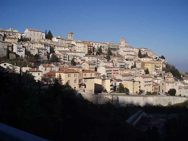
Pergola, Marche (Pergola)

- Italian comune
 Hiking in Pergola, Marche
Pergola, located in the Marche region of Italy, is a charming town nestled in the rolling hills and surrounded by beautiful landscapes, making it an excellent destination for hiking enthusiasts. Here are some highlights about hiking in the area:
Natural Beauty
- Scenic Views: The trails around Pergola offer stunning vistas of the surrounding countryside, including verdant hills, vineyards, and picturesque valleys.
- Diverse Terrain: The region is characterized by a mix of woodlands, fields, and hills, providing a variety of landscapes to explore.
Hiking Trails
- Sentiero dei Fossi: This trail takes you through the lush areas around Pergola, featuring quaint rivers and rich vegetation. It’s a great option for those looking for a moderate hike.
- Monte Catria: Slightly further afield, Monte Catria offers trails with varying difficulty levels and the chance to reach higher elevations with panoramic views. It is part of the larger Monte Catria and Cesane Regional Park.
- Nature Reserves: Explore nearby natural reserves like the Gola del Furlo, where you can find well-marked trails alongside the Furlo Gorge, famous for its stunning rock formations and diverse wildlife.
Cultural Experiences
- Historical Sites: Along the trails, you may encounter ancient villages, churches, and monuments, allowing you to combine hiking with cultural exploration.
- Local Cuisine: After a day of hiking, enjoy the local Marche cuisine in Pergola or nearby towns, famous for its rich flavors and regional specialties.
Tips for Hiking in Pergola
- Best Time to Hike: Spring and early autumn are ideal for hiking, with moderate temperatures and beautiful scenery. Summer can be hot, and winter may lead to snow in higher elevations.
- Trail Maps: Bring a detailed map or use a hiking app to navigate the trails, as some may not be well-marked.
- Local Guide: Consider hiring a local guide for a more enriching experience, especially if you're unfamiliar with the area or prefer to explore off the beaten path.
Overall, Pergola offers a combination of natural beauty, cultural richness, and excellent hiking opportunities, making it a great destination for both casual walkers and seasoned hikers.
- Country:

- Postal Code: 61045
- Local Dialing Code: 0721
- Licence Plate Code: PU
- Coordinates: 43° 33' 51" N, 12° 50' 5" E


- GPS tracks (wikiloc): [Link]
- AboveSeaLevel: 265 м m
- Area: 112.4 sq km
- Population: 6200
- Web site: http://www.comune.pergola.pu.it/
- Wikipedia en: wiki(en)
- Wikipedia: wiki(it)
- Wikidata storage: Wikidata: Q207463
- Wikipedia Commons Gallery: [Link]
- Wikipedia Commons Category: [Link]
- Freebase ID: [/m/02pk2fb]
- GeoNames ID: Alt: [6540446]
- OSM relation ID: [42494]
- archINFORM location ID: [6998]
- MusicBrainz area ID: [2c9400bb-b10f-4e53-b80e-d3d50f64089d]
- UN/LOCODE: [ITZPK]
- ISTAT ID: 041043
- Italian cadastre code: G453
Shares border with regions:

Arcevia
- Italian comune
Hiking in Arcevia
Arcevia, located in the Marche region of Italy, is an excellent destination for hiking enthusiasts. The area is renowned for its beautiful landscapes, medieval villages, and rich history. Here are some key points to consider if you're planning a hiking adventure in Arcevia:...
- Country:
- Postal Code: 60011
- Local Dialing Code: 0731
- Licence Plate Code: AN
- Coordinates: 43° 29' 0" N, 12° 56' 23" E
- GPS tracks (wikiloc): [Link]
- AboveSeaLevel: 535 м m
- Area: 128.33 sq km
- Population: 4496
- Web site: [Link]


Sassoferrato
- Italian comune
Hiking in Sassoferrato
Sassoferrato, located in the Marche region of Italy, is a fantastic destination for hiking enthusiasts. The area is characterized by its stunning natural landscapes, rich history, and diverse trails that cater to a variety of skill levels. Here are some key highlights about hiking in Sassoferrato:...
- Country:
- Postal Code: 60041
- Local Dialing Code: 0732
- Licence Plate Code: AN
- Coordinates: 43° 25' 39" N, 12° 51' 23" E
- GPS tracks (wikiloc): [Link]
- AboveSeaLevel: 386 м m
- Area: 137.23 sq km
- Population: 7104
- Web site: [Link]

Cagli
- Italian comune
Hiking in Cagli
Cagli, a charming town in the Marche region of Italy, is surrounded by beautiful natural landscapes, making it a great destination for hiking enthusiasts. The area is characterized by rolling hills, lush forests, and scenic views that are perfect for both novice and experienced hikers....
- Country:
- Postal Code: 61043
- Local Dialing Code: 0721
- Licence Plate Code: PU
- Coordinates: 43° 32' 49" N, 12° 38' 50" E
- GPS tracks (wikiloc): [Link]
- AboveSeaLevel: 276 м m
- Area: 226.46 sq km
- Population: 8546
- Web site: [Link]


Fossombrone
- Italian comune
Hiking in Fossombrone
Fossombrone, located in the Marche region of Italy, is a great destination for hiking enthusiasts. Nestled in the Cesano River valley and surrounded by the beautiful Apennine mountains, Fossombrone offers a variety of trails suitable for different skill levels, showcasing stunning landscapes, rich biodiversity, and historic sites....
- Country:
- Postal Code: 61034
- Local Dialing Code: 0721
- Licence Plate Code: PU
- Coordinates: 43° 41' 20" N, 12° 48' 22" E
- GPS tracks (wikiloc): [Link]
- AboveSeaLevel: 118 м m
- Area: 106.88 sq km
- Population: 9454
- Web site: [Link]


Fratte Rosa
- comune of Italy
Hiking in Fratte Rosa
Fratte Rosa is a charming village located in the Marche region of Italy, surrounded by beautiful landscapes and rolling hills that provide a wonderful backdrop for hiking enthusiasts. The area is known for its picturesque scenery, rich cultural heritage, and outdoor activities....
- Country:
- Postal Code: 61040
- Local Dialing Code: 0721
- Licence Plate Code: PU
- Coordinates: 43° 37' 56" N, 12° 54' 4" E
- GPS tracks (wikiloc): [Link]
- AboveSeaLevel: 419 м m
- Area: 15.63 sq km
- Population: 954
- Web site: [Link]


Frontone
- Italian comune
Hiking in Frontone
Frontone, a charming village in the Marche region of Italy, offers a variety of hiking opportunities for enthusiasts of all levels. Nestled in the Apennine Mountains, it boasts stunning landscapes, rich history, and breathtaking views....
- Country:
- Postal Code: 61040
- Local Dialing Code: 0721
- Licence Plate Code: PU
- Coordinates: 43° 30' 52" N, 12° 44' 18" E
- GPS tracks (wikiloc): [Link]
- AboveSeaLevel: 412 м m
- Area: 36.08 sq km
- Population: 1293
- Web site: [Link]


San Lorenzo in Campo
- Italian comune
Hiking in San Lorenzo in Campo
San Lorenzo in Campo is a charming town located in the Marche region of Italy, known for its beautiful landscapes, rich history, and outdoor activities, including hiking. The surrounding area offers a variety of trails suitable for different skill levels, allowing hikers to explore the natural beauty of the region....
- Country:
- Postal Code: 61047
- Local Dialing Code: 0721
- Licence Plate Code: PU
- Coordinates: 43° 36' 18" N, 12° 56' 46" E
- GPS tracks (wikiloc): [Link]
- AboveSeaLevel: 209 м m
- Area: 28.8 sq km
- Population: 3358
- Web site: [Link]


Serra Sant'Abbondio
- Italian comune
Hiking in Serra Sant'Abbondio
Serra Sant'Abbondio is a beautiful area located in the Marche region of Italy, known for its stunning landscapes, rich natural diversity, and charming villages. When it comes to hiking in this region, there are plenty of trails that cater to various skill levels, offering both easy walks and more challenging hikes....
- Country:
- Postal Code: 61040
- Local Dialing Code: 0721
- Licence Plate Code: PU
- Coordinates: 43° 29' 27" N, 12° 46' 14" E
- GPS tracks (wikiloc): [Link]
- AboveSeaLevel: 523 м m
- Area: 32.8 sq km
- Population: 1001
- Web site: [Link]