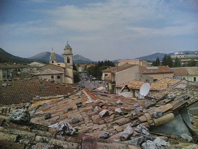
San Polo Matese (San Polo Matese)
.svg)
- Italian comune
 Hiking in San Polo Matese
San Polo Matese, located in the Campania region of Italy, offers beautiful hiking opportunities, particularly in the area of the Matese Massif. This mountain range is characterized by its stunning landscapes, rich biodiversity, and a variety of trails suited for different skill levels.
Key Highlights for Hiking in San Polo Matese:
-
Scenic Trails: The area features a network of well-marked hiking trails. One popular route is the trail leading to the summit of Monte Miletto, which provides breathtaking panoramic views of the surrounding mountains and valleys.
-
Natural Beauty: Hikers can enjoy diverse landscapes, including lush forests, meadows, and rocky outcrops. The region is also home to a rich variety of flora and fauna, with opportunities to spot local wildlife.
-
Historical Landmarks: Along the trails, you may encounter historic sites such as old monasteries and villages, adding a cultural dimension to your hiking experience.
-
Wildlife Watching: The Matese area is known for its wildlife, including deer, wolves, and numerous bird species. Bring binoculars for an enhanced viewing experience.
-
Local Cuisine: After a day of hiking, indulge in local Campanian cuisine at nearby restaurants. Don't miss trying regional specialties, including cheeses, cured meats, and homemade pasta.
Hiking Tips:
- Stay Hydrated: Always carry enough water, especially on warmer days.
- Dress Appropriately: Wear comfortable hiking shoes and dress in layers, as weather conditions can change rapidly in the mountains.
- Trail Maps and Navigation: Make sure to have a map or a GPS device, as some trails may not be well-signed. It's also a good idea to inform someone about your hiking plans.
- Respect Nature: Follow Leave No Trace principles by minimizing your impact on the environment.
Best Time to Hike:
- The ideal months for hiking in the San Polo Matese area are typically from late spring (May) to early autumn (October) when the weather is pleasant, and the trails are more accessible.
For those who enjoy exploring the great outdoors, hiking in San Polo Matese can be a rewarding experience filled with natural beauty and tranquility.
- Country:

- Postal Code: 86020
- Local Dialing Code: 0874
- Licence Plate Code: CB
- Coordinates: 41° 28' 0" N, 14° 30' 0" E


- GPS tracks (wikiloc): [Link]
- AboveSeaLevel: 730 м m
- Area: 15.28 sq km
- Population: 483
- Web site: http://www.sanpolomatese.eu/
- Wikipedia en: wiki(en)
- Wikipedia: wiki(it)
- Wikidata storage: Wikidata: Q278188
- Wikipedia Commons Category: [Link]
- Freebase ID: [/m/0gnpwk]
- GeoNames ID: Alt: [6537526]
- OSM relation ID: [41298]
- UN/LOCODE: [ITPMT]
- ISTAT ID: 070071
- Italian cadastre code: I122
Shares border with regions:

Bojano
- Italian comune
Hiking in Bojano
Bojano, located in the Molise region of Italy, offers a unique blend of natural beauty, rich history, and local culture, making it a worthwhile destination for hiking enthusiasts. Here are some highlights for hiking in and around Bojano:...
- Country:
- Postal Code: 86021
- Local Dialing Code: 0874
- Licence Plate Code: CB
- Coordinates: 41° 29' 0" N, 14° 28' 0" E
- GPS tracks (wikiloc): [Link]
- AboveSeaLevel: 480 м m
- Area: 52.63 sq km
- Population: 8178
- Web site: [Link]
Campochiaro
- Italian comune
Hiking in Campochiaro
Campochiaro is a picturesque village located in the Molise region of Italy, known for its beautiful landscapes and outdoor activities, including hiking. The area offers a range of trails that showcase the natural beauty of the Apennine Mountains, with diverse terrain and varying levels of difficulty suitable for hikers of all experiences....
- Country:
- Postal Code: 86020
- Local Dialing Code: 0874
- Licence Plate Code: CB
- Coordinates: 41° 27' 0" N, 14° 31' 0" E
- GPS tracks (wikiloc): [Link]
- AboveSeaLevel: 750 м m
- Area: 35.7 sq km
- Population: 635
- Web site: [Link]
Colle d'Anchise
- Italian comune
Hiking in Colle d'Anchise
Colle d'Anchise, located in the Molise region of Italy, primarily offers a serene and picturesque hiking experience. Here’s what you need to know if you’re considering a hiking trip there:...
- Country:
- Postal Code: 86020
- Local Dialing Code: 0874
- Licence Plate Code: CB
- Coordinates: 41° 31' 0" N, 14° 31' 0" E
- GPS tracks (wikiloc): [Link]
- AboveSeaLevel: 649 м m
- Area: 15.69 sq km
- Population: 791
- Web site: [Link]

San Gregorio Matese
- Italian comune
Hiking in San Gregorio Matese
San Gregorio Matese is a picturesque village located in the Campania region of Italy, nestled in the Matese mountain range. This area is known for its stunning natural beauty, offering a variety of hiking opportunities that cater to different skill levels. Here are some highlights and recommendations for hiking in San Gregorio Matese:...
- Country:
- Postal Code: 81010
- Local Dialing Code: 0823
- Licence Plate Code: CE
- Coordinates: 41° 23' 0" N, 14° 22' 0" E
- GPS tracks (wikiloc): [Link]
- AboveSeaLevel: 765 м m
- Area: 56.51 sq km
- Population: 946
- Web site: [Link]