
San Romano in Garfagnana (San Romano in Garfagnana)
.svg)
- Italian comune
 Hiking in San Romano in Garfagnana
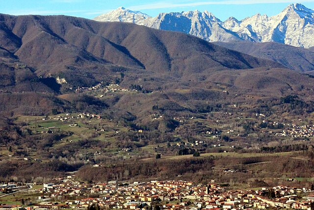
San Romano in Garfagnana is a picturesque village located in the Garfagnana region of Tuscany, Italy. This area is known for its stunning natural beauty, rugged landscapes, and rich cultural heritage, making it a fantastic destination for hiking enthusiasts.
Hiking Opportunities:
-
Diverse Trails: San Romano is surrounded by a variety of trails that cater to different skill levels, from gentle walks suitable for families to more challenging hikes for seasoned trekkers. The paths often lead through lush forests, along rivers, and to panoramic viewpoints.
-
Parco Nazionale Appennino Tosco-Emiliano: Just a short distance from San Romano, this national park offers numerous trails with breathtaking views of the Apennines. You'll find well-marked trails that showcase the area's rich biodiversity and scenic landscapes.
-
Cultural Pathways: Many hikes in and around San Romano lead to historical sites, such as ancient churches and castles. Exploring these routes provides insight into the local culture and history.
-
Wildlife Watching: The area is rich in wildlife, making it an excellent spot for birdwatchers and nature enthusiasts. Keep an eye out for local fauna as you hike through different habitats.
Best Times to Hike:
- Spring and Fall: These seasons offer milder weather and colorful landscapes, making them ideal for hiking. The wildflowers bloom in spring, and the foliage transforms in the fall, creating stunning scenery.
- Summer: While summer is popular for hiking, keep in mind that temperatures can rise. Early morning hikes are best to avoid the heat of the day.
Preparation and Tips:
- Proper Gear: Wear sturdy hiking boots, and dress in layers to adjust to changing temperatures during your hike. A backpack with water, snacks, and a first aid kit is essential.
- Maps and Guides: While some trails are well-marked, it's wise to carry a map or a GPS device. Local hiking guides or apps can provide additional support.
- Respect Nature: Follow the Leave No Trace principles to maintain the beauty of the environment and protect local wildlife.
Overall, hiking in San Romano in Garfagnana offers a perfect blend of outdoor adventure and scenic beauty, making it a rewarding experience for all who explore its trails.
- Country:

- Postal Code: 55038
- Local Dialing Code: 0583
- Licence Plate Code: LU
- Coordinates: 44° 10' 0" N, 10° 21' 0" E


- GPS tracks (wikiloc): [Link]
- AboveSeaLevel: 555 м m
- Area: 26.16 sq km
- Population: 1408
- Web site: http://www.comune.san-romano-in-garfagnana.lu.it
- Wikipedia en: wiki(en)
- Wikipedia: wiki(it)
- Wikidata storage: Wikidata: Q219641
- Wikipedia Commons Category: [Link]
- Freebase ID: [/m/0glbc8]
- GeoNames ID: Alt: [6542720]
- VIAF ID: Alt: [249411390]
- OSM relation ID: [42905]
- GND ID: Alt: [4705228-4]
- ISTAT ID: 046027
- Italian cadastre code: I142
Shares border with regions:


Camporgiano
- Italian comune
Hiking in Camporgiano
Camporgiano is a charming village located in the Garfagnana region of Tuscany, Italy. This area is known for its stunning landscapes, including valleys, mountains, and rich natural flora and fauna, making it an excellent destination for hiking enthusiasts....
- Country:
- Postal Code: 55031
- Local Dialing Code: 0583
- Licence Plate Code: LU
- Coordinates: 44° 9' 39" N, 10° 20' 4" E
- GPS tracks (wikiloc): [Link]
- AboveSeaLevel: 475 м m
- Area: 27.09 sq km
- Population: 2137
- Web site: [Link]


Piazza al Serchio
- Italian comune
Hiking in Piazza al Serchio
Piazza al Serchio is a charming village located in the Garfagnana region of Tuscany, Italy. It's known for its stunning natural landscapes, rich history, and access to beautiful hiking trails that cater to various skill levels. Here are some highlights for hiking in the area:...
- Country:
- Postal Code: 55035
- Local Dialing Code: 0583
- Licence Plate Code: LU
- Coordinates: 44° 11' 0" N, 10° 18' 0" E
- GPS tracks (wikiloc): [Link]
- AboveSeaLevel: 536 м m
- Area: 27.03 sq km
- Population: 2297
- Web site: [Link]

Pieve Fosciana
- Italian comune
Hiking in Pieve Fosciana
Pieve Fosciana is a charming village located in the Garfagnana region of Tuscany, Italy, surrounded by beautiful landscapes, making it an excellent destination for hiking enthusiasts. Here are some highlights and tips for hiking in and around Pieve Fosciana:...
- Country:
- Postal Code: 55036
- Local Dialing Code: 0583
- Licence Plate Code: LU
- Coordinates: 44° 7' 58" N, 10° 24' 43" E
- GPS tracks (wikiloc): [Link]
- AboveSeaLevel: 369 м m
- Area: 28.76 sq km
- Population: 2484
- Web site: [Link]


Villa Collemandina
- Italian comune
Hiking in Villa Collemandina
Villa Collemandina is a picturesque village located in the province of Lucca in Tuscany, Italy. Nestled in the Apennine Mountains, it offers stunning views and a variety of hiking opportunities that cater to different skill levels. Here are some key aspects of hiking in this area:...
- Country:
- Postal Code: 55030
- Local Dialing Code: 0583
- Licence Plate Code: LU
- Coordinates: 44° 10' 0" N, 10° 24' 0" E
- GPS tracks (wikiloc): [Link]
- AboveSeaLevel: 549 м m
- Area: 34.79 sq km
- Population: 1309
- Web site: [Link]