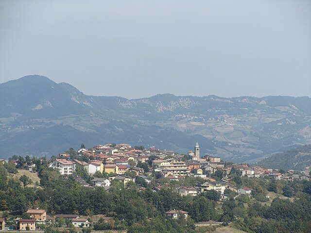
Villa Collemandina (Villa Collemandina)
.svg)
- Italian comune
 Hiking in Villa Collemandina
Villa Collemandina is a picturesque village located in the province of Lucca in Tuscany, Italy. Nestled in the Apennine Mountains, it offers stunning views and a variety of hiking opportunities that cater to different skill levels. Here are some key aspects of hiking in this area:
Scenic Trails
-
Diverse Terrain: The trails around Villa Collemandina vary from gentle walks along streams and through forests to more strenuous hikes that lead to panoramic viewpoints in the mountains.
-
Nature Reserves: The nearby Garfagnana region includes several protected areas and national parks, such as the Apuan Alps Natural Park. Hiking in this area gives you the chance to experience rich biodiversity and unique geological formations.
-
Historical Routes: Some hiking paths follow ancient trade routes that were used for centuries, allowing you to combine outdoor activity with a bit of history.
Trail Highlights
- Monte Prado: The highest peak in the Tuscan Apennines, offering breathtaking views and challenging trails.
- Passo del Cerreto: A scenic area with several trails that can lead to various summits and beautiful natural settings.
- Lago di Gramolazzo: A nice spot for hiking, which features a lake and surrounding trails that are great for walking and enjoying the scenery.
Preparation and Safety
- Seasonal Considerations: Spring and autumn are ideal for hiking in this region, as the temperatures are mild, and the landscapes are especially beautiful with blooming flowers or autumn colors.
- Trail Conditions: Always check the condition of the trails before heading out, as weather can change rapidly in mountainous regions.
- Equipment: Wear sturdy hiking boots and bring appropriate gear such as water, snacks, a map or GPS device, and a first-aid kit.
Local Tips
- Guided Tours: If you are new to the area or prefer to hike with a group, consider joining a guided hike to learn more about the local flora, fauna, and history.
- Culinary Delights: After a day of hiking, don't miss the chance to try local dishes at nearby restaurants, which may feature ingredients sourced from the surrounding countryside.
Overall, hiking in Villa Collemandina provides a fantastic opportunity to explore the natural beauty and cultural heritage of Tuscany. Whether you're a seasoned hiker or a beginner, you'll find paths that inspire adventure and tranquility alike.
- Country:

- Postal Code: 55030
- Local Dialing Code: 0583
- Licence Plate Code: LU
- Coordinates: 44° 10' 0" N, 10° 24' 0" E


- GPS tracks (wikiloc): [Link]
- AboveSeaLevel: 549 м m
- Area: 34.79 sq km
- Population: 1309
- Web site: http://www.comune.villacollemandina.lu.it
- Wikipedia en: wiki(en)
- Wikipedia: wiki(it)
- Wikidata storage: Wikidata: Q221592
- Wikipedia Commons Category: [Link]
- Freebase ID: [/m/0glbl1]
- GeoNames ID: Alt: [6543597]
- OSM relation ID: [42906]
- ISTAT ID: 046035
- Italian cadastre code: L926
Shares border with regions:

Villa Minozzo
- Italian comune
Hiking in Villa Minozzo
Villa Minozzo is a picturesque municipality located in the Emilia-Romagna region of Italy, nestled in the Apennine Mountains. This area is known for its stunning natural landscapes, historical sites, and a variety of outdoor activities, including hiking....
- Country:
- Postal Code: 42030
- Local Dialing Code: 0522
- Licence Plate Code: RE
- Coordinates: 44° 22' 0" N, 10° 27' 0" E
- GPS tracks (wikiloc): [Link]
- AboveSeaLevel: 684 м m
- Area: 168.08 sq km
- Population: 3658
- Web site: [Link]
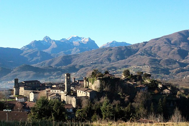

Castiglione di Garfagnana
- Italian comune
Hiking in Castiglione di Garfagnana
Castiglione di Garfagnana, located in the province of Lucca in Tuscany, Italy, is a beautiful area for hiking enthusiasts. Surrounded by the Apuan Alps and the Apennines, the region offers a variety of trails that cater to different skill levels, from leisure walks to more challenging hikes....
- Country:
- Postal Code: 55033
- Local Dialing Code: 0583
- Licence Plate Code: LU
- Coordinates: 44° 9' 3" N, 10° 24' 42" E
- GPS tracks (wikiloc): [Link]
- AboveSeaLevel: 545 м m
- Area: 48.53 sq km
- Population: 1783
- Web site: [Link]

Pieve Fosciana
- Italian comune
Hiking in Pieve Fosciana
Pieve Fosciana is a charming village located in the Garfagnana region of Tuscany, Italy, surrounded by beautiful landscapes, making it an excellent destination for hiking enthusiasts. Here are some highlights and tips for hiking in and around Pieve Fosciana:...
- Country:
- Postal Code: 55036
- Local Dialing Code: 0583
- Licence Plate Code: LU
- Coordinates: 44° 7' 58" N, 10° 24' 43" E
- GPS tracks (wikiloc): [Link]
- AboveSeaLevel: 369 м m
- Area: 28.76 sq km
- Population: 2484
- Web site: [Link]


San Romano in Garfagnana
- Italian comune
Hiking in San Romano in Garfagnana
San Romano in Garfagnana is a picturesque village located in the Garfagnana region of Tuscany, Italy. This area is known for its stunning natural beauty, rugged landscapes, and rich cultural heritage, making it a fantastic destination for hiking enthusiasts....
- Country:
- Postal Code: 55038
- Local Dialing Code: 0583
- Licence Plate Code: LU
- Coordinates: 44° 10' 0" N, 10° 21' 0" E
- GPS tracks (wikiloc): [Link]
- AboveSeaLevel: 555 м m
- Area: 26.16 sq km
- Population: 1408
- Web site: [Link]