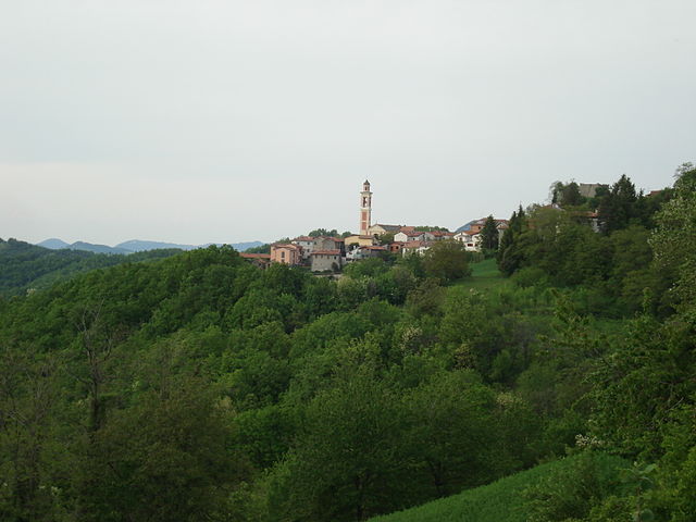
San Sebastiano Curone (San Sebastiano Curone)
- municipality in Italy
 Hiking in San Sebastiano Curone
San Sebastiano Curone is a charming village in the province of Alessandria, nestled in the picturesque hills of the Piedmont region of Italy. The surrounding area offers a fantastic landscape for hiking enthusiasts, combining lush vegetation, rolling hills, and scenic views.
Hiking Trails
-
Sentiero dei Laghi del Curone: This trail is suitable for all levels and takes you around the beautiful Curone lakes. The hike provides a mix of flat and slightly challenging terrains, perfect for family outings.
-
Monte Giarolo: For those seeking a more strenuous hike, the trail to Monte Giarolo offers stunning panoramic views of the Apennines and the Po Valley. The ascent can be challenging but is rewarding, especially at the summit.
-
Natural Park of Capanne di Marcarolo: Just a short drive from San Sebastiano Curone, this park features a network of trails. You can hike through varied landscapes including forests, meadows, and rivers, and spot local wildlife.
Tips for Hiking in San Sebastiano Curone
- Safety First: Always carry a map or GPS, as some trails may not be well-marked.
- Check Weather Conditions: The weather can change suddenly in the hills, so it's wise to check forecasts before you head out.
- Dress Appropriately: Wear comfortable, weather-appropriate clothing and sturdy footwear, as trails can be uneven and muddy.
- Stay Hydrated: Bring plenty of water and snacks to keep your energy up during your hikes.
- Respect Nature: Follow the Leave No Trace principles to help preserve the natural beauty of the area.
Best Time to Hike
Spring and early autumn are ideal for hiking in this region, as temperatures are mild and the landscapes are especially beautiful with blooming flowers or colorful fall foliage. Summer can be warm, while winter hikes might lead to snow-covered trails, which can require additional gear.
Whether you’re a seasoned hiker or just looking for a leisurely stroll in nature, San Sebastiano Curone and its surroundings offer a variety of opportunities to connect with the outdoors. Enjoy your hike!
- Country:

- Postal Code: 15056
- Local Dialing Code: 0131
- Licence Plate Code: AL
- Coordinates: 44° 47' 15" N, 9° 3' 57" E


- GPS tracks (wikiloc): [Link]
- AboveSeaLevel: 342 м m
- Area: 3.89 sq km
- Population: 576
- Web site: http://www.comunesansebastiano.it
- Wikipedia en: wiki(en)
- Wikipedia: wiki(it)
- Wikidata storage: Wikidata: Q17664
- Wikipedia Commons Category: [Link]
- Freebase ID: [/m/0gbnwk]
- GeoNames ID: Alt: [6536445]
- OSM relation ID: [43619]
- ISTAT ID: 006155
- Italian cadastre code: I150
Shares border with regions:
Brignano-Frascata
- municipality in Italy
Brignano-Frascata is a charming municipality located in the province of Alessandria in the Piedmont region of Italy. Nestled in the Apennines, this area offers beautiful landscapes, dense forests, and various hiking trails that cater to different skill levels....
- Country:

- Postal Code: 15050
- Local Dialing Code: 0131
- Licence Plate Code: AL
- Coordinates: 44° 48' 50" N, 9° 2' 29" E


- GPS tracks (wikiloc): [Link]
- AboveSeaLevel: 288 м m
- Area: 17.53 sq km
- Population: 433
- Web site: [Link]

Dernice
- municipality in Italy
Dernice is a charming village in the Piedmont region of Italy, known for its beautiful landscapes and outdoor opportunities. While it may not be as widely recognized as some other hiking destinations, it offers interesting trails and scenic views, making it a lovely spot for hikers....
- Country:

- Postal Code: 15056
- Local Dialing Code: 0131
- Licence Plate Code: AL
- Coordinates: 44° 46' 3" N, 9° 3' 5" E


- GPS tracks (wikiloc): [Link]
- AboveSeaLevel: 600 м m
- Area: 18.28 sq km
- Population: 180
- Web site: [Link]

Gremiasco
- municipality in Italy
Gremiasco is a charming village located in the Piedmont region of Italy, surrounded by the beautiful scenery of the Italian Alps. While it may not be one of the most recognized hiking destinations, it offers opportunities for nature enthusiasts and hikers looking for a less crowded experience....
- Country:

- Postal Code: 15050
- Local Dialing Code: 0131
- Licence Plate Code: AL
- Coordinates: 44° 47' 50" N, 9° 6' 28" E


- GPS tracks (wikiloc): [Link]
- AboveSeaLevel: 395 м m
- Area: 17.38 sq km
- Population: 318
- Web site: [Link]
Montacuto
- municipality in Italy
Montacuto is a beautiful area for hiking, known for its stunning landscapes, diverse flora and fauna, and panoramic views. While it may not be as widely recognized as some major hiking destinations, it offers plenty of opportunities for outdoor enthusiasts. Here are some key points to consider:...
- Country:

- Postal Code: 15050
- Local Dialing Code: 0131
- Licence Plate Code: AL
- Coordinates: 44° 45' 59" N, 9° 6' 18" E


- GPS tracks (wikiloc): [Link]
- AboveSeaLevel: 525 м m
- Area: 23.75 sq km
- Population: 263
- Web site: [Link]