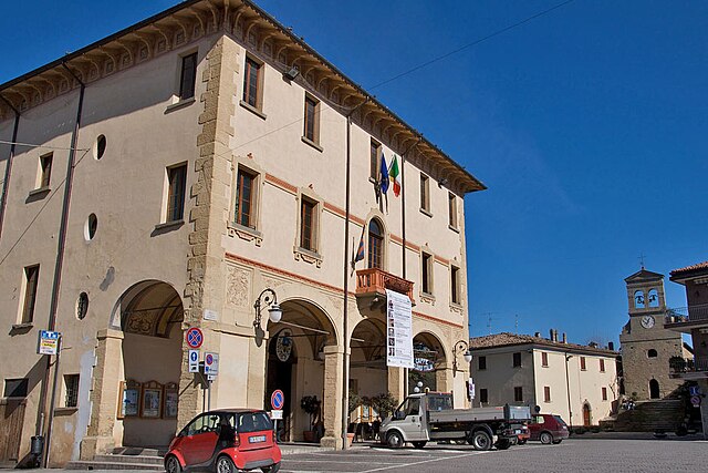
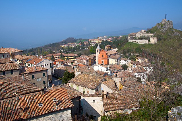
Sant'Agata Feltria (Sant'Agata Feltria)
.svg)
- Italian comune
 Hiking in Sant'Agata Feltria
Sant'Agata Feltria is a charming town located in the Emilia-Romagna region of Italy, surrounded by beautiful natural landscapes, making it an excellent destination for hiking enthusiasts. Here’s what you should know about hiking in this area:
Scenic Trails
-
Nature Trails: The surrounding hills and valleys offer a network of well-marked trails that cater to different skill levels. Many of these trails provide stunning views of the Apennine mountains and the picturesque countryside.
-
Monte Carpegna: One of the most popular hiking destinations near Sant'Agata Feltria, Monte Carpegna offers several trails that lead to its summit, which provides panoramic views. The area is rich in biodiversity, so you'll likely encounter various flora and fauna along the way.
-
Forests and Rivers: Many trails meander through dense forests and alongside rivers, providing opportunities to enjoy the tranquility of nature. The Sasso di Simone and Simoncello Natural Park nearby is also worth exploring, as it features rugged terrain and unique geological formations.
Recommended Hikes
-
Sentiero Naturalistico: A well-marked trail that provides insights into the local ecosystem and is suitable for families. It typically features gentle slopes and beautiful scenery.
-
The Path of San Francesco: This historic trail connects various hermitages and churches, allowing hikers to appreciate the spiritual aspect of the landscape while enjoying the beautiful frescoes and architecture.
Best Time to Hike
Spring (April to June) and fall (September to October) are ideal for hiking in Sant'Agata Feltria, as the weather is generally mild and the landscapes are particularly beautiful during these seasons. Summer can be hot, while winter hiking is possible but may require additional gear due to snow.
Practical Tips
- Maps and Guides: Before heading out, obtain a detailed map of the trails or consider hiring a local guide familiar with the area.
- Gear: Wear appropriate hiking shoes and layered clothing, as weather conditions can change rapidly in the mountains.
- Stay Hydrated and Fueled: Bring plenty of water and snacks, especially for longer hikes.
Local Culture
Don't forget to take some time to explore the town itself, which is known for its local cuisine and historical architecture. Sampling local dishes can be a great way to reward yourself after a day's hike!
Overall, Sant'Agata Feltria offers a unique combination of natural beauty and cultural richness, making it a fantastic destination for outdoor activities and exploration. Happy hiking!
- Country:

- Postal Code: 47866
- Local Dialing Code: 0547
- Licence Plate Code: RN
- Coordinates: 43° 51' 50" N, 12° 12' 31" E


- GPS tracks (wikiloc): [Link]
- AboveSeaLevel: 606 м m
- Area: 79.74 sq km
- Population: 2121
- Web site: http://www.comune.santagatafeltria.ps.it/
- Wikipedia en: wiki(en)
- Wikipedia: wiki(it)
- Wikidata storage: Wikidata: Q111949
- Wikipedia Commons Category: [Link]
- Freebase ID: [/m/0gl53v]
- GeoNames ID: Alt: [6538503]
- VIAF ID: Alt: [236587463]
- OSM relation ID: [42647]
- GND ID: Alt: [4829842-6]
- UN/LOCODE: [ITSEF]
- ISTAT ID: 099026
- Italian cadastre code: I201
Shares border with regions:


Casteldelci
- Italian comune
Hiking in Casteldelci
Casteldelci is a charming village located in the Emilia-Romagna region of Italy, nestled in the beautiful hills of the Appennine Mountains. Known for its stunning landscapes and rich natural diversity, the area offers a variety of hiking opportunities for all levels of experience. Here are some key aspects to consider when hiking in Casteldelci:...
- Country:
- Postal Code: 47861
- Local Dialing Code: 0541
- Licence Plate Code: RN
- Coordinates: 43° 47' 29" N, 12° 9' 19" E
- GPS tracks (wikiloc): [Link]
- AboveSeaLevel: 632 м m
- Area: 49.68 sq km
- Population: 389
- Web site: [Link]

Novafeltria
- Italian comune
Hiking in Novafeltria
Novafeltria, located in the Emilia-Romagna region of Italy, is surrounded by the stunning landscapes of the Apennine Mountains. This area offers a variety of hiking opportunities for different skill levels. Here’s what you can expect when hiking in Novafeltria:...
- Country:
- Postal Code: 47863
- Local Dialing Code: 0541
- Licence Plate Code: RN
- Coordinates: 43° 53' 43" N, 12° 17' 26" E
- GPS tracks (wikiloc): [Link]
- AboveSeaLevel: 275 м m
- Area: 41.84 sq km
- Population: 7119
- Web site: [Link]

Pennabilli
- Italian comune
Hiking in Pennabilli
Pennabilli is a picturesque town located in the Emilia-Romagna region of Italy, known for its stunning landscapes, historical significance, and rich natural beauty. It’s an excellent destination for hiking enthusiasts who seek to explore the outdoors while enjoying cultural heritage....
- Country:
- Postal Code: 47864
- Local Dialing Code: 0541
- Licence Plate Code: RN
- Coordinates: 43° 49' 8" N, 12° 16' 0" E
- GPS tracks (wikiloc): [Link]
- AboveSeaLevel: 629 м m
- Area: 69.66 sq km
- Population: 2772
- Web site: [Link]


Badia Tedalda
- Italian comune
Hiking in Badia Tedalda
Badia Tedalda is a beautiful destination located in the province of Arezzo in Tuscany, Italy. Nestled in the Valtiberina valley, this area is known for its stunning landscapes, rich history, and natural beauty, making it an excellent spot for hiking enthusiasts....
- Country:
- Postal Code: 53032
- Local Dialing Code: 0575
- Licence Plate Code: AR
- Coordinates: 43° 42' 29" N, 12° 11' 14" E
- GPS tracks (wikiloc): [Link]
- AboveSeaLevel: 700 м m
- Area: 119.03 sq km
- Population: 1075
- Web site: [Link]


Sarsina
- Italian comune
Hiking in Sarsina
Sarsina, located in the Emilia-Romagna region of Italy, is a charming town that offers various hiking opportunities amidst beautiful landscapes and rich historical and cultural heritage. The surrounding area includes the Appenine Mountains, which provide a variety of trails suitable for different skill levels....
- Country:
- Postal Code: 47027
- Local Dialing Code: 0547
- Licence Plate Code: FC
- Coordinates: 43° 55' 0" N, 12° 9' 0" E
- GPS tracks (wikiloc): [Link]
- AboveSeaLevel: 243 м m
- Area: 100 sq km
- Population: 3662
- Web site: [Link]
Sogliano al Rubicone
- Italian comune
Hiking in Sogliano al Rubicone
Sogliano al Rubicone is a charming town located in the Emilia-Romagna region of Italy, known for its beautiful landscapes, rich history, and delicious cuisine. Hiking in this area offers a unique experience, combining natural beauty with cultural heritage....
- Country:
- Postal Code: 47030
- Local Dialing Code: 0541; 0541 - 0547
- Licence Plate Code: FC
- Coordinates: 44° 0' 0" N, 12° 18' 0" E
- GPS tracks (wikiloc): [Link]
- AboveSeaLevel: 362 м m
- Area: 93.43 sq km
- Population: 3230
- Web site: [Link]
Verghereto
- Italian comune
Hiking in Verghereto
Verghereto, located in the province of Forlì-Cesena in Emilia-Romagna, Italy, is an excellent destination for hiking enthusiasts. Nestled in the Apennine Mountains, the region is characterized by its stunning landscapes, lush forests, and a variety of trails suitable for different skill levels....
- Country:
- Postal Code: 47028
- Local Dialing Code: 0543
- Licence Plate Code: FC
- Coordinates: 43° 48' 0" N, 11° 58' 0" E
- GPS tracks (wikiloc): [Link]
- AboveSeaLevel: 812 м m
- Area: 117.9 sq km
- Population: 1860
- Web site: [Link]