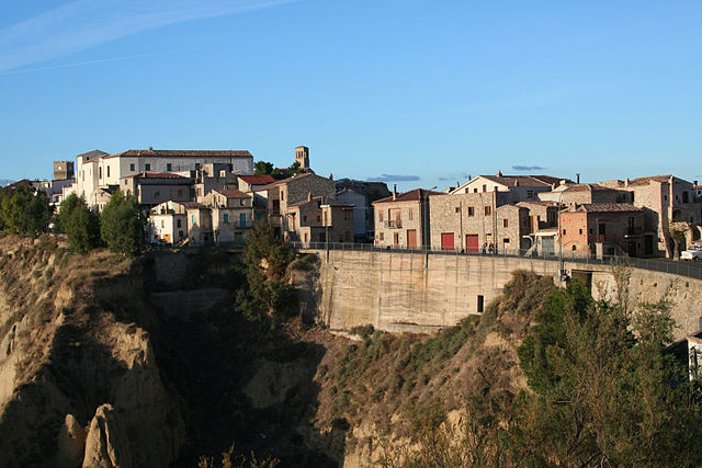
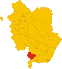
Sant'Arcangelo (Sant'Arcangelo)
.svg)
- Italian comune
 Hiking in Sant'Arcangelo
Sant'Arcangelo, located in the Basilicata region of Italy, is known for its beautiful landscapes, rich history, and charming architecture. Hiking in this area can be a rewarding experience, offering stunning views and opportunities to explore the natural and cultural heritage of the region.
Hiking Highlights in Sant'Arcangelo:
-
Cultural and Historical Significance:
- Sant'Arcangelo is characterized by its ancient buildings and panoramic views of the surrounding landscape. You can combine hiking with a bit of cultural exploration, visiting historical sites or quaint villages along the way.
-
Scenic Trails:
- There are various trails around Sant'Arcangelo that cater to different skill levels. The routes typically pass through rolling hills, forests, and areas with stunning rock formations. The surrounding landscape is part of the Pollino National Park, which offers diverse ecosystems and natural beauty.
-
Pollino National Park:
- This park is the largest in Italy and offers abundant opportunities for hiking. It features a variety of trails ranging from easy walks to challenging hikes with significant elevation changes. The park is also home to unique flora and fauna, making it a great spot for nature enthusiasts.
-
Local Flora and Fauna:
- As you hike, you'll likely encounter diverse plant species and possibly spot wildlife such as deer, various bird species, and other local animals. The region's ecological diversity makes it a great place for both casual hikers and biology enthusiasts.
-
Best Times to Hike:
- The ideal seasons for hiking in Sant'Arcangelo are spring (April to June) and fall (September to October), when the weather is mild and the scenery is particularly beautiful with blooming flowers or autumn foliage. Summer can be quite hot, and winter may bring snow in higher elevations.
Tips for Hiking in Sant'Arcangelo:
- Preparation: Ensure you have a good map or GPS device, as trails can vary in signage. Familiarize yourself with trail conditions and difficulty levels.
- Safety Equipment: Carry enough water, snacks, and a first-aid kit. Depending on the trail, trekking poles can also be beneficial.
- Footwear: Wear sturdy hiking boots or shoes with good grip, as the terrain can be rocky and uneven.
- Weather Awareness: Check the weather forecast before heading out and be prepared for sudden changes, especially in mountainous areas.
- Respect Nature: Follow Leave No Trace principles to preserve the natural beauty of the area.
Hiking in Sant'Arcangelo provides a unique blend of nature and culture, making it an enriching experience for all adventurers. Enjoy your trekking in this beautiful part of Italy!
- Country:

- Postal Code: 85037
- Local Dialing Code: 0973
- Licence Plate Code: PZ
- Coordinates: 40° 14' 55" N, 16° 16' 14" E


- GPS tracks (wikiloc): [Link]
- AboveSeaLevel: 388 м m
- Area: 89.1 sq km
- Population: 6448
- Web site: http://www.comunesmcoghinas.it
- Wikipedia en: wiki(en)
- Wikipedia: wiki(it)
- Wikidata storage: Wikidata: Q52669
- Wikipedia Commons Category: [Link]
- Freebase ID: [/m/0fh3w1]
- GeoNames ID: Alt: [6540032]
- VIAF ID: Alt: [127581748]
- OSM relation ID: [40353]
- Library of Congress authority ID: Alt: [n2002025389]
- UN/LOCODE: [ITSQR]
- Digital Atlas of the Roman Empire ID: [30391]
- ISTAT ID: 076080
- Italian cadastre code: I305
Shares border with regions:

Aliano
- Italian comune
Hiking in Aliano
Aliano is a small village located in the Basilicata region of southern Italy. It is known for its stunning landscapes, rugged terrain, and rich cultural heritage. While primarily recognized for its historical significance and as a filming location for the Italian movie "Christ Stopped at Eboli," Aliano and its surrounding areas offer beautiful hiking opportunities for outdoor enthusiasts....
- Country:
- Postal Code: 75010
- Local Dialing Code: 0835
- Licence Plate Code: MT
- Coordinates: 40° 19' 0" N, 16° 14' 0" E
- GPS tracks (wikiloc): [Link]
- AboveSeaLevel: 498 м m
- Area: 98.41 sq km
- Population: 967
- Web site: [Link]

Colobraro
- Italian comune
Hiking in Colobraro
Colobraro is a small hilltop village located in the Basilicata region of southern Italy, known for its stunning landscapes, historical charm, and various hiking opportunities. While it may not be as widely recognized as some other hiking destinations in Italy, it offers a unique experience for those looking to explore serene trails and enjoy nature....
- Country:
- Postal Code: 75021
- Local Dialing Code: 0835
- Licence Plate Code: MT
- Coordinates: 40° 11' 0" N, 16° 26' 0" E
- GPS tracks (wikiloc): [Link]
- AboveSeaLevel: 630 м m
- Area: 66.61 sq km
- Population: 1203
- Web site: [Link]


Stigliano
- Italian comune
Hiking in Stigliano
Stigliano is a charming town located in the Basilicata region of southern Italy, known for its beautiful landscapes and opportunities for outdoor activities, including hiking. While the town might not be as famous as some other Italian hiking destinations, it offers a unique experience for outdoor enthusiasts who are looking to explore scenic trails and enjoy nature....
- Country:
- Postal Code: 75018
- Local Dialing Code: 0835
- Licence Plate Code: MT
- Coordinates: 40° 24' 9" N, 16° 13' 47" E
- GPS tracks (wikiloc): [Link]
- AboveSeaLevel: 909 м m
- Area: 211.15 sq km
- Population: 4112
- Web site: [Link]


Tursi
- Italian comune
Hiking in Tursi
Tursi is a charming town located in the Basilicata region of Southern Italy, known for its rich history and beautiful landscapes. While it may not be as well-known as some other hiking destinations in Italy, Tursi and its surrounding areas offer some lovely opportunities for outdoor enthusiasts....
- Country:
- Postal Code: 75028
- Local Dialing Code: 0835
- Licence Plate Code: MT
- Coordinates: 40° 15' 0" N, 16° 28' 0" E
- GPS tracks (wikiloc): [Link]
- AboveSeaLevel: 243 м m
- Area: 159.93 sq km
- Population: 4981
- Web site: [Link]
Roccanova
- Italian comune
Hiking in Roccanova
Roccanova is a charming destination located in the Basilicata region of southern Italy. Nestled in the Apennine Mountains, it offers a range of hiking opportunities for outdoor enthusiasts. Here’s a guide to help you explore the hiking options in and around Roccanova:...
- Country:
- Postal Code: 85036
- Local Dialing Code: 0973
- Licence Plate Code: PZ
- Coordinates: 40° 13' 0" N, 16° 12' 0" E
- GPS tracks (wikiloc): [Link]
- AboveSeaLevel: 648 м m
- Area: 61.74 sq km
- Population: 1477
- Web site: [Link]
Senise
- Italian comune
Hiking in Senise
Senise, a charming town located in the Basilicata region of Italy, offers an array of hiking opportunities in a stunning natural environment. The surrounding area is characterized by rolling hills, lush forests, and breathtaking views. Here are some highlights and suggestions for hiking in Senise:...
- Country:
- Postal Code: 85038
- Local Dialing Code: 0973
- Licence Plate Code: PZ
- Coordinates: 40° 8' 0" N, 16° 17' 0" E
- GPS tracks (wikiloc): [Link]
- AboveSeaLevel: 335 м m
- Area: 97.31 sq km
- Population: 6995
- Web site: [Link]