Sant'Arsenio (Sant'Arsenio)

- Italian comune
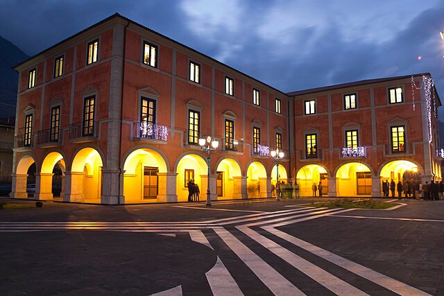
 Hiking in Sant'Arsenio
Sant'Arsenio, located in the Campania region of Italy, is surrounded by stunning natural landscapes, making it an excellent destination for hiking enthusiasts. The area features the scenic backdrop of the Appennine Mountains, offering varied terrain and a range of trails for hikers of all levels.
Hiking Opportunities
-
Local Trails: Sant’Arsenio has several marked trails that wind through woodlands, hillsides, and valleys. These paths often provide beautiful views, opportunities to see local flora and fauna, and the chance to explore charming rural landscapes.
-
Monte Cervati: A short distance away lies Monte Cervati, the highest peak in the Campania region. Reaching the summit offers a rewarding challenge with panoramic views of the surrounding mountains and valleys. The trails here are more demanding, making them suitable for experienced hikers.
-
Parco Nazionale del Cilento: If you venture a little farther, you can explore the Cilento and Vallo di Diano National Park, which is recognized for its biodiversity and stunning natural scenery. The park features extensive network of well-marked paths, from easy walks to more strenuous routes.
Tips for Hiking in Sant'Arsenio
-
Best Time to Hike: The ideal times for hiking are spring and early autumn when temperatures are more pleasant. Summer can be hot, and winter may bring snow to higher elevations.
-
Gear: Ensure you wear sturdy hiking shoes and carry sufficient water, snacks, a map, and a first-aid kit. Depending on the season, pack layers to accommodate changing temperatures.
-
Guided Tours: If you’re unfamiliar with the area, consider joining a guided hike. Local guides can provide insights into the region's history, culture, and ecology.
-
Respect Nature: Stay on designated trails, follow Leave No Trace principles, and be cautious of wildlife.
Cultural Aspects
Hiking in Sant'Arsenio also offers opportunities to experience local culture. You can explore nearby villages, enjoy regional cuisine, and discover historical sites along the way.
Whether you're after challenging mountain trails or leisurely walks through picturesque scenery, Sant'Arsenio provides a beautiful setting for all those who appreciate the outdoors. Happy hiking!
- Country:

- Postal Code: 84037
- Local Dialing Code: 0975
- Licence Plate Code: SA
- Coordinates: 40° 28' 0" N, 15° 29' 0" E


- GPS tracks (wikiloc): [Link]
- AboveSeaLevel: 448 м m
- Area: 20.14 sq km
- Population: 2815
- Web site: http://santarsenio.asmenet.it
- Wikipedia en: wiki(en)
- Wikipedia: wiki(it)
- Wikidata storage: Wikidata: Q81608
- Wikipedia Commons Category: [Link]
- Freebase ID: [/m/0frgy3]
- GeoNames ID: Alt: [6537415]
- VIAF ID: Alt: [304910725]
- OSM relation ID: [40504]
- ISTAT ID: 065129
- Italian cadastre code: I307
Shares border with regions:


Atena Lucana
- Italian comune
Hiking in Atena Lucana
Atena Lucana is a charming town located in the province of Salerno, in the Campania region of southern Italy. It is surrounded by the beautiful natural landscape of the Lucanian Apennines and is near the breathtaking Cilento and Vallo di Diano National Park, making it an excellent destination for hiking enthusiasts....
- Country:
- Postal Code: 84030
- Local Dialing Code: 0975
- Licence Plate Code: SA
- Coordinates: 40° 27' 0" N, 15° 33' 0" E
- GPS tracks (wikiloc): [Link]
- AboveSeaLevel: 642 м m
- Area: 26.01 sq km
- Population: 2402
- Web site: [Link]


Corleto Monforte
- Italian comune
Hiking in Corleto Monforte
Corleto Monforte is a charming small town located in the region of Basilicata in southern Italy. This area is characterized by its stunning natural beauty, with a mix of rolling hills, rugged mountains, and beautiful landscapes, making it an excellent destination for hiking enthusiasts....
- Country:
- Postal Code: 84020
- Local Dialing Code: 0828
- Licence Plate Code: SA
- Coordinates: 40° 26' 0" N, 15° 23' 0" E
- GPS tracks (wikiloc): [Link]
- AboveSeaLevel: 683 м m
- Area: 58.97 sq km
- Population: 567
- Web site: [Link]


Polla
- Italian comune
Hiking in Polla
Polla, a charming town located in the Campania region of Italy, is often overlooked by tourists but offers a wealth of natural beauty and hiking opportunities. Nestled in the heart of the Alburni Mountains, it serves as an ideal base for those looking to explore scenic trails, lush landscapes, and authentic Italian culture....
- Country:
- Postal Code: 84035
- Local Dialing Code: 0975
- Licence Plate Code: SA
- Coordinates: 40° 31' 0" N, 15° 30' 0" E
- GPS tracks (wikiloc): [Link]
- AboveSeaLevel: 468 м m
- Area: 48.08 sq km
- Population: 5273
- Web site: [Link]

San Pietro al Tanagro
- Italian comune
Hiking in San Pietro al Tanagro
San Pietro al Tanagro is a charming village located in the Campania region of southern Italy, nestled within the natural beauty of the Cilento and Vallo di Diano National Park. This area is known for its stunning landscapes, rich biodiversity, and numerous hiking trails suited for various skill levels....
- Country:
- Postal Code: 84030
- Local Dialing Code: 0975
- Licence Plate Code: SA
- Coordinates: 40° 27' 23" N, 15° 28' 59" E
- GPS tracks (wikiloc): [Link]
- AboveSeaLevel: 465 м m
- Area: 15.51 sq km
- Population: 1707
- Web site: [Link]


San Rufo
- Italian comune
Hiking in San Rufo
San Rufo is a charming village located in the Campania region of Italy, known for its beautiful landscapes and rich cultural history. While it may not be as widely recognized as some other hiking destinations in Italy, it offers some lovely trails and opportunities for outdoor activities....
- Country:
- Postal Code: 84030
- Local Dialing Code: 0975
- Licence Plate Code: SA
- Coordinates: 40° 26' 0" N, 15° 28' 0" E
- GPS tracks (wikiloc): [Link]
- AboveSeaLevel: 640 м m
- Area: 31.96 sq km
- Population: 1702
- Web site: [Link]


Teggiano
- Italian comune
Hiking in Teggiano
Teggiano, located in the province of Salerno in the Campania region of Italy, is a charming medieval town that offers stunning landscapes and various hiking opportunities. Here are some highlights for hiking in the Teggiano area:...
- Country:
- Postal Code: 84039
- Local Dialing Code: 0975
- Licence Plate Code: SA
- Coordinates: 40° 23' 0" N, 15° 32' 0" E
- GPS tracks (wikiloc): [Link]
- AboveSeaLevel: 637 м m
- Area: 61.87 sq km
- Population: 7794
- Web site: [Link]