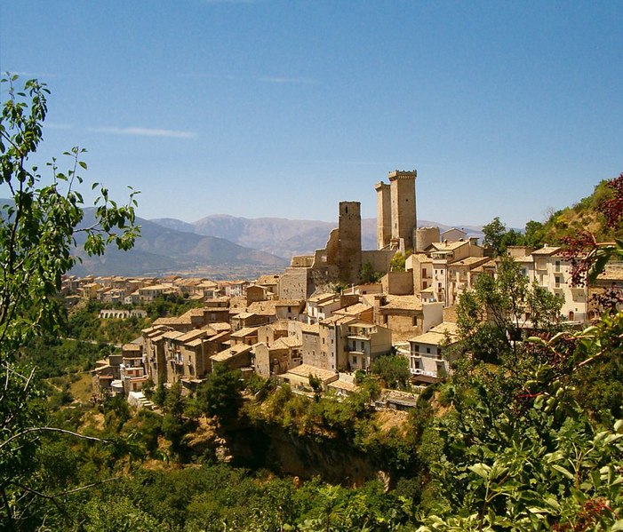
Sant'Eufemia a Maiella (Sant'Eufemia a Maiella)
- Italian comune
 Hiking in Sant'Eufemia a Maiella
Sant'Eufemia a Maiella is a beautiful village located in the Abruzzo region of Italy, surrounded by the stunning landscapes of the Maiella National Park. It's an excellent destination for hiking enthusiasts, offering a variety of trails that cater to different skill levels. Here are some key points to consider when hiking in this area:
Hiking Trails
-
Sentiero della Libertà: This is a well-known trail that commemorates the historical routes taken during World War II. It provides beautiful views and a chance to learn about the region's history.
-
Cima della Majella: For those seeking a challenge, the hike to the summit of Cima della Majella offers breathtaking panoramic views and a rewarding experience.
-
Valle dell'Orfento: This trail takes you through a picturesque valley characterized by rocky cliffs, lush forests, and clear streams. It's perfect for those looking to enjoy a mix of nature and tranquility.
-
Gole di Fara San Martino: This trail offers dramatic scenery with eroded cliffs and deep gorges. It's a bit more demanding but rewards hikers with stunning landscape views.
Best Time to Hike
The best time to hike in Sant'Eufemia a Maiella is typically from late spring (May) to early autumn (October) when the weather is milder and the trails are accessible. Summer can be warm, so early morning hikes are advisable to avoid the heat.
Preparation
- Gear: Ensure you are equipped with proper hiking boots, weather-appropriate clothing, and plenty of water and snacks.
- Map and Compass: While many trails are well-marked, it's always beneficial to carry a map and compass or a GPS device.
- Local Regulations: Respect local wildlife and flora. Stay on marked trails, and be aware of any specific regulations within the national park.
Safety Tips
- Check Weather Conditions: Mountain weather can be unpredictable. Always check the forecast before heading out.
- Hiking Companions: If possible, hike with a companion and inform someone about your plans, especially if you're heading to remote areas.
- Emergency Plan: Have a plan in case of emergencies, including knowing the nearest ranger station or emergency services.
Exploring the hiking trails around Sant'Eufemia a Maiella offers not only physical challenges but also opportunities to bask in the natural beauty and rich culture of the Abruzzo region. Enjoy your hike!
- Country:

- Postal Code: 65020
- Local Dialing Code: 085
- Licence Plate Code: PE
- Coordinates: 42° 7' 0" N, 14° 1' 0" E


- GPS tracks (wikiloc): [Link]
- AboveSeaLevel: 878 м m
- Area: 40.42 sq km
- Population: 263
- Web site: http://www.santeufemia.gov.it/
- Wikipedia en: wiki(en)
- Wikipedia: wiki(it)
- Wikidata storage: Wikidata: Q51391
- Wikipedia Commons Gallery: [Link]
- Wikipedia Commons Category: [Link]
- Freebase ID: [/m/0fg8x4]
- GeoNames ID: Alt: [6541220]
- OSM relation ID: [41777]
- TGN ID: [1046689]
- ISTAT ID: 068037
- Italian cadastre code: I332
Shares border with regions:


Pacentro
- Italian comune
Pacentro, located in the Abruzzo region of Italy, is a charming hilltop village known for its stunning views, ancient architecture, and access to beautiful natural landscapes. Hiking in and around Pacentro offers a unique experience, blending culture, history, and nature....
- Country:

- Postal Code: 67030
- Local Dialing Code: 0864
- Licence Plate Code: AQ
- Coordinates: 42° 3' 2" N, 13° 59' 29" E


- GPS tracks (wikiloc): [Link]
- AboveSeaLevel: 653 м m
- Area: 72.59 sq km
- Population: 1140
- Web site: [Link]


Sulmona
- Italian comune
Sulmona, located in the Abruzzo region of Italy, is renowned for its stunning landscapes and rich cultural heritage, making it a fantastic destination for hiking enthusiasts. The surrounding area offers a diverse range of trails, from gentle walks to challenging hikes, many of which provide breathtaking views of the Apennine Mountains and the beautiful countryside....
- Country:

- Postal Code: 67039
- Local Dialing Code: 0864
- Licence Plate Code: AQ
- Coordinates: 42° 2' 53" N, 13° 55' 34" E


- GPS tracks (wikiloc): [Link]
- AboveSeaLevel: 405 м m
- Area: 58.33 sq km
- Population: 24173
- Web site: [Link]


Fara San Martino
- Italian comune
Fara San Martino, located in the Abruzzo region of Italy, is a beautiful destination for hiking enthusiasts. Nestled in the Majella National Park, this area is characterized by stunning natural landscapes, dramatic mountains, and a rich array of flora and fauna. Here are some key points about hiking in Fara San Martino:...
- Country:

- Postal Code: 66015
- Local Dialing Code: 0872
- Licence Plate Code: CH
- Coordinates: 42° 5' 28" N, 14° 12' 22" E


- GPS tracks (wikiloc): [Link]
- AboveSeaLevel: 440 м m
- Area: 44.69 sq km
- Population: 1379
- Web site: [Link]


Caramanico Terme
- Italian comune
Caramanico Terme is a charming village located in the Abruzzo region of Italy, renowned for its thermal springs and stunning natural beauty. It’s nestled in the Majella National Park, making it an excellent destination for hiking enthusiasts. Here are some key points about hiking in the area:...
- Country:

- Postal Code: 65023
- Local Dialing Code: 085
- Licence Plate Code: PE
- Coordinates: 42° 9' 0" N, 14° 1' 0" E


- GPS tracks (wikiloc): [Link]
- AboveSeaLevel: 650 м m
- Area: 84.99 sq km
- Population: 1872
- Web site: [Link]
