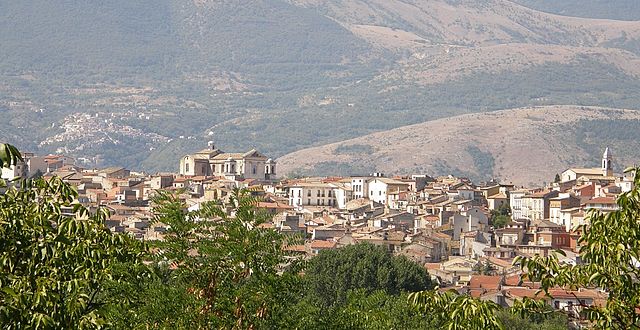
Caramanico Terme (Caramanico Terme)
.svg)
- Italian comune
 Hiking in Caramanico Terme
Caramanico Terme is a charming village located in the Abruzzo region of Italy, renowned for its thermal springs and stunning natural beauty. It’s nestled in the Majella National Park, making it an excellent destination for hiking enthusiasts. Here are some key points about hiking in the area:
Scenic Trails
- Maiella Massif: The trails around Caramanico Terme offer breathtaking views of the Maiella Massif, providing diverse landscapes, from rocky outcrops to forested paths.
- Nature Trails: There are numerous signposted trails of varying difficulty levels, suitable for both beginners and experienced hikers. Trails often weave through beautiful beech forests, past waterfalls, and along scenic ridges.
Popular Hiking Routes
- Valle dell'Orfento: This trail is known for its stunning scenery, including deep valleys and dramatic cliffs. The well-marked path takes you alongside the Orfento River, through lush vegetation.
- Pizzo di Focalone: A more challenging hike that rewards you with panoramic views from the summit. It’s a favorite for seasoned hikers looking for a rewarding climb.
- Sentiero del Parco: A moderate trail that introduces you to the local flora and fauna, offering interpretive signs along the way that educate hikers about the ecosystem.
Flora and Fauna
The region is rich in biodiversity, with numerous species of plants and animals. As you hike, you may encounter wild boars, deer, and a variety of bird species. Spring and early summer are particularly beautiful times to visit, as the wildflowers bloom vibrantly.
Thermal Springs
After a day of hiking, you may want to relax in the thermal baths that Caramanico Terme is famous for. This can be a wonderful way to unwind and soothe tired muscles from hiking.
Preparation and Safety
- Gear: It’s essential to wear appropriate hiking footwear and carry a good backpack with water, snacks, a first-aid kit, and a map or GPS device.
- Weather: Always check the weather conditions before setting out, as they can change rapidly in the mountains.
- Local Regulations: Respect local wildlife and follow Leave No Trace principles to preserve the natural beauty of the area.
Conclusion
Hiking in Caramanico Terme offers a unique combination of natural beauty, tranquility, and adventure. Whether you're looking for a leisurely stroll or a challenging hike, the region has something to offer for everyone. Always remember to plan ahead and enjoy the stunning landscapes and rich biodiversity that Abruzzo has to offer!
- Country:

- Postal Code: 65023
- Local Dialing Code: 085
- Licence Plate Code: PE
- Coordinates: 42° 9' 0" N, 14° 1' 0" E


- GPS tracks (wikiloc): [Link]
- AboveSeaLevel: 650 м m
- Area: 84.99 sq km
- Population: 1872
- Web site: http://www.comunecaramanicoterme.it/
- Wikipedia en: wiki(en)
- Wikipedia: wiki(it)
- Wikidata storage: Wikidata: Q51350
- Wikipedia Commons Gallery: [Link]
- Wikipedia Commons Category: [Link]
- Freebase ID: [/m/0fg8gg]
- GeoNames ID: Alt: [6541213]
- VIAF ID: Alt: [246997707]
- OSM relation ID: [41786]
- TGN ID: [7004174]
- ISTAT ID: 068007
- Italian cadastre code: B722
Shares border with regions:

Pratola Peligna
- Italian comune
Hiking in Pratola Peligna
Pratola Peligna, located in the province of L’Aquila in the Abruzzo region of Italy, is a beautiful area known for its stunning landscapes and rich natural heritage. Here are some aspects to consider for hiking in this region:...
- Country:
- Postal Code: 67035
- Local Dialing Code: 0864
- Licence Plate Code: AQ
- Coordinates: 42° 5' 57" N, 13° 52' 29" E
- GPS tracks (wikiloc): [Link]
- AboveSeaLevel: 342 м m
- Area: 28.67 sq km
- Population: 7528
- Web site: [Link]


Sulmona
- Italian comune
Hiking in Sulmona
Sulmona, located in the Abruzzo region of Italy, is renowned for its stunning landscapes and rich cultural heritage, making it a fantastic destination for hiking enthusiasts. The surrounding area offers a diverse range of trails, from gentle walks to challenging hikes, many of which provide breathtaking views of the Apennine Mountains and the beautiful countryside....
- Country:
- Postal Code: 67039
- Local Dialing Code: 0864
- Licence Plate Code: AQ
- Coordinates: 42° 2' 53" N, 13° 55' 34" E
- GPS tracks (wikiloc): [Link]
- AboveSeaLevel: 405 м m
- Area: 58.33 sq km
- Population: 24173
- Web site: [Link]

Bolognano
- Italian municipality
Hiking in Bolognano
Bolognano, a charming village in the Abruzzo region of Italy, is an excellent destination for hiking enthusiasts. Nestled in the foothills of the Apennines, it offers stunning landscapes, rich biodiversity, and a variety of trails suitable for different skill levels....
- Country:
- Postal Code: 65020
- Local Dialing Code: 085
- Licence Plate Code: PE
- Coordinates: 42° 13' 0" N, 13° 58' 0" E
- GPS tracks (wikiloc): [Link]
- AboveSeaLevel: 276 м m
- Area: 16.96 sq km
- Population: 1095
- Web site: [Link]


Fara San Martino
- Italian comune
Hiking in Fara San Martino
Fara San Martino, located in the Abruzzo region of Italy, is a beautiful destination for hiking enthusiasts. Nestled in the Majella National Park, this area is characterized by stunning natural landscapes, dramatic mountains, and a rich array of flora and fauna. Here are some key points about hiking in Fara San Martino:...
- Country:
- Postal Code: 66015
- Local Dialing Code: 0872
- Licence Plate Code: CH
- Coordinates: 42° 5' 28" N, 14° 12' 22" E
- GPS tracks (wikiloc): [Link]
- AboveSeaLevel: 440 м m
- Area: 44.69 sq km
- Population: 1379
- Web site: [Link]


Pennapiedimonte
- Italian comune
Hiking in Pennapiedimonte
Pennapiedimonte is a charming village located in the Abruzzo region of Italy, known for its stunning natural landscapes and rich biodiversity. The surrounding area offers various hiking opportunities that cater to different skill levels, making it a fantastic destination for both novice and experienced hikers....
- Country:
- Postal Code: 66010
- Local Dialing Code: 0871
- Licence Plate Code: CH
- Coordinates: 42° 9' 8" N, 14° 11' 41" E
- GPS tracks (wikiloc): [Link]
- AboveSeaLevel: 669 м m
- Area: 47.03 sq km
- Population: 445
- Web site: [Link]


Abbateggio
- Italian comune
Hiking in Abbateggio
Abbateggio, a picturesque village in the Abruzzo region of Italy, offers a fantastic setting for hiking enthusiasts. Nestled in the heart of the Majella National Park, it boasts stunning natural landscapes, rich flora and fauna, and breathtaking views of the surrounding mountains. Here are some key points to consider when hiking in Abbateggio:...
- Country:
- Postal Code: 65020
- Local Dialing Code: 085
- Licence Plate Code: PE
- Coordinates: 42° 14' 0" N, 14° 1' 0" E
- GPS tracks (wikiloc): [Link]
- AboveSeaLevel: 530 м m
- Area: 15.4 sq km
- Population: 371
- Web site: [Link]


Roccamorice
- Italian comune
Hiking in Roccamorice
Roccamorice is a charming village located in the Abruzzo region of Italy, known for its stunning natural landscapes and proximity to the Majella National Park. Here are some highlights for hiking in and around Roccamorice:...
- Country:
- Postal Code: 65020
- Local Dialing Code: 085
- Licence Plate Code: PE
- Coordinates: 42° 13' 0" N, 14° 2' 0" E
- GPS tracks (wikiloc): [Link]
- AboveSeaLevel: 520 м m
- Area: 25.06 sq km
- Population: 930
- Web site: [Link]


Salle, Abruzzo
- Italian comune
Hiking in Salle, Abruzzo
Salle, a charming village in the Abruzzo region of Italy, is surrounded by the stunning natural landscapes of the Majella National Park and the Gran Sasso and Monti della Laga National Park. This area offers a variety of hiking opportunities for all skill levels, featuring breathtaking views, rich biodiversity, and historical sites....
- Country:
- Postal Code: 65020
- Local Dialing Code: 085
- Licence Plate Code: PE
- Coordinates: 42° 10' 37" N, 13° 57' 35" E
- GPS tracks (wikiloc): [Link]
- AboveSeaLevel: 450 м m
- Area: 21.8 sq km
- Population: 291
- Web site: [Link]

Sant'Eufemia a Maiella
- Italian comune
Hiking in Sant'Eufemia a Maiella
Sant'Eufemia a Maiella is a beautiful village located in the Abruzzo region of Italy, surrounded by the stunning landscapes of the Maiella National Park. It's an excellent destination for hiking enthusiasts, offering a variety of trails that cater to different skill levels. Here are some key points to consider when hiking in this area:...
- Country:
- Postal Code: 65020
- Local Dialing Code: 085
- Licence Plate Code: PE
- Coordinates: 42° 7' 0" N, 14° 1' 0" E
- GPS tracks (wikiloc): [Link]
- AboveSeaLevel: 878 м m
- Area: 40.42 sq km
- Population: 263
- Web site: [Link]

San Valentino in Abruzzo Citeriore
- Italian comune
Hiking in San Valentino in Abruzzo Citeriore
San Valentino in Abruzzo Citeriore is a charming village located in the Abruzzo region of Italy, surrounded by picturesque landscapes and a variety of hiking opportunities. The area is known for its natural beauty, characterized by rolling hills, lush forests, and stunning views of the Gran Sasso and Majella mountains....
- Country:
- Postal Code: 65020
- Local Dialing Code: 085
- Licence Plate Code: PE
- Coordinates: 42° 14' 0" N, 13° 59' 0" E
- GPS tracks (wikiloc): [Link]
- AboveSeaLevel: 450 м m
- Area: 16.4 sq km
- Population: 1911
- Web site: [Link]