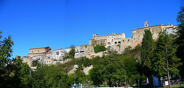
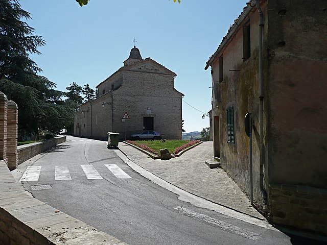
Santa Vittoria in Matenano (Santa Vittoria in Matenano)
.svg)
- Italian comune
 Hiking in Santa Vittoria in Matenano
Santa Vittoria in Matenano is a charming village located in the Marche region of Italy, known for its stunning landscapes and rich history. It's surrounded by beautiful hills, making it a fantastic location for hiking enthusiasts who want to explore nature and enjoy breathtaking views.
Hiking Trails
-
Sentiero dell'Infinito: This is one of the most popular trails around Santa Vittoria. It offers panoramic views of the Sibillini Mountains and the surrounding valleys. The trail is relatively easy and suitable for all skill levels.
-
Monte Ascensione: A more challenging hike, this trail leads you to the summit of Monte Ascensione. From the top, you'll be rewarded with spectacular views of the surrounding landscape. The trail can be steep in places and is best suited for experienced hikers.
-
Historical Trails: There are several trails that feature historical significance, connecting various ancient churches and sites in the area. These hikes not only provide a physical challenge but also an opportunity to learn about the region's history.
Best Time to Hike
The ideal time for hiking in Santa Vittoria in Matenano is during the spring and fall months (April to June and September to October) when the weather is mild and the scenery is particularly beautiful. Summers can be hot, and winter can bring snow to the higher elevations.
Tips for Hiking
- Prepare Adequately: Bring enough water, snacks, and a map or GPS device to navigate the trails.
- Dress Appropriately: Wear proper hiking footwear and layers, as temperatures can vary significantly throughout the day.
- Respect Nature: Stay on designated trails and pack out any trash to help preserve the natural beauty of the area.
- Check Local Conditions: Before heading out, check for any trail closures or local weather conditions that may impact your hike.
Nearby Attractions
After hiking, you can explore the village itself, known for its medieval architecture, quaint streets, and local cuisine. Don’t miss the chance to try local dishes and enjoy the hospitality of the Marche region.
Overall, hiking in and around Santa Vittoria in Matenano offers a wonderful mix of natural beauty, outdoor adventure, and cultural experiences, making it an excellent destination for hikers of all levels.
- Country:

- Postal Code: 63854
- Local Dialing Code: 0734
- Licence Plate Code: FM
- Coordinates: 43° 1' 11" N, 13° 29' 47" E


- GPS tracks (wikiloc): [Link]
- AboveSeaLevel: 626 м m
- Area: 26.18 sq km
- Population: 1322
- Web site: http://www.provincia.ap.it/Santa_Vittoria_in_Matenano/
- Wikipedia en: wiki(en)
- Wikipedia: wiki(it)
- Wikidata storage: Wikidata: Q59296
- Wikipedia Commons Gallery: [Link]
- Wikipedia Commons Category: [Link]
- Freebase ID: [/m/0gl8v_]
- GeoNames ID: Alt: [6540262]
- VIAF ID: Alt: [234773025]
- OSM relation ID: [42268]
- GND ID: Alt: [4535407-8]
- WOEID: [723658]
- TGN ID: [7008904]
- Google Maps Customer ID: [15803870868371078253]
- ISTAT ID: 109036
- Italian cadastre code: I315
Shares border with regions:

Force, Marche
- Italian comune
Hiking in Force, Marche
Force, located in the Marche region of Italy, is a charming hilltop village surrounded by beautiful landscapes that are perfect for hiking enthusiasts. The area is characterized by its rolling hills, forests, and stunning views of the surrounding countryside, making it an excellent destination for outdoor activities....
- Country:
- Postal Code: 63086
- Local Dialing Code: 0736
- Licence Plate Code: AP
- Coordinates: 42° 57' 48" N, 13° 29' 28" E
- GPS tracks (wikiloc): [Link]
- AboveSeaLevel: 689 м m
- Area: 34.31 sq km
- Population: 1278
- Web site: [Link]


Montefalcone Appennino
- Italian comune
Hiking in Montefalcone Appennino
Montefalcone Appennino is a picturesque village located in the Marche region of Italy, nestled in the Sibillini Mountains. It's known for its stunning landscapes, rich history, and diverse hiking opportunities. Here’s an overview of what you can expect when hiking in this area:...
- Country:
- Postal Code: 63855
- Local Dialing Code: 0734
- Licence Plate Code: FM
- Coordinates: 42° 59' 18" N, 13° 27' 32" E
- GPS tracks (wikiloc): [Link]
- AboveSeaLevel: 757 м m
- Area: 15.99 sq km
- Population: 415
- Web site: [Link]
Monteleone di Fermo
- Italian comune
Hiking in Monteleone di Fermo
Monteleone di Fermo is a charming village located in the Marche region of Italy, surrounded by beautiful landscapes ideal for hiking enthusiasts. Here’s an overview of what you can expect when hiking in this area:...
- Country:
- Postal Code: 63841
- Local Dialing Code: 0734
- Licence Plate Code: FM
- Coordinates: 43° 2' 51" N, 13° 31' 43" E
- GPS tracks (wikiloc): [Link]
- AboveSeaLevel: 427 м m
- Area: 8.21 sq km
- Population: 381
- Web site: [Link]


Montelparo
- Italian comune
Hiking in Montelparo
Montelparo is a charming hilltop village located in the Marche region of Italy, surrounded by beautiful landscapes, rolling hills, and rich natural beauty. Hiking in and around Montelparo offers a variety of trails suitable for different experience levels, providing stunning views of the surrounding countryside, vineyards, and distant mountains....
- Country:
- Postal Code: 63853
- Local Dialing Code: 0734
- Licence Plate Code: FM
- Coordinates: 43° 1' 5" N, 13° 32' 7" E
- GPS tracks (wikiloc): [Link]
- AboveSeaLevel: 588 м m
- Area: 21.63 sq km
- Population: 758
- Web site: [Link]


Servigliano
- Italian comune
Hiking in Servigliano
Servigliano is a charming town located in the Marche region of Italy, surrounded by picturesque landscapes that make it an excellent destination for hiking enthusiasts. Here are some aspects to consider if you're thinking about hiking in and around Servigliano:...
- Country:
- Postal Code: 63839
- Local Dialing Code: 0734
- Licence Plate Code: FM
- Coordinates: 43° 4' 51" N, 13° 29' 31" E
- GPS tracks (wikiloc): [Link]
- AboveSeaLevel: 216 м m
- Area: 18.49 sq km
- Population: 2267
- Web site: [Link]

Monte San Martino
- Italian comune
Hiking in Monte San Martino
Monte San Martino, located in the Marche region of Italy, is a fantastic destination for hiking enthusiasts. The area is known for its picturesque landscapes, rolling hills, and rich biodiversity, offering a range of trails suitable for various skill levels....
- Country:
- Postal Code: 62020
- Local Dialing Code: 0733
- Licence Plate Code: MC
- Coordinates: 43° 1' 58" N, 13° 26' 23" E
- GPS tracks (wikiloc): [Link]
- AboveSeaLevel: 603 м m
- Area: 18.47 sq km
- Population: 745
- Web site: [Link]