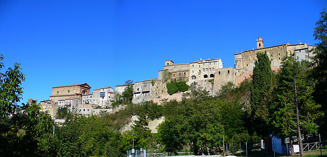
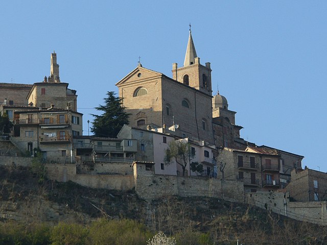
Montelparo (Montelparo)
.svg)
- Italian comune
 Hiking in Montelparo
Montelparo is a charming hilltop village located in the Marche region of Italy, surrounded by beautiful landscapes, rolling hills, and rich natural beauty. Hiking in and around Montelparo offers a variety of trails suitable for different experience levels, providing stunning views of the surrounding countryside, vineyards, and distant mountains.
Key Highlights for Hiking in Montelparo:
-
Trail Variety: The region has numerous hiking trails that range from easy walks to more challenging hikes. You might find trails that take you through forests, vineyards, and olive groves, allowing you to experience the local flora and fauna.
-
Scenic Views: Many trails offer breathtaking panoramic views of the Sibillini Mountains, Adriatic Sea, and the picturesque countryside filled with quaint villages and medieval architecture.
-
Cultural Experience: Hiking in Montelparo provides a unique opportunity to immerse yourself in the local culture. You may encounter historical landmarks, churches, and rural communities along the trails.
-
Wildlife: The area is home to diverse wildlife, so you might spot various birds and other animals during your hike. The natural environment is rich and can be particularly delightful for nature enthusiasts.
-
Local Cuisine: After a day of hiking, you can enjoy traditional Marche cuisine, which includes local specialties like olive all'ascolana (stuffed olives) or homemade pasta, often accompanied by regional wines.
-
Best Season: The best time for hiking in Montelparo is typically from spring to early autumn (April to October), when the weather is mild and the countryside is vibrant and lush.
Popular Hiking Routes:
-
Paths to Nearby Villages: Consider hikes that connect Montelparo with neighboring towns like Santa Vittoria in Matenano or Montefiore dell'Aso. These trails not only offer great exercise but also the chance to explore more of the region's culture.
-
Nature Reserves: Look for paths that lead to nearby nature reserves or parks, such as the Sibillini National Park. This area offers more structured trails and opportunities to witness breathtaking landscapes.
Preparation Tips:
-
Gear: Wear comfortable hiking boots and appropriate clothing for the weather. Bring plenty of water and snacks, especially if you plan on hiking for several hours.
-
Map and Navigation: Having a physical map or a GPS device can help, as some trails may not be well-marked.
-
Local Guides: If you're unfamiliar with the area, consider hiring a local guide who can enhance your experience with knowledge about the trails, history, and culture.
In summary, hiking in Montelparo is a rewarding experience that combines physical activity with the beauty of nature and rich cultural encounters. Enjoy your adventure!
- Country:

- Postal Code: 63853
- Local Dialing Code: 0734
- Licence Plate Code: FM
- Coordinates: 43° 1' 5" N, 13° 32' 7" E


- GPS tracks (wikiloc): [Link]
- AboveSeaLevel: 588 м m
- Area: 21.63 sq km
- Population: 758
- Web site: http://www.comune.montelparo.fm.it/
- Wikipedia en: wiki(en)
- Wikipedia: wiki(it)
- Wikidata storage: Wikidata: Q59269
- Wikipedia Commons Gallery: [Link]
- Wikipedia Commons Category: [Link]
- Freebase ID: [/m/0gl8cx]
- GeoNames ID: Alt: [6538539]
- VIAF ID: Alt: [244779064]
- OSM relation ID: [42267]
- Google Maps Customer ID: [3052319881922578700]
- ISTAT ID: 109020
- Italian cadastre code: F549
Shares border with regions:

Force, Marche
- Italian comune
Hiking in Force, Marche
Force, located in the Marche region of Italy, is a charming hilltop village surrounded by beautiful landscapes that are perfect for hiking enthusiasts. The area is characterized by its rolling hills, forests, and stunning views of the surrounding countryside, making it an excellent destination for outdoor activities....
- Country:
- Postal Code: 63086
- Local Dialing Code: 0736
- Licence Plate Code: AP
- Coordinates: 42° 57' 48" N, 13° 29' 28" E
- GPS tracks (wikiloc): [Link]
- AboveSeaLevel: 689 м m
- Area: 34.31 sq km
- Population: 1278
- Web site: [Link]


Montalto delle Marche
- Italian comune
Hiking in Montalto delle Marche
Montalto delle Marche is a beautiful destination for hiking enthusiasts, located in the Marche region of Italy. This area is characterized by its stunning landscapes, rolling hills, and a rich cultural heritage. Here are some key points to consider if you're planning to hike in and around Montalto delle Marche:...
- Country:
- Postal Code: 63068
- Local Dialing Code: 0736
- Licence Plate Code: AP
- Coordinates: 42° 59' 14" N, 13° 36' 25" E
- GPS tracks (wikiloc): [Link]
- AboveSeaLevel: 512 м m
- Area: 33.94 sq km
- Population: 2078
- Web site: [Link]

Montedinove
- Italian comune
Hiking in Montedinove
Montedinove is a picturesque village located in the Marche region of Italy, known for its stunning landscapes and beautiful hiking trails. Nestled in the hills, it provides a great opportunity to explore the natural beauty of the area, including rolling hills, lush forests, and panoramic views of the surrounding countryside....
- Country:
- Postal Code: 63069
- Local Dialing Code: 0736
- Licence Plate Code: AP
- Coordinates: 42° 58' 14" N, 13° 35' 13" E
- GPS tracks (wikiloc): [Link]
- AboveSeaLevel: 561 м m
- Area: 11.93 sq km
- Population: 498
- Web site: [Link]


Rotella
- Italian comune
Hiking in Rotella
Rotella is a picturesque village located in the province of Fermo, in the Marche region of Italy. Nestled in the rolling hills of the Apennine Mountains, it offers a tranquil environment for hiking enthusiasts. The region is characterized by its beautiful landscapes, rich history, and diverse flora and fauna....
- Country:
- Postal Code: 63071
- Local Dialing Code: 0736
- Licence Plate Code: AP
- Coordinates: 42° 57' 16" N, 13° 33' 39" E
- GPS tracks (wikiloc): [Link]
- AboveSeaLevel: 395 м m
- Area: 27.44 sq km
- Population: 870
- Web site: [Link]
Monsampietro Morico
- Italian comune
Hiking in Monsampietro Morico
Monsampietro Morico is a small, picturesque village located in the Marche region of Italy, known for its beautiful landscapes and hiking opportunities. The surrounding area is characterized by rolling hills, lush forests, and stunning views of the Apennine mountains, making it a great destination for hiking enthusiasts....
- Country:
- Postal Code: 63842
- Local Dialing Code: 0734
- Licence Plate Code: FM
- Coordinates: 43° 4' 3" N, 13° 33' 22" E
- GPS tracks (wikiloc): [Link]
- AboveSeaLevel: 289 м m
- Area: 9.76 sq km
- Population: 637
- Web site: [Link]

Monte Rinaldo
- Italian comune
Hiking in Monte Rinaldo
Monte Rinaldo is part of the Monti Sibillini National Park, located in central Italy, specifically in the Marche region. This area is loved for its stunning landscapes, diverse flora and fauna, and a variety of hiking trails suitable for different levels of experience....
- Country:
- Postal Code: 63852
- Local Dialing Code: 0734
- Licence Plate Code: FM
- Coordinates: 43° 1' 42" N, 13° 34' 51" E
- GPS tracks (wikiloc): [Link]
- AboveSeaLevel: 485 м m
- Area: 8 sq km
- Population: 359
- Web site: [Link]
Monteleone di Fermo
- Italian comune
Hiking in Monteleone di Fermo
Monteleone di Fermo is a charming village located in the Marche region of Italy, surrounded by beautiful landscapes ideal for hiking enthusiasts. Here’s an overview of what you can expect when hiking in this area:...
- Country:
- Postal Code: 63841
- Local Dialing Code: 0734
- Licence Plate Code: FM
- Coordinates: 43° 2' 51" N, 13° 31' 43" E
- GPS tracks (wikiloc): [Link]
- AboveSeaLevel: 427 м m
- Area: 8.21 sq km
- Population: 381
- Web site: [Link]


Santa Vittoria in Matenano
- Italian comune
Hiking in Santa Vittoria in Matenano
Santa Vittoria in Matenano is a charming village located in the Marche region of Italy, known for its stunning landscapes and rich history. It's surrounded by beautiful hills, making it a fantastic location for hiking enthusiasts who want to explore nature and enjoy breathtaking views....
- Country:
- Postal Code: 63854
- Local Dialing Code: 0734
- Licence Plate Code: FM
- Coordinates: 43° 1' 11" N, 13° 29' 47" E
- GPS tracks (wikiloc): [Link]
- AboveSeaLevel: 626 м m
- Area: 26.18 sq km
- Population: 1322
- Web site: [Link]