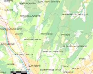
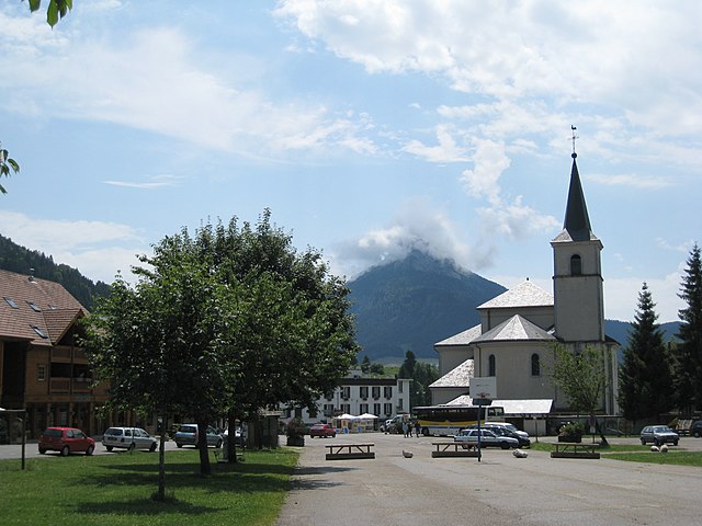
Sarcenas (Sarcenas)

- commune in Isère, France
 Hiking in Sarcenas
Sarcenas, located in the French Alps near Grenoble, is a fantastic destination for hiking enthusiasts. The area offers a variety of trails that cater to different experience levels, from gentle walks to challenging hikes, making it an excellent spot for both beginners and seasoned hikers.
Key Features of Hiking in Sarcenas:
-
Scenic Trails: The trails in Sarcenas offer breathtaking views of the surrounding mountains and valleys. You'll often find stunning vistas, lush forests, and alpine meadows filled with wildflowers, especially during the warmer months.
-
Diversity of Hikes: There are numerous trails in the area. You can choose from short, easy hikes suitable for families to longer, more strenuous hikes for those looking for a challenge. Some of the popular routes include excursions to nearby peaks and panoramic viewpoints.
-
Wildlife and Nature: The region is rich in biodiversity, and hikers might encounter various wildlife species, such as chamois, marmots, and a variety of bird species. The area is also known for its rich flora.
-
Seasonal Considerations: The best time to hike in Sarcenas is from late spring to early fall, typically between May and October, when the weather is milder and trails are accessible. Be cautious of snow or bad weather conditions in early spring or late fall.
-
Local Culture: Hiking in Sarcenas also allows you to experience the local culture and cuisine. Many trails are near small mountain villages where you can sample local delicacies and interact with the friendly locals.
-
Preparation and Safety: It's essential to prepare adequately for hiking in the area. Bring appropriate gear, plenty of water, snacks, and a map or GPS device. Check trail conditions and weather forecasts, and inform someone about your hiking plans.
-
Guided Tours: If you're new to hiking or want to explore the region more comprehensively, consider joining guided hiking tours. Local guides can enhance your experience by sharing insights about the landscape, wildlife, and history of the area.
Recommended Trails:
- Le Col de Vira: A moderate hike that offers stunning views and a chance to experience the alpine environment.
- La Dent de Crolles: A more challenging hike that rewards with panoramic views at the summit.
- The Plateau of l’Aiguille: A family-friendly hike that features beautiful landscapes and is well-marked.
Whether you're looking for an adventurous trek or a peaceful walk in nature, Sarcenas has something to offer every hiker. Always be sure to check local guidelines and trail maps for the best and safest experience.
- Country:

- Postal Code: 38700
- Coordinates: 45° 16' 26" N, 5° 45' 29" E


- GPS tracks (wikiloc): [Link]
- Area: 7.76 sq km
- Population: 196
- Web site: http://www.sarcenas.com
- Wikipedia en: wiki(en)
- Wikipedia: wiki(fr)
- Wikidata storage: Wikidata: Q920497
- Wikipedia Commons Category: [Link]
- Freebase ID: [/m/03nvkw3]
- GeoNames ID: Alt: [6433407]
- SIREN number: [213804727]
- BnF ID: [15258278n]
- INSEE municipality code: 38472
Shares border with regions:


Quaix-en-Chartreuse
- commune in Isère, France
Hiking in Quaix-en-Chartreuse
Hiking in Quaix-en-Chartreuse, located in the Chartreuse mountain range of France, offers stunning landscapes, diverse trails, and a rich natural heritage. Here are some key highlights for hikers in the area:...
- Country:
- Postal Code: 38950
- Coordinates: 45° 15' 10" N, 5° 43' 7" E
- GPS tracks (wikiloc): [Link]
- AboveSeaLevel: 525 м m
- Area: 18.09 sq km
- Population: 906
- Web site: [Link]


Le Sappey-en-Chartreuse
- commune in Isère, France
Hiking in Le Sappey-en-Chartreuse
Le Sappey-en-Chartreuse is a charming village located in the Chartreuse mountain range of the French Alps. This region is known for its stunning natural landscapes, rich biodiversity, and a variety of outdoor activities, making it an excellent destination for hiking enthusiasts. Here are some highlights for hiking in Le Sappey-en-Chartreuse:...
- Country:
- Postal Code: 38700
- Coordinates: 45° 15' 45" N, 5° 46' 41" E
- GPS tracks (wikiloc): [Link]
- Area: 15.13 sq km
- Population: 1119

Proveysieux
- commune in Isère, France
Hiking in Proveysieux
Proveysieux is a charming village located in the Grenoble area of the French Alps. It's a fantastic destination for hiking enthusiasts looking to explore the natural beauty of the region. Here are some key points about hiking in Proveysieux:...
- Country:
- Postal Code: 38120
- Coordinates: 45° 15' 46" N, 5° 41' 58" E
- GPS tracks (wikiloc): [Link]
- Area: 20.37 sq km
- Population: 503

Saint-Pierre-de-Chartreuse
- commune in Isère, France
Hiking in Saint-Pierre-de-Chartreuse
Saint-Pierre-de-Chartreuse is a picturesque village located in the Chartreuse Mountains, in the Auvergne-Rhône-Alpes region of France. It's a popular destination for outdoor enthusiasts, particularly hikers, due to its stunning landscapes, diverse trails, and rich natural heritage. Here are some highlights and tips for hiking in this beautiful area:...
- Country:
- Postal Code: 38380
- Coordinates: 45° 20' 33" N, 5° 48' 56" E
- GPS tracks (wikiloc): [Link]
- Area: 80.12 sq km
- Population: 1028
- Web site: [Link]