Sarstedt (Sarstedt)
- municipality of Germany
Sarstedt, located in the Lower Saxony region of Germany, offers a variety of hiking opportunities that are great for both novice and experienced hikers. While the immediate area may not have the dramatic landscapes found in other parts of Germany, it provides a charming environment with scenic trails and beautiful natural surroundings.
Key Features of Hiking in Sarstedt:
-
Scenic Trails: The region features several well-marked hiking trails that meander through forests, fields, and along the River Innerste. These trails often provide a peaceful setting where you can enjoy the local flora and fauna.
-
Nearby Nature Reserves: Not far from Sarstedt, you can explore nature reserves and parks that offer more extensive hiking opportunities. The nearby Harz National Park is a bit further away but is great for a day trip, offering more challenging trails and stunning views.
-
Local Parks: Sarstedt itself may have smaller parks and natural areas suitable for short walks and family hikes. Parks like the nearby "Hain" or local green spaces can be good for leisurely strolls.
-
Cultural Heritage: As you hike in and around Sarstedt, you may encounter historical landmarks and cultural sites, such as quaint villages and old churches, that can add an interesting element to your hike.
-
Accessibility: The trails around Sarstedt tend to be easily accessible, making them suitable for families as well as casual hikers. Information about local trails can often be found at tourist information centers or local hiking clubs.
Tips for Hiking in Sarstedt:
-
Appropriate Gear: Wear comfortable hiking shoes and pack essentials such as water, snacks, and a map or GPS device.
-
Weather Considerations: Check the weather forecast before your hike, as conditions can change, especially in early spring or late autumn.
-
Respect Nature: Follow the Leave No Trace principles by staying on marked trails, packing out what you bring in, and being considerate of wildlife.
-
Stay Informed: If you're looking for more specific trails or hiking groups, consider using local hiking apps or websites that review trails and provide maps.
In summary, while Sarstedt may not be a heavyweight destination for hiking, it has its own charm and offers a variety of enjoyable trails and natural beauty. For a more robust hiking adventure, consider exploring the wider Lower Saxony region or nearby national parks.
- Country:

- Postal Code: 31157
- Local Dialing Code: 05066
- Licence Plate Code: HI
- Coordinates: 52° 14' 22" N, 9° 51' 38" E


- GPS tracks (wikiloc): [Link]
- AboveSeaLevel: 64 м m
- Area: 42.94 sq km
- Population: 19262
- Web site: http://www.sarstedt.de
- Wikipedia en: wiki(en)
- Wikipedia: wiki(de)
- Wikidata storage: Wikidata: Q558620
- Wikipedia Commons Category: [Link]
- Freebase ID: [/m/05_2x6]
- Freebase ID: [/m/05_2x6]
- GeoNames ID: Alt: [2841386]
- GeoNames ID: Alt: [2841386]
- VIAF ID: Alt: [143124944]
- VIAF ID: Alt: [143124944]
- OSM relation ID: [90874]
- OSM relation ID: [90874]
- GND ID: Alt: [4051714-7]
- GND ID: Alt: [4051714-7]
- archINFORM location ID: [11910]
- archINFORM location ID: [11910]
- Library of Congress authority ID: Alt: [n85002112]
- Library of Congress authority ID: Alt: [n85002112]
- MusicBrainz area ID: [1597879d-e914-4e02-9ebc-5ad0cdbac4b6]
- MusicBrainz area ID: [1597879d-e914-4e02-9ebc-5ad0cdbac4b6]
- WOEID: [691070]
- WOEID: [691070]
- Historical Gazetteer (GOV) ID: [SAREDTJO42WF]
- Historical Gazetteer (GOV) ID: [SAREDTJO42WF]
- EMLO location ID: [8582b453-e80d-4211-ab59-08ad8f54fc40]
- EMLO location ID: [8582b453-e80d-4211-ab59-08ad8f54fc40]
- German municipality key: 03254028
- German municipality key: 03254028
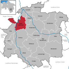
Shares border with regions:


Laatzen
- town in the district of Hanover, in Lower Saxony, Germany
Laatzen, located in Lower Saxony, Germany, offers access to several beautiful hiking opportunities, particularly within the surrounding areas, such as the nearby Hannover region and various trails in natural reserves. Here are some key points to consider if you're interested in hiking in or around Laatzen:...
- Country:

- Postal Code: 30880
- Local Dialing Code: 0511; 05102
- Licence Plate Code: H
- Coordinates: 52° 19' 0" N, 9° 48' 0" E


- GPS tracks (wikiloc): [Link]
- AboveSeaLevel: 46 м m
- Area: 34.05 sq km
- Population: 40939
- Web site: [Link]


Pattensen
- town in the Region of Hannover, Lower Saxony, Germany
Pattensen is a small town located near Hanover in Lower Saxony, Germany. While it may not be as popular as some larger hiking destinations, it offers access to beautiful trails and landscapes in the surrounding areas. Here are some highlights and tips for hiking in and around Pattensen:...
- Country:

- Postal Code: 30982
- Local Dialing Code: 05102; 05101; 05069; 05066
- Licence Plate Code: H
- Coordinates: 52° 15' 52" N, 9° 45' 52" E


- GPS tracks (wikiloc): [Link]
- AboveSeaLevel: 67 м m
- Area: 67 sq km
- Population: 14630
- Web site: [Link]


Harsum
- municipality of Germany
Harsum, located in Lower Saxony, Germany, is a charming area that offers various outdoor activities, including hiking. While it may not be as well-known as some larger hiking destinations, there are several trails and natural areas worth exploring....
- Country:

- Postal Code: 31177
- Local Dialing Code: 05128; 05127
- Licence Plate Code: HI
- Coordinates: 52° 12' 0" N, 9° 57' 0" E


- GPS tracks (wikiloc): [Link]
- AboveSeaLevel: 70 м m
- Area: 49.93 sq km
- Population: 11367
- Web site: [Link]


Nordstemmen
- municipality of Germany
Nordstemmen is a small town in Lower Saxony, Germany, located near the larger city of Hannover. While it may not be as widely recognized as hiking destinations like the Harz Mountains, there are still excellent hiking opportunities in and around this area....
- Country:

- Postal Code: 31171
- Local Dialing Code: 05069
- Licence Plate Code: HI
- Coordinates: 52° 9' 43" N, 9° 47' 1" E


- GPS tracks (wikiloc): [Link]
- AboveSeaLevel: 76 м m
- Area: 60.17 sq km
- Population: 12119
- Web site: [Link]


Algermissen
- municipality of Germany
Algermissen is a small municipality located in Lower Saxony, Germany. While it may not be as well-known for hiking as larger natural parks or mountainous regions, there are still opportunities for outdoor activities in and around the area....
- Country:

- Postal Code: 31191
- Local Dialing Code: 05126
- Licence Plate Code: HI
- Coordinates: 52° 15' 12" N, 9° 58' 9" E


- GPS tracks (wikiloc): [Link]
- AboveSeaLevel: 79 м m
- Area: 35.62 sq km
- Population: 7840
- Web site: [Link]


Giesen
- municipality of Germany
Giesen, located in Lower Saxony, Germany, is a great spot for hiking enthusiasts. The region is characterized by its natural beauty, with lush forests, rolling hills, and the nearby Leine River, which offers picturesque landscapes....
- Country:

- Postal Code: 31180
- Local Dialing Code: 05121; 05066
- Licence Plate Code: HI
- Coordinates: 52° 12' 0" N, 9° 53' 0" E


- GPS tracks (wikiloc): [Link]
- AboveSeaLevel: 70 м m
- Area: 33.90 sq km
- Population: 9698
- Web site: [Link]

