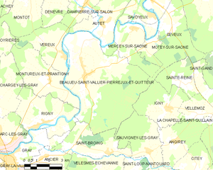
Sauvigney-lès-Gray (Sauvigney-lès-Gray)

- commune in Haute-Saône, France
- Country:

- Postal Code: 70100
- Coordinates: 47° 26' 50" N, 5° 44' 28" E


- GPS tracks (wikiloc): [Link]
- AboveSeaLevel: 200 м m
- Area: 10.44 sq km
- Population: 107
- Wikipedia en: wiki(en)
- Wikipedia: wiki(fr)
- Wikidata storage: Wikidata: Q902277
- Wikipedia Commons Category: [Link]
- Freebase ID: [/m/03nvsnd]
- GeoNames ID: Alt: [6617499]
- SIREN number: [217004795]
- BnF ID: [15272871v]
- PACTOLS thesaurus ID: [pcrtJDEFMckr1W]
- INSEE municipality code: 70479
Shares border with regions:


Angirey
- commune in Haute-Saône, France
- Country:
- Postal Code: 70700
- Coordinates: 47° 27' 19" N, 5° 46' 2" E
- GPS tracks (wikiloc): [Link]
- AboveSeaLevel: 229.0 м m
- Area: 8.87 sq km
- Population: 137

Beaujeu-Saint-Vallier-Pierrejux-et-Quitteur
- commune in Haute-Saône, France
- Country:
- Postal Code: 70100
- Coordinates: 47° 30' 17" N, 5° 40' 34" E
- GPS tracks (wikiloc): [Link]
- Area: 35.12 sq km
- Population: 927


Choye
- commune in Haute-Saône, France
- Country:
- Postal Code: 70700
- Coordinates: 47° 23' 28" N, 5° 45' 35" E
- GPS tracks (wikiloc): [Link]
- Area: 14.4 sq km
- Population: 441

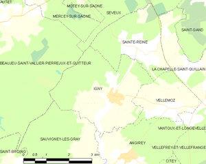
Igny
- commune in Haute-Saône, France
- Country:
- Postal Code: 70700
- Coordinates: 47° 28' 44" N, 5° 45' 44" E
- GPS tracks (wikiloc): [Link]
- Area: 10.03 sq km
- Population: 184
Saint-Broing
- commune in Haute-Saône, France
- Country:
- Postal Code: 70100
- Coordinates: 47° 26' 57" N, 5° 41' 53" E
- GPS tracks (wikiloc): [Link]
- Area: 10.17 sq km
- Population: 114


Saint-Loup-Nantouard
- commune in Haute-Saône, France
- Country:
- Postal Code: 70100
- Coordinates: 47° 25' 31" N, 5° 43' 30" E
- GPS tracks (wikiloc): [Link]
- Area: 7.64 sq km
- Population: 107