Savignano sul Panaro (Savignano sul Panaro)
- Italian comune
 Hiking in Savignano sul Panaro
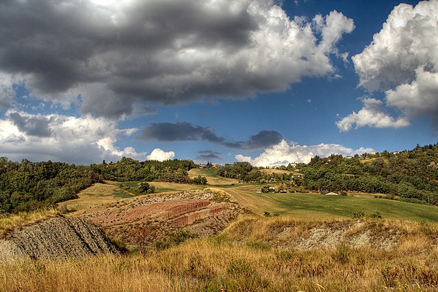
Savignano sul Panaro is a charming town located in the Emilia-Romagna region of Italy, nestled in a picturesque valley surrounded by hills and nature. Hiking in and around Savignano sul Panaro provides an excellent opportunity to explore the beautiful landscapes, scenic views, and rich history of the area.
Hiking Trails:
-
Monte Pizzo: This is a popular hiking destination close to Savignano sul Panaro. The trail to the summit offers stunning panoramic views of the surrounding hills and valleys. The hike can vary in difficulty, so it’s suitable for both beginners and more experienced hikers.
-
Tizzano Valley: The trails in this valley offer a mix of gentle walks and more challenging routes, allowing hikers to explore the diverse flora and fauna of the region. The paths often wind through vineyards and orchards, showcasing the agricultural heritage of the area.
-
Gole del Dolo: This beautiful gorge is a little further afield but offers dramatic scenery and interesting rock formations. The trail is more rugged and suited for those looking for a bit of adventure.
Tips for Hiking in Savignano sul Panaro:
- Check Weather Conditions: The weather can change quickly, especially in mountainous areas. Make sure to check the forecast and dress accordingly.
- Stay Hydrated: Carry enough water, especially on hotter days, as some trails can be remote with limited access to water sources.
- Footwear: Wear sturdy hiking boots or shoes suitable for trails, as many paths can be uneven or rocky.
- Trail Maps: It’s advisable to have a physical map or a reliable hiking app to navigate, as signposting can vary.
- Local Knowledge: Consider reaching out to local hiking clubs or guides for advice on the best trails or organized hikes.
Attractions:
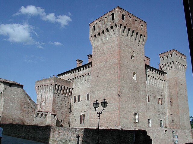
In addition to hiking, Savignano sul Panaro has historical and cultural attractions. The town features beautiful architecture, local cuisine to try, and the chance to explore traditional Italian life in a less touristy setting.
Whether you’re looking for a peaceful hike, stunning views, or a cultural experience, Savignano sul Panaro offers a little bit of everything for outdoor enthusiasts. Enjoy your adventure!
- Country:

- Postal Code: 41056
- Local Dialing Code: 059
- Licence Plate Code: MO
- Coordinates: 44° 29' 0" N, 11° 2' 0" E


- GPS tracks (wikiloc): [Link]
- AboveSeaLevel: 202 м m
- Area: 25.55 sq km
- Population: 9142
- Web site: http://www.savignano.it
- Wikipedia en: wiki(en)
- Wikipedia: wiki(it)
- Wikidata storage: Wikidata: Q100104
- Wikipedia Commons Category: [Link]
- Freebase ID: [/m/0gkgvc]
- GeoNames ID: Alt: [6538459]
- VIAF ID: Alt: [126415614]
- OSM relation ID: [43170]
- UN/LOCODE: [ITSSP]
- ISTAT ID: 036041
- Italian cadastre code: I473
Shares border with regions:


Guiglia
- Italian comune
Guiglia is a charming town located in the Emilia-Romagna region of Italy, nestled in the foothills of the Apennines. It offers a variety of hiking opportunities for outdoor enthusiasts. Here are some highlights of hiking in and around Guiglia:...
- Country:

- Postal Code: 41052
- Local Dialing Code: 059
- Licence Plate Code: MO
- Coordinates: 44° 25' 30" N, 10° 57' 47" E


- GPS tracks (wikiloc): [Link]
- AboveSeaLevel: 490 м m
- Area: 48.3 sq km
- Population: 3910
- Web site: [Link]
Marano sul Panaro
- Italian comune
Marano sul Panaro is a charming town located in the Emilia-Romagna region of Italy, surrounded by beautiful landscapes that are ideal for hiking enthusiasts. The area is characterized by rolling hills, vineyards, and extensive woodlands, making it an excellent destination for outdoor activities....
- Country:

- Postal Code: 41054
- Local Dialing Code: 059
- Licence Plate Code: MO
- Coordinates: 44° 27' 26" N, 10° 58' 19" E


- GPS tracks (wikiloc): [Link]
- AboveSeaLevel: 142 м m
- Area: 45.47 sq km
- Population: 5167
- Web site: [Link]


San Cesario sul Panaro
- Italian comune
 Hiking in San Cesario sul Panaro
San Cesario sul Panaro is a charming town located in the Emilia-Romagna region of Italy, not far from the city of Modena. While it's not as widely known for hiking as some other areas in Italy, it still offers beautiful landscapes and opportunities for outdoor activities, including hiking....
- Country:

- Postal Code: 41018
- Local Dialing Code: 059
- Licence Plate Code: MO
- Coordinates: 44° 34' 0" N, 11° 2' 0" E


- GPS tracks (wikiloc): [Link]
- AboveSeaLevel: 54 м m
- Area: 27.31 sq km
- Population: 6460
- Web site: [Link]
Spilamberto
- Italian comune
Spilamberto, located in the Emilia-Romagna region of Italy, is a charming town that offers various outdoor activities, including hiking. While Spilamberto itself is known for its historic town center and local cuisine, the surrounding area features beautiful landscapes, vineyards, and hills that are perfect for hiking enthusiasts....
- Country:

- Postal Code: 41057
- Local Dialing Code: 059
- Licence Plate Code: MO
- Coordinates: 44° 32' 0" N, 11° 1' 0" E


- GPS tracks (wikiloc): [Link]
- AboveSeaLevel: 70 м m
- Area: 29.79 sq km
- Population: 12767
- Web site: [Link]


Vignola
- Italian comune
Vignola, a charming town in the Emilia-Romagna region of Italy, is surrounded by picturesque landscapes and hiking opportunities, particularly along the Apennine Mountains. Here are some highlights for hiking in and around Vignola:...
- Country:

- Postal Code: 41058
- Local Dialing Code: 059
- Licence Plate Code: MO
- Coordinates: 44° 28' 51" N, 11° 0' 8" E


- GPS tracks (wikiloc): [Link]
- AboveSeaLevel: 125 м m
- Area: 22.86 sq km
- Population: 25313
- Web site: [Link]
Bazzano
- settlement in the italian municipality of Valsamoggia
Bazzano, a small town located in the Emilia-Romagna region of Italy, is often appreciated for its picturesque countryside and proximity to the Apennine Mountains. While it may not be as widely known as larger hiking destinations, it offers access to several trails that provide beautiful views and a chance to experience the rich natural environment of the area....
- Country:

- Postal Code: 40053
- Local Dialing Code: 051
- Licence Plate Code: BO
- Coordinates: 44° 30' 11" N, 11° 5' 11" E


- GPS tracks (wikiloc): [Link]
- AboveSeaLevel: 93 м m
- Area: 13.99 sq km
- Web site: [Link]
Castello di Serravalle
- Italian comune
 Hiking in Castello di Serravalle
Castello di Serravalle is a quaint village in the Emilia-Romagna region of Italy, situated on a hilltop that offers stunning views of the surrounding countryside. The area is known for its beautiful landscapes, rich history, and a network of hiking trails that are perfect for outdoor enthusiasts....
- Country:

- Postal Code: 40050
- Local Dialing Code: 051
- Licence Plate Code: BO
- Coordinates: 44° 26' 16" N, 11° 1' 50" E


- GPS tracks (wikiloc): [Link]
- AboveSeaLevel: 182 м m
- Area: 39.24 sq km
- Web site: [Link]


Monteveglio
- Italian comune
Monteveglio, located in the Emilia-Romagna region of northern Italy, is known for its beautiful landscapes, vineyards, and rich history. The area is part of the Contra del Parco Regionale dell'Abbazia di Monteveglio, which features numerous hiking trails that offer stunning views and opportunities to explore the local flora and fauna....
- Country:

- Postal Code: 40050
- Local Dialing Code: 051
- Licence Plate Code: BO
- Coordinates: 44° 28' 7" N, 11° 5' 28" E


- GPS tracks (wikiloc): [Link]
- AboveSeaLevel: 114 м m
- Area: 32.57 sq km
- Web site: [Link]
