Castello di Serravalle (Castello di Serravalle)
- Italian comune
 Hiking in Castello di Serravalle
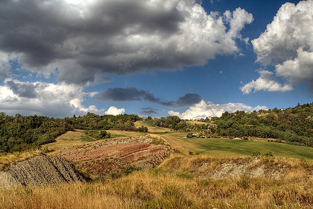
Castello di Serravalle is a quaint village in the Emilia-Romagna region of Italy, situated on a hilltop that offers stunning views of the surrounding countryside. The area is known for its beautiful landscapes, rich history, and a network of hiking trails that are perfect for outdoor enthusiasts.
Hiking Trails
-
Promenade of the Castle: A popular route that allows hikers to explore the castle's fortifications and the scenic views of the valleys below. The trail often leads you through vineyards and olive groves, providing a glimpse of traditional Italian agriculture.
-
Monte delle Formiche: This trail takes you up to Monte delle Formiche, offering panoramic views of the Apennines. The trail is moderately challenging and ideal for those looking to soak in nature and enjoy the local flora and fauna.
-
Natural Reserves: The surrounding areas are often rich in natural reserves and parks, where you can discover local wildlife and diverse ecosystems. Check out the Regional Park of Sassi di Roccamalatina, which is not too far away and offers a variety of trails.
What to Expect
- Scenic Views: Expect breathtaking views of rolling hills, vineyards, and ancient castles throughout your hike.
- Historical Sites: Along the trails, you may come across ancient ruins, historical farms, and charming villages.
- Local Flora and Fauna: Depending on the season, you can encounter a variety of wildflowers, birds, and interesting forest wildlife.
Tips for Hikers
- Best Time to Visit: Spring (April to June) and fall (September to October) are ideal for hiking when the weather is mild, and the scenery is at its best.
- Gear Up: Wear comfortable hiking shoes and bring enough water, snacks, and a camera because the views can be spectacular.
- Check Trail Conditions: Before heading out, it’s advisable to check the trail conditions and weather. Local tourism offices or hiking clubs can provide valuable information.
- Respect the Environment: Stay on marked paths, pack out what you pack in, and respect wildlife.
Hiking in and around Castello di Serravalle provides a great opportunity to enjoy nature while experiencing the rich culture and history of this beautiful region of Italy. Whether you are a seasoned hiker or a beginner, there are trails suitable for all levels. Happy hiking!
- Country:

- Postal Code: 40050
- Local Dialing Code: 051
- Licence Plate Code: BO
- Coordinates: 44° 26' 16" N, 11° 1' 50" E


- GPS tracks (wikiloc): [Link]
- AboveSeaLevel: 182 м m
- Area: 39.24 sq km
- Web site: http://www.comunecastellucchio.it
- Wikipedia en: wiki(en)
- Wikipedia: wiki(it)
- Wikidata storage: Wikidata: Q94785
- Wikipedia Commons Category: [Link]
- Freebase ID: [/m/0gkh8x]
- GeoNames ID: Alt: [6536349]
- WOEID: [713395]
- UN/LOCODE: [ITZBT]
- ISTAT ID: 037018
- Italian cadastre code: C191
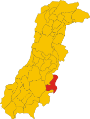
Shares border with regions:


Guiglia
- Italian comune
Guiglia is a charming town located in the Emilia-Romagna region of Italy, nestled in the foothills of the Apennines. It offers a variety of hiking opportunities for outdoor enthusiasts. Here are some highlights of hiking in and around Guiglia:...
- Country:

- Postal Code: 41052
- Local Dialing Code: 059
- Licence Plate Code: MO
- Coordinates: 44° 25' 30" N, 10° 57' 47" E


- GPS tracks (wikiloc): [Link]
- AboveSeaLevel: 490 м m
- Area: 48.3 sq km
- Population: 3910
- Web site: [Link]
Savignano sul Panaro
- Italian comune
 Hiking in Savignano sul Panaro
Savignano sul Panaro is a charming town located in the Emilia-Romagna region of Italy, nestled in a picturesque valley surrounded by hills and nature. Hiking in and around Savignano sul Panaro provides an excellent opportunity to explore the beautiful landscapes, scenic views, and rich history of the area....
- Country:

- Postal Code: 41056
- Local Dialing Code: 059
- Licence Plate Code: MO
- Coordinates: 44° 29' 0" N, 11° 2' 0" E


- GPS tracks (wikiloc): [Link]
- AboveSeaLevel: 202 м m
- Area: 25.55 sq km
- Population: 9142
- Web site: [Link]


Zocca
- Italian comune
Hiking in Zocca, a picturesque town located in the Apennine Mountains of Italy, offers a wonderful opportunity for outdoor enthusiasts to explore the lush landscapes, rolling hills, and stunning views of the region. Zocca is known for its natural beauty, with trails that vary in difficulty, making it accessible for hikers of all levels....
- Country:

- Postal Code: 41059
- Local Dialing Code: 059
- Licence Plate Code: MO
- Coordinates: 44° 20' 44" N, 10° 59' 35" E


- GPS tracks (wikiloc): [Link]
- AboveSeaLevel: 759 м m
- Area: 69.37 sq km
- Population: 4608
- Web site: [Link]
Monte San Pietro
- Italian comune
Monte San Pietro, located in the Emilia-Romagna region of Italy, offers a variety of hiking opportunities for outdoor enthusiasts. The area is characterized by its beautiful landscapes, rolling hills, and picturesque views, making it an ideal spot for both casual walkers and experienced hikers....
- Country:

- Postal Code: 40050
- Local Dialing Code: 051
- Licence Plate Code: BO
- Coordinates: 44° 26' 19" N, 11° 8' 3" E


- GPS tracks (wikiloc): [Link]
- AboveSeaLevel: 112 м m
- Area: 74.69 sq km
- Population: 10960
- Web site: [Link]


Monteveglio
- Italian comune
Monteveglio, located in the Emilia-Romagna region of northern Italy, is known for its beautiful landscapes, vineyards, and rich history. The area is part of the Contra del Parco Regionale dell'Abbazia di Monteveglio, which features numerous hiking trails that offer stunning views and opportunities to explore the local flora and fauna....
- Country:

- Postal Code: 40050
- Local Dialing Code: 051
- Licence Plate Code: BO
- Coordinates: 44° 28' 7" N, 11° 5' 28" E


- GPS tracks (wikiloc): [Link]
- AboveSeaLevel: 114 м m
- Area: 32.57 sq km
- Web site: [Link]
Savigno
- Italian comune
Savigno, a charming village in the province of Bologna, Italy, is known for its beautiful landscapes and picturesque countryside, making it an excellent destination for hiking enthusiasts. The area is characterized by rolling hills, lush vineyards, and ancient woods, offering a variety of trails suitable for different skill levels....
- Country:

- Postal Code: 40060
- Local Dialing Code: 051
- Licence Plate Code: BO
- Coordinates: 44° 24' 0" N, 11° 5' 0" E


- GPS tracks (wikiloc): [Link]
- AboveSeaLevel: 259 м m
- Area: 54.84 sq km
- Web site: [Link]
