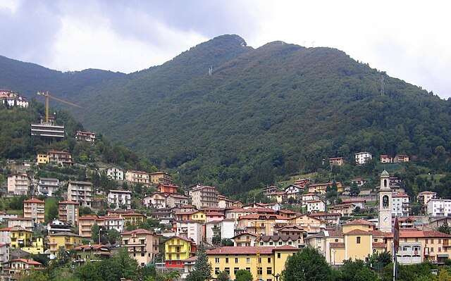
Sedrina (Sedrina)
.svg)
- Italian comune
 Hiking in Sedrina
Sedrina, a charming locality in the province of Bergamo in Italy, offers beautiful hiking opportunities amidst the stunning backdrop of the Italian Alps. Here are some highlights and suggestions if you're considering hiking in the area:
1.
Sedrina is surrounded by natural beauty, featuring a mix of wooded areas, hills, and panoramic views of the surrounding mountains. Popular trails often lead to higher vantage points, where you can enjoy sweeping views of Lake Como and the Bergamo Valley.
2.
You can find trails suitable for all levels of hikers, from easy walks perfect for families to more strenuous hikes for seasoned adventurers. Make sure to assess your fitness level and choose a trail that matches it.
3.
While hiking, keep an eye out for local flora and fauna. The region is home to diverse wildlife and picturesque landscapes. Hiking during the spring can provide lovely wildflower views, while fall showcases beautiful autumn foliage.
4.
Some hiking trails in the Sedrina area may lead to historical sites, such as chapels, ancient ruins, and traditional stone villages. These not only enhance your hiking experience but also give you insight into the local culture.
5.
Weather can change rapidly in mountainous areas. It’s important to check forecasts before your hike, dress in layers, and carry rain gear if necessary.
6.
As with any hiking location, always inform someone about your hiking plans, carry a map or GPS device, and bring sufficient water and snacks. Additionally, familiarize yourself with any local regulations or guidelines for the area.
7.
If you're unfamiliar with the area or prefer a structured experience, consider joining a guided hiking tour. Local guides can provide invaluable insights and ensure that you have a safe and enjoyable experience.
Always remember to follow Leave No Trace principles to help preserve the natural beauty of Sedrina for future hikers. Enjoy your adventure in this beautiful part of Italy!
- Country:

- Postal Code: 24010
- Local Dialing Code: 0345
- Licence Plate Code: BG
- Coordinates: 45° 46' 55" N, 9° 37' 25" E


- GPS tracks (wikiloc): [Link]
- AboveSeaLevel: 328 м m
- Area: 5.85 sq km
- Population: 2465
- Web site: http://www.comune.sedrina.bg.it/
- Wikipedia en: wiki(en)
- Wikipedia: wiki(it)
- Wikidata storage: Wikidata: Q101569
- Wikipedia Commons Gallery: [Link]
- Wikipedia Commons Category: [Link]
- Freebase ID: [/m/0gjdt2]
- GeoNames ID: Alt: [6537156]
- VIAF ID: Alt: [156207669]
- OSM relation ID: [46052]
- UN/LOCODE: [ITDR9]
- ISTAT ID: 016196
- Italian cadastre code: I567
Shares border with regions:


Sorisole
- Italian comune
Hiking in Sorisole
Sorisole, located in the Lombardy region of Italy, is a beautiful destination for hiking enthusiasts. Nestled in the foothills of the Alps, it offers a range of trails that vary in difficulty, making it suitable for both beginners and experienced hikers....
- Country:
- Postal Code: 24010
- Local Dialing Code: 035
- Licence Plate Code: BG
- Coordinates: 45° 44' 15" N, 9° 39' 23" E
- GPS tracks (wikiloc): [Link]
- AboveSeaLevel: 415 м m
- Area: 12.25 sq km
- Population: 9042
- Web site: [Link]

Ubiale Clanezzo
- Italian comune
Hiking in Ubiale Clanezzo
Ubiale Clanezzo is a picturesque area located in the province of Bergamo, in Lombardy, Italy. This region is known for its beautiful landscapes, lush forests, and charming villages, making it a great destination for hiking enthusiasts....
- Country:
- Postal Code: 24010
- Local Dialing Code: 0345
- Licence Plate Code: BG
- Coordinates: 45° 47' 0" N, 9° 37' 0" E
- GPS tracks (wikiloc): [Link]
- AboveSeaLevel: 336 м m
- Area: 7.35 sq km
- Population: 1377
- Web site: [Link]


Villa d'Almè
- Italian comune
Hiking in Villa d'Almè
Villa d'Almè is a charming town located in the province of Bergamo in northern Italy, surrounded by beautiful landscapes that are ideal for hiking enthusiasts. Nestled in the foothills of the Italian Alps, Villa d'Almè offers a variety of trails suitable for different skill levels, from easy walks to more challenging hikes....
- Country:
- Postal Code: 24018
- Local Dialing Code: 035
- Licence Plate Code: BG
- Coordinates: 45° 45' 0" N, 9° 37' 0" E
- GPS tracks (wikiloc): [Link]
- AboveSeaLevel: 300 м m
- Area: 6.49 sq km
- Population: 6672
- Web site: [Link]


Zogno
- Italian comune
Hiking in Zogno
Zogno is a charming village located in the province of Bergamo, Lombardy, Italy. Nestled in the Seriana Valley, it offers stunning landscapes, rich history, and a variety of hiking trails that cater to different skill levels. Here’s an overview of what you can expect when hiking in Zogno:...
- Country:
- Postal Code: 24019
- Local Dialing Code: 0345
- Licence Plate Code: BG
- Coordinates: 45° 47' 38" N, 9° 39' 56" E
- GPS tracks (wikiloc): [Link]
- AboveSeaLevel: 334 м m
- Area: 35.21 sq km
- Population: 8926
- Web site: [Link]