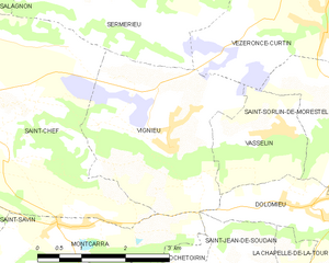
Sermérieu (Sermérieu)

- commune in Isère, France
 Hiking in Sermérieu
Sermérieu is a small commune located in the Isère department of southeastern France. Nestled in a picturesque part of the Rhône-Alpes region, it offers several opportunities for hiking and enjoying the outdoors. Here are some things to know about hiking in and around Sermérieu:
Trail Options
-
Local Trails: While specific trails within Sermérieu may not be as famous as those in larger national parks, the surrounding area has a network of paths suitable for various hiking levels. You can expect charming countryside walks with glimpses of local flora and fauna.
-
Proximity to Larger Hiking Areas: Sermérieu is relatively close to the Chartreuse and Vercors Massifs, which boast more extensive and challenging trails. If you're looking to extend your hiking adventure, these areas offer a wide range of trails with stunning views.
Hiking Tips
- Seasonal Considerations: Spring and early fall are ideal times for hiking in this region due to mild weather. Summers can be warm, so early morning hikes are recommended.
- Preparation: Ensure that you have appropriate footwear, plenty of water, and snacks. A map or GPS device can be helpful, as some trails might not be well-marked.
- Local Regulations: Respect local nature conservation rules and stay on marked paths to help preserve the environment.
Scenic Highlights
- Natural Beauty: The region is characterized by rolling hills, wooded areas, and agricultural landscapes, providing a peaceful hiking experience. Look for panoramic viewpoints that may offer stunning views of the surrounding countryside.
- Wildlife: Keep an eye out for local wildlife, which can include various bird species and small mammals.
Community and Culture
Exploring the local culture can enhance your hiking experience. Consider visiting local markets or dining at local eateries to enjoy regional cuisine.
Overall, hiking in Sermérieu can be a delightful experience, especially if you combine it with visits to the surrounding natural parks. Whether you are a beginner or an experienced hiker, you'll find scenic spots to explore and enjoy!
- Country:

- Postal Code: 38510
- Coordinates: 45° 40' 17" N, 5° 24' 35" E


- GPS tracks (wikiloc): [Link]
- Area: 17.14 sq km
- Population: 1640
- Web site: http://www.sermerieu.fr
- Wikipedia en: wiki(en)
- Wikipedia: wiki(fr)
- Wikidata storage: Wikidata: Q1067682
- Wikipedia Commons Category: [Link]
- Freebase ID: [/m/03nvkv2]
- GeoNames ID: Alt: [6433414]
- SIREN number: [213804834]
- INSEE municipality code: 38483
Shares border with regions:

Vignieu
- commune in Isère, France
Hiking in Vignieu
Vignieu is a charming commune located in the Isère department in the Auvergne-Rhône-Alpes region of southeastern France. While it might not be as well-known as some other hiking destinations in France, it offers picturesque landscapes and a range of outdoor activities that can cater to hikers of various skill levels....
- Country:
- Postal Code: 38890
- Coordinates: 45° 37' 41" N, 5° 25' 29" E
- GPS tracks (wikiloc): [Link]
- Area: 9.4 sq km
- Population: 1033
- Web site: [Link]


Salagnon
- commune in Isère, France
Hiking in Salagnon
Salagnon is a beautiful area for hiking, with its picturesque landscapes and variety of trails. While specific trail information may vary, here are some general tips and insights for hiking in Salagnon:...
- Country:
- Postal Code: 38890
- Coordinates: 45° 40' 1" N, 5° 21' 18" E
- GPS tracks (wikiloc): [Link]
- Area: 8.21 sq km
- Population: 1331
- Web site: [Link]


Passins
- former commune in Isère, France
Hiking in Passins
Passins is a picturesque village located in the Auvergne-Rhône-Alpes region of France, near the foothills of the French Alps. While it may not be as widely known as larger hiking destinations, Passins and its surrounding areas offer a variety of beautiful hiking opportunities that cater to different skill levels....
- Country:
- Postal Code: 38510
- Coordinates: 45° 41' 16" N, 5° 25' 46" E
- GPS tracks (wikiloc): [Link]
- Area: 13.92 sq km
- Population: 1168
- Web site: [Link]
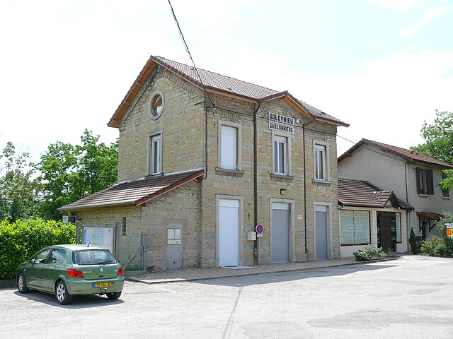

Soleymieu
- commune in Isère, France
Hiking in Soleymieu
Soleymieu, located in the Auvergne-Rhône-Alpes region of France, offers a delightful environment for hiking enthusiasts with its picturesque landscapes and varied terrains. Here are some key points to consider when planning a hike in Soleymieu:...
- Country:
- Postal Code: 38460
- Coordinates: 45° 42' 35" N, 5° 20' 59" E
- GPS tracks (wikiloc): [Link]
- Area: 13.36 sq km
- Population: 776

Vézeronce-Curtin
- commune in Isère, France
Hiking in Vézeronce-Curtin
Vézeronce-Curtin is a charming village located in the Auvergne-Rhône-Alpes region of France, known for its scenic landscapes and proximity to the beautiful natural areas surrounding it, including the Isère river valley. Here are some details about hiking in and around Vézeronce-Curtin:...
- Country:
- Postal Code: 38510
- Coordinates: 45° 39' 2" N, 5° 28' 14" E
- GPS tracks (wikiloc): [Link]
- AboveSeaLevel: 220 м m
- Area: 14.37 sq km
- Population: 2065
- Web site: [Link]


Saint-Chef
- commune in Isère, France
Hiking in Saint-Chef
Saint-Chef is a charming commune located in the Isère department of the Auvergne-Rhône-Alpes region in southeastern France. The area is known for its beautiful landscapes, rolling hills, and rich natural surroundings, making it an attractive destination for hikers of all levels....
- Country:
- Postal Code: 38890
- Coordinates: 45° 38' 2" N, 5° 21' 57" E
- GPS tracks (wikiloc): [Link]
- Area: 27.16 sq km
- Population: 3620
- Web site: [Link]