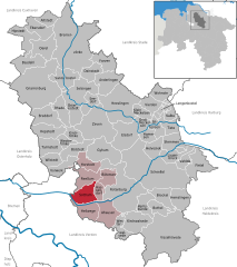
Sottrum (Samtgemeinde Sottrum)

- Samtgemeinde in Lower Saxony
 Hiking in Sottrum
Sottrum, located in Niedersachsen, Germany, offers a variety of hiking opportunities. The surrounding areas feature a mix of landscapes, including forests, meadows, and agricultural fields, providing a peaceful setting for hikers.
Key Features for Hiking in Sottrum:
-
Trails and Paths:
- There are several well-marked trails around Sottrum that cater to different skill levels. You can find flat, easy walks for beginners as well as more challenging routes for experienced hikers.
-
Nature Reserves:
- The nearby nature reserves offer rich biodiversity and beautiful scenery. Exploring these areas can provide not only a great hiking experience but also opportunities for bird watching and appreciating local flora.
-
Historical Sites:
- There are historical landmarks and traditional villages in the vicinity that can make your hike more interesting. Incorporating visits to these sites can enrich your understanding of the region’s culture.
-
Seasonal Hiking:
- Each season provides a different experience. Spring brings wildflowers, summer offers lush greenery, autumn showcases colorful foliage, and winter can transform the landscape into a serene wonderland.
-
Local Recommendations:
- Engaging with local hiking clubs or visiting a tourist information center can provide additional insights into the best trails and hidden gems in the area.
-
Safety and Preparation:
- As with any hiking experience, be sure to check the weather forecast, wear appropriate footwear, and carry enough water and snacks. It’s always a good idea to inform someone of your hiking plans.
Conclusion:
Sottrum offers a tranquil environment perfect for hikers looking to enjoy nature while also having the option to explore local culture. Whether you're looking for short nature walks or longer treks, you'll find a variety of paths to suit your interests.
- Country:

- Coordinates: 53° 7' 0" N, 9° 14' 0" E


- GPS tracks (wikiloc): [Link]
- Population: 14531
- Web site: http://www.sottrum.de/
- Wikipedia en: wiki(en)
- Wikipedia: wiki(de)
- Wikidata storage: Wikidata: Q486031
- Freebase ID: [/m/02w02wv]
- Freebase ID: [/m/02w02wv]
- Freebase ID: [/m/02w02wv]
- VIAF ID: Alt: [168150976]
- VIAF ID: Alt: [168150976]
- VIAF ID: Alt: [168150976]
- GND ID: Alt: [6037174-2]
- GND ID: Alt: [6037174-2]
- GND ID: Alt: [6037174-2]
- German regional key: 033575406
- German regional key: 033575406
- German regional key: 033575406
Includes regions:
Bötersen
- municipality of Germany
Hiking in Bötersen
Bötersen is a small municipality located in Lower Saxony, Germany. While it might not be widely recognized as a hiking hotspot, it offers a variety of scenic trails and natural beauty suited for outdoor enthusiasts who enjoy peaceful rural landscapes....
- Country:
- Postal Code: 27367
- Local Dialing Code: 04268
- Licence Plate Code: ROW
- Coordinates: 53° 8' 0" N, 9° 19' 0" E
- GPS tracks (wikiloc): [Link]
- AboveSeaLevel: 34 м m
- Area: 19.85 sq km
- Population: 1060
- Web site: [Link]
Ahausen
- municipality of Germany
Hiking in Ahausen
Ahausen, a quaint village located in Germany, offers some wonderful opportunities for hiking enthusiasts to explore its picturesque countryside and scenic trails. While it may not be as renowned as larger hiking areas, Ahausen’s charm lies in its tranquil landscapes and access to nearby natural attractions....
- Country:
- Postal Code: 27367
- Local Dialing Code: 04269
- Licence Plate Code: ROW
- Coordinates: 53° 3' 51" N, 9° 18' 53" E
- GPS tracks (wikiloc): [Link]
- AboveSeaLevel: 25 м m
- Area: 34.62 sq km
- Population: 1888
- Web site: [Link]
Horstedt
- municipality in Lower Saxony, Germany
Hiking in Horstedt
Horstedt is a charming area located in Lower Saxony, Germany, known for its picturesque landscapes, including woodlands, meadows, and small hills, making it a great spot for hiking enthusiasts. While it may not be as well known as some of Germany's larger national parks, Horstedt and the surrounding region offer lovely trails that are suitable for both beginners and experienced hikers....
- Country:
- Postal Code: 27367
- Local Dialing Code: 04288
- Licence Plate Code: ROW
- Coordinates: 53° 11' 0" N, 9° 14' 0" E
- GPS tracks (wikiloc): [Link]
- AboveSeaLevel: 33 м m
- Area: 22.49 sq km
- Population: 1302
- Web site: [Link]

Sottrum
- municipality of Germany
Hiking in Sottrum
Sottrum is a small town in Lower Saxony, Germany, not widely known for extensive hiking trails, but it offers a peaceful environment and some opportunities for nature walks and outdoor activities. Here are a few insights into hiking in and around Sottrum:...
- Country:
- Postal Code: 27367
- Local Dialing Code: 04264
- Licence Plate Code: ROW
- Coordinates: 53° 7' 0" N, 9° 13' 0" E
- GPS tracks (wikiloc): [Link]
- AboveSeaLevel: 20 м m
- Area: 28.58 sq km
- Population: 6397
- Web site: [Link]
Hellwege
- municipality of Germany
Hiking in Hellwege
Hellwege is a small municipality located in Lower Saxony, Germany. While it may not be a well-known hiking destination, the surrounding area offers a variety of landscapes, including scenic countryside, forests, and trails that can be enjoyable for hiking enthusiasts....
- Country:
- Postal Code: 27367
- Local Dialing Code: 04264
- Licence Plate Code: ROW
- Coordinates: 53° 4' 0" N, 9° 14' 0" E
- GPS tracks (wikiloc): [Link]
- AboveSeaLevel: 15 м m
- Area: 27.44 sq km
- Population: 1068
- Web site: [Link]
Hassendorf
- municipality of Germany
Hiking in Hassendorf
Hassendorf is a small area in Germany, but there are generally beautiful landscapes and natural parks to explore around such regions. If you’re looking to hike in and around Hassendorf, here are a few tips and information to consider:...
- Country:
- Postal Code: 27367
- Local Dialing Code: 04264
- Licence Plate Code: ROW
- Coordinates: 53° 6' 43" N, 9° 16' 37" E
- GPS tracks (wikiloc): [Link]
- AboveSeaLevel: 24 м m
- Area: 11.71 sq km
- Population: 1133
- Web site: [Link]
Reeßum
- municipality of Germany
Hiking in Reeßum
Reeßum, located in Lower Saxony, Germany, is a charming village surrounded by natural beauty, making it an appealing destination for hiking enthusiasts. While it may not be as well-known as some larger hiking hotspots, it offers scenic trails that provide a peaceful experience in the great outdoors....
- Country:
- Postal Code: 27367
- Local Dialing Code: 04264
- Licence Plate Code: ROW
- Coordinates: 53° 7' 0" N, 9° 13' 0" E
- GPS tracks (wikiloc): [Link]
- AboveSeaLevel: 20 м m
- Area: 28.47 sq km
- Population: 1712
- Web site: [Link]
Shares border with regions:


Kirchlinteln
- municipality of Germany
Hiking in Kirchlinteln
Kirchlinteln is a charming village located in Lower Saxony, Germany. The area offers a variety of hiking opportunities, primarily characterized by its picturesque landscapes, serene countryside, and lush forests....
- Country:
- Postal Code: 27308
- Local Dialing Code: 04238; 04237; 04236; 04231; 04230
- Licence Plate Code: VER
- Coordinates: 52° 57' 0" N, 9° 19' 0" E
- GPS tracks (wikiloc): [Link]
- AboveSeaLevel: 51 м m
- Area: 174.13 sq km
- Population: 9990
- Web site: [Link]