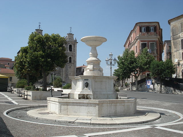
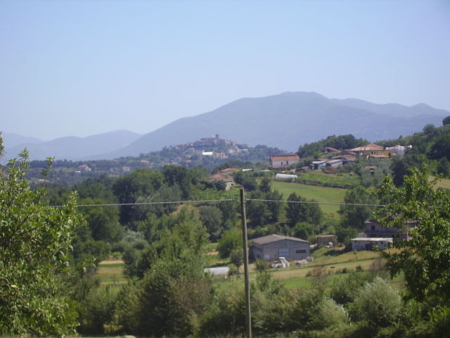
Strangolagalli (Strangolagalli)
.svg)
- Italian comune
 Hiking in Strangolagalli
Strangolagalli is a charming locality nestled in the province of Frosinone in the Lazio region of Italy. While it may not be as well-known as some of Italy's larger hiking destinations, it offers serene landscapes and opportunities to explore the natural beauty of the area.
Hiking Opportunities in Strangolagalli:
-
Scenic Trails: The area is surrounded by picturesque views of rolling hills, dense forests, and beautiful valleys. You can find various trails suited for different levels of hiking, from easy walks to more challenging hikes.
-
Nature and Wildlife: Hiking around Strangolagalli allows you to experience local flora and fauna. Keep an eye out for diverse plant species and possible sightings of wildlife native to the Apennine Mountains.
-
Historical Sites: The region is rich in history and culture. Some trails may lead you to ancient ruins, old farm buildings, or local churches that showcase the area's heritage and architecture.
-
Guided Tours: Local organizations may offer guided hikes, which can enhance your experience by providing insights into the culture, history, and nature of the region.
-
Seasonal Considerations: Depending on the time of year you visit, be prepared for varying weather. Spring and fall are typically ideal for hiking in terms of comfortable temperatures and beautiful views.
Tips for Hiking in Strangolagalli:
- Gear Up: Wear comfortable hiking shoes, and dress in layers to adjust to changing weather conditions.
- Safety First: Carry a first-aid kit, plenty of water, and snacks. Make sure someone knows your hiking plans.
- Leave No Trace: Be respectful of nature by following Leave No Trace principles—take all trash with you and stay on designated paths.
Whether you're looking for a leisurely stroll or a more vigorous hike, Strangolagalli can provide a peaceful escape into nature. Always check local maps and resources for the latest trail information and conditions before heading out. Happy hiking!
- Country:

- Postal Code: 03020
- Local Dialing Code: 0775
- Licence Plate Code: FR
- Coordinates: 41° 36' 0" N, 13° 29' 32" E


- GPS tracks (wikiloc): [Link]
- AboveSeaLevel: 232 м m
- Area: 10.57 sq km
- Population: 2414
- Web site: http://www.comune.strangolagalli.fr.it
- Wikipedia en: wiki(en)
- Wikipedia: wiki(it)
- Wikidata storage: Wikidata: Q117388
- Wikipedia Commons Category: [Link]
- Freebase ID: [/m/0gmxst]
- GeoNames ID: Alt: [6539767]
- VIAF ID: Alt: [242359917]
- OSM relation ID: [41393]
- UN/LOCODE: [ITSHR]
- ISTAT ID: 060075
- Italian cadastre code: I973
Shares border with regions:

Arce
- Italian comune
Hiking in Arce
Hiking in Arce, a charming town in the Lazio region of Italy, offers a blend of stunning natural landscapes, historical sites, and local culture. Situated in the province of Frosinone, Arce is surrounded by the picturesque Aurunci Mountains and is not far from the beautiful landscapes of the Ciociaria area....
- Country:
- Postal Code: 03032
- Local Dialing Code: 0776
- Licence Plate Code: FR
- Coordinates: 41° 35' 0" N, 13° 35' 0" E
- GPS tracks (wikiloc): [Link]
- AboveSeaLevel: 247 м m
- Area: 39.52 sq km
- Population: 5670
- Web site: [Link]


Boville Ernica
- Italian comune
Hiking in Boville Ernica
Boville Ernica is a charming town located in the province of Frosinone in the Lazio region of Italy. Nestled in the foothills of the Abruzzo Apennines, it offers not only historical sites but also a variety of outdoor activities, including hiking. Here are some highlights you might consider when hiking in and around Boville Ernica:...
- Country:
- Postal Code: 03022
- Local Dialing Code: 0775
- Licence Plate Code: FR
- Coordinates: 41° 38' 33" N, 13° 28' 26" E
- GPS tracks (wikiloc): [Link]
- AboveSeaLevel: 450 м m
- Area: 28.19 sq km
- Population: 8525
- Web site: [Link]
Ceprano
- Italian comune
Hiking in Ceprano
Ceprano is a picturesque town located in the province of Frosinone, Italy, known for its scenic landscapes and historical significance. It sits near the confluence of the Liri and Fibreno rivers, offering beautiful natural surroundings that are great for hiking enthusiasts....
- Country:
- Postal Code: 03024
- Local Dialing Code: 0775
- Licence Plate Code: FR
- Coordinates: 41° 33' 0" N, 13° 31' 0" E
- GPS tracks (wikiloc): [Link]
- AboveSeaLevel: 105 м m
- Area: 38.03 sq km
- Population: 8823
- Web site: [Link]


Monte San Giovanni Campano
- Italian comune
Hiking in Monte San Giovanni Campano
Monte San Giovanni Campano is a charming town located in the province of Frosinone, in the Lazio region of Italy. It is set in a picturesque landscape characterized by rolling hills, lush vegetation, and historical sites. Hiking in and around Monte San Giovanni Campano can provide an excellent opportunity for both nature lovers and those interested in exploring the historical backdrop of the region....
- Country:
- Postal Code: 03025
- Local Dialing Code: 0775
- Licence Plate Code: FR
- Coordinates: 41° 38' 0" N, 13° 31' 0" E
- GPS tracks (wikiloc): [Link]
- AboveSeaLevel: 420 м m
- Area: 48.71 sq km
- Population: 12706
- Web site: [Link]

Ripi
- Italian comune
Hiking in Ripi
Ripi is a small town located in the province of Frosinone in the Lazio region of Italy. While it may not be as famous for hiking as some larger areas or national parks, there are opportunities for outdoor enthusiasts to explore the beautiful landscapes and trails in and around the region....
- Country:
- Postal Code: 03027
- Local Dialing Code: 0775
- Licence Plate Code: FR
- Coordinates: 41° 37' 0" N, 13° 26' 0" E
- GPS tracks (wikiloc): [Link]
- AboveSeaLevel: 300 м m
- Area: 31.61 sq km
- Population: 5249
- Web site: [Link]