Surselva District (Bezirk Surselva)

- district in Switzerland
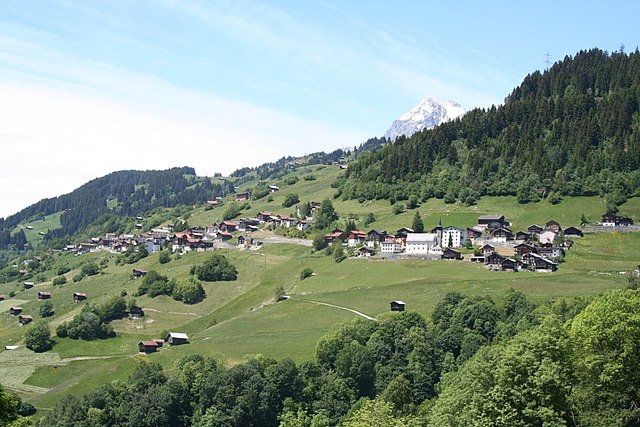
 Hiking in Surselva District
Surselva District, located in the canton of Graubünden in Switzerland, is an excellent destination for hiking enthusiasts, known for its stunning natural landscapes, diverse terrain, and rich cultural heritage. Here are some highlights and tips for hiking in the Surselva area:
Scenic Trails
-
Ruinaulta (Grand Canyon of Switzerland): This spectacular gorge carved by the Rhine River offers breathtaking views. There are several hiking paths along the rim, providing stunning vistas of the river and unique rock formations.
-
Senda Sursilvana: This long-distance hiking trail stretches across the Surselva region, linking various villages and offering a mix of pastoral landscapes, forests, and alpine scenery. It's a great way to experience the culture and traditions of the area.
-
Hiking Around Brigels: The trails around the charming village of Brigels offer routes suitable for both beginners and experienced hikers, with options ranging from easy walks to more challenging hikes with panoramic views.
-
Tavanasa to Talvue: This is a more adventurous route that takes you through diverse terrains, allowing you to explore the varied flora and fauna of the region. The views of the surrounding mountains are stunning.
Flora and Fauna
Surselva is home to diverse wildlife and plant species. As you hike, keep an eye out for local fauna like chamois and ibex, as well as a variety of bird species. The region's flora includes beautiful alpine flowers, especially in the summer months.
Cultural Insights
The Surselva region is rich in history and culture. Along your hikes, you may encounter traditional Swiss villages, historic churches, and ancient farmsteads. The Romansh language, a unique cultural element of the region, is still spoken by many residents.
Hiking Seasons
- Summer (June to September): Ideal for hiking, with warmer temperatures and fully accessible trails.
- Autumn (October): Offers beautiful fall colors, but be prepared for cooler weather and potentially less stable trail conditions.
- Winter: Some trails may be accessible for snowshoeing or winter hiking, but it’s important to check conditions and prepare for winter weather.
Preparation Tips
- Trail Maps: Get updated trail maps and information from local tourist offices or online resources to ensure you are following well-marked paths.
- Gear: Wear good hiking boots and appropriate clothing for changing weather conditions. Also, carry sufficient water, snacks, and possibly trekking poles.
- Safety: Always let someone know your hiking plans and expected return time, especially if you’re hiking in remote areas.
Accessibility
The Surselva region is accessible by public transportation, and many starting points for hikes are reachable via buses or trains. Familiarize yourself with the local transport options to make the most of your hiking experience.
With its beautiful landscapes and rich cultural tapestry, hiking in Surselva offers an unforgettable experience for all levels of hikers. Enjoy your adventures!
- Country:

- Licence Plate Code: GR
- Coordinates: 46° 46' 0" N, 9° 12' 0" E


- GPS tracks (wikiloc): [Link]
- AboveSeaLevel: 2379 м m
- Area: 1373.54 sq km
- Wikipedia en: wiki(en)
- Wikipedia: wiki(de)
- Wikidata storage: Wikidata: Q664727
- Wikipedia Commons Category: [Link]
- Freebase ID: [/m/093ffh]
- GeoNames ID: Alt: [7284999]
- HDS ID: [8084]
Includes regions:

Safien Subdistrict
- subdistrict in the canton of Graubünden, Switzerland
Hiking in Safien Subdistrict
Kreis Safien, located in the canton of Graubünden in Switzerland, is a fantastic destination for hiking enthusiasts. The region offers stunning landscapes, including high alpine terrain, lush valleys, and a variety of trails suitable for all skill levels. Here are some highlights and tips for hiking in Kreis Safien:...
- Country:

Lumnezia/Lugnez
- subdistrict in the canton of Graubünden, Switzerland
Hiking in Lumnezia/Lugnez
Kreis Lumnezia, located in the canton of Graubünden in Switzerland, is a remarkable area for hiking, known for its stunning alpine scenery, diverse landscapes, and charming villages. Here are some key points about hiking in this region:...
- Country:
Ruis
- subdistrict in the canton of Graubünden, Switzerland
Hiking in Ruis
Ruis, located in the scenic region of Graubünden in Switzerland, is a lesser-known but beautiful area for hiking enthusiasts. The region is characterized by stunning mountain views, lush valleys, and traditional Swiss architecture. Although Ruis itself may not be as famous as some other Swiss hiking destinations, it offers a perfect backdrop for anyone looking to explore the great outdoors....
- Country:
- Coordinates: 46° 46' 42" N, 9° 9' 3" E
- GPS tracks (wikiloc): [Link]

Disentis
- subdistrict in the canton of Graubünden, Switzerland
Hiking in Disentis
Kreis Disentis, located in the canton of Graubünden in Switzerland, is a splendid region for hiking enthusiasts, offering a variety of trails that cater to different skill levels and preferences. Here are some key highlights about hiking in this area:...
- Country:
- Capital: Disentis/Mustér

Ilanz
- subdistrict in the canton of Graubünden, Switzerland
Hiking in Ilanz
Ilanz, located in the canton of Graubünden in Switzerland, is a fantastic destination for hiking enthusiasts. Nestled in the Rhine Valley, Ilanz offers a diverse range of trails suitable for various skill levels, making it an excellent choice for both novice and experienced hikers....
- Country:
- Coordinates: 46° 45' 54" N, 9° 12' 0" E
- GPS tracks (wikiloc): [Link]