
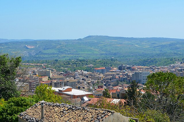
Syracuse (Siracusa)
.svg)
- Italian comune
 Hiking in Syracuse
Syracuse, located on the southeastern coast of Sicily, offers a unique blend of history, culture, and natural beauty that can make for a rewarding hiking experience. Here are some popular hiking routes and areas around Syracuse:
-
Plemmirio Marine Protected Area: Just a few kilometers from the city, this coastal park features stunning sea views, rugged cliffs, and diverse marine life. Trails range from easy walks along the coast to more challenging routes that lead you through the lush Mediterranean vegetation.
-
Cava Grande del Cassibile: This natural oasis, about 30 kilometers from Syracuse, features a breathtaking canyon with crystal-clear pools and waterfalls. The hike can be steep in areas but offers spectacular views and the opportunity to swim in natural pools.
-
Ortigia Island: While not a traditional hiking destination, strolling through the historical streets of Ortigia can be a delightful alternative. The island is dotted with ancient ruins, beautiful baroque architecture, and restaurants, making it a great place to explore on foot.
-
Mount Etna: Although it's a bit further away (roughly 100 kilometers from Syracuse), hiking on Mount Etna, Europe's highest and most active volcano, is a must for outdoor enthusiasts. Numerous trails vary in difficulty and offer different perspectives of the volcano's craters and breathtaking landscapes.
-
Vendicari Nature Reserve: Located to the south of Syracuse, this reserve features trails that meander through wetlands, sandy beaches, and ancient ruins. The area is also a haven for birdwatching, particularly during migration seasons.
Tips for Hiking in Syracuse:
- Weather Considerations: Sicilian summers can be hot, so it's advisable to hike early in the morning or later in the afternoon. The spring and fall offer more moderate temperatures.
- Proper Gear: Wear sturdy shoes, bring plenty of water, and don’t forget sunscreen and a hat, especially in the warmer months.
- Local Information: Familiarize yourself with the trail conditions and obtain maps or guides from local tourist information centers or hiking groups.
- Respect Nature: Follow the Leave No Trace principles, ensuring that you preserve the natural beauty of the area for future hikers.
Syracuse's mix of scenic views, historical significance, and diverse ecosystems makes it a wonderful place for hikers of all levels. Enjoy your adventures!
- Country:

- Postal Code: 96100
- Local Dialing Code: 0931
- Licence Plate Code: SR
- Coordinates: 37° 5' 0" N, 15° 17' 0" E


- GPS tracks (wikiloc): [Link]
- AboveSeaLevel: 17 м m
- Area: 207.78 sq km
- Population: 122086
- Web site: http://www.comune.siracusa.it
- Wikipedia en: wiki(en)
- Wikipedia: wiki(it)
- Wikidata storage: Wikidata: Q13670
- Wikipedia Commons Gallery: [Link]
- Wikipedia Commons Category: [Link]
- Wikipedia Commons Maps Category: [Link]
- Freebase ID: [/m/071bn]
- GeoNames ID: Alt: [6542286]
- BnF ID: [11956461n]
- VIAF ID: Alt: [131280663]
- OSM relation ID: [39169]
- GND ID: Alt: [4106466-5]
- archINFORM location ID: [1059]
- Library of Congress authority ID: Alt: [n81018794]
- PACTOLS thesaurus ID: [pcrtRvr0Lw5Wrt]
- MusicBrainz area ID: [58e2d7f4-2a28-4c51-97bd-6251c82c706f]
- WOEID: [20077073]
- Quora topic ID: [Syracuse-Italy]
- UN/LOCODE: [ITSIR]
- Encyclopædia Britannica Online ID: [place/Syracuse-Italy]
- Encyclopædia Universalis ID: [syracuse]
- EMLO location ID: [ed808d19-f9ae-413d-8336-a45456a02c1c]
- Facebook Places ID: [110692678959270]
- Great Russian Encyclopedia Online ID: [3665634]
- ISNI: Alt: [0000 0001 2158 6483]
- DMOZ ID: Alt: [Regional/Europe/Italy/Regions/Sicily/Localities/Syracuse/]
- Nomisma ID: [syracuse]
- ISTAT ID: 089017
- Italian cadastre code: I754
Shares border with regions:


Noto
- Italian comune
Hiking in Noto
Noto, located in the southeastern region of Sicily, Italy, is renowned for its stunning Baroque architecture, beautiful landscapes, and rich cultural heritage. When it comes to hiking, Noto and its surrounding areas offer a variety of trails that showcase the beauty of the Sicilian countryside, including coastal views, vineyards, and ancient ruins....
- Country:
- Postal Code: 96017
- Local Dialing Code: 0931
- Licence Plate Code: SR
- Coordinates: 36° 53' 0" N, 15° 5' 0" E
- GPS tracks (wikiloc): [Link]
- AboveSeaLevel: 152 м m
- Area: 554.99 sq km
- Population: 24028
- Web site: [Link]

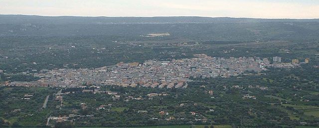
Palazzolo Acreide
- comune of Italy
Hiking in Palazzolo Acreide
Palazzolo Acreide, located in Sicily, Italy, is a wonderful destination for hiking enthusiasts. This charming town is known for its rich history, Baroque architecture, and stunning natural landscapes, set against the backdrop of the Iblei Mountains. Here are some key points to consider when planning a hiking adventure in this area:...
- Country:
- Postal Code: 96010
- Local Dialing Code: 0931
- Licence Plate Code: SR
- Coordinates: 37° 4' 0" N, 14° 54' 0" E
- GPS tracks (wikiloc): [Link]
- AboveSeaLevel: 670 м m
- Area: 87.54 sq km
- Population: 8665
- Web site: [Link]

Solarino
- Italian comune
Hiking in Solarino
Solarino, located in Sicily, Italy, is a charming town surrounded by beautiful landscapes and offers various hiking opportunities. This area is characterized by its rich nature, historical sites, and stunning views, making it a great destination for outdoor enthusiasts....
- Country:
- Postal Code: 96010
- Local Dialing Code: 0931
- Licence Plate Code: SR
- Coordinates: 37° 6' 0" N, 15° 7' 0" E
- GPS tracks (wikiloc): [Link]
- AboveSeaLevel: 165 м m
- Area: 13.02 sq km
- Population: 8130
- Web site: [Link]
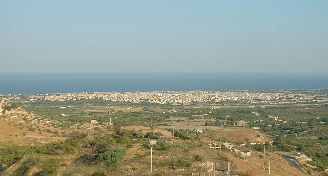

Avola
- Italian comune
Hiking in Avola
Avola is a charming town located in Sicily, Italy, known for its beautiful beaches, rich history, and exquisite natural surroundings. While Avola itself is primarily famous for its coastal attractions and the renowned Nero d'Avola wine, the surrounding areas offer a variety of hiking opportunities that cater to different skill levels and interests....
- Country:
- Postal Code: 96012
- Local Dialing Code: 0931
- Licence Plate Code: SR
- Coordinates: 36° 55' 0" N, 15° 8' 0" E
- GPS tracks (wikiloc): [Link]
- AboveSeaLevel: 40 м m
- Area: 74.59 sq km
- Population: 31408
- Web site: [Link]


Priolo Gargallo
- Italian comune
Hiking in Priolo Gargallo
Priolo Gargallo is a small town located in the province of Syracuse, Sicily, Italy. Nestled near the eastern coast, it offers unique landscapes and opportunities for hiking enthusiasts. While the town itself may not be as widely recognized for hiking as other regions in Sicily, it serves as a great base for exploring nearby natural attractions. Here are some key points about hiking in and around Priolo Gargallo:...
- Country:
- Postal Code: 96010
- Local Dialing Code: 0931
- Licence Plate Code: SR
- Coordinates: 37° 10' 0" N, 15° 11' 0" E
- GPS tracks (wikiloc): [Link]
- AboveSeaLevel: 30 м m
- Area: 56.92 sq km
- Population: 11883
- Web site: [Link]


Melilli
- Italian comune
Hiking in Melilli
Melilli is a charming town located in Sicily, Italy, surrounded by beautiful landscapes that offer various hiking opportunities. While Melilli itself may not be known as a major hiking destination, it serves as a great base for exploring the nearby natural areas and parks....
- Country:
- Postal Code: 96010
- Local Dialing Code: 0931
- Licence Plate Code: SR
- Coordinates: 37° 11' 0" N, 15° 7' 0" E
- GPS tracks (wikiloc): [Link]
- AboveSeaLevel: 310 м m
- Area: 136.42 sq km
- Population: 13519
- Web site: [Link]


Canicattini Bagni
- Italian comune
Hiking in Canicattini Bagni
Canicattini Bagni, a charming town in Sicily, Italy, is a great destination for hiking enthusiasts. Nestled in the Hyblaean Mountains, the area is characterized by stunning natural landscapes, rich flora and fauna, and a range of trails suitable for various skill levels. Here are some key points about hiking in Canicattini Bagni:...
- Country:
- Postal Code: 96010
- Local Dialing Code: 0931
- Licence Plate Code: SR
- Coordinates: 37° 2' 0" N, 15° 4' 0" E
- GPS tracks (wikiloc): [Link]
- AboveSeaLevel: 362 м m
- Area: 15.06 sq km
- Population: 7032
- Web site: [Link]


Floridia
- Italian comune
Hiking in Floridia
Hiking in Florida offers a unique experience thanks to the state's diverse ecosystems, ranging from coastal areas and wetlands to forests and springs. Here are some highlights if you’re considering hiking in Florida:...
- Country:
- Postal Code: 96014
- Local Dialing Code: 0931
- Licence Plate Code: SR
- Coordinates: 37° 5' 0" N, 15° 9' 0" E
- GPS tracks (wikiloc): [Link]
- AboveSeaLevel: 111 м m
- Area: 26.48 sq km
- Population: 22694
- Web site: [Link]