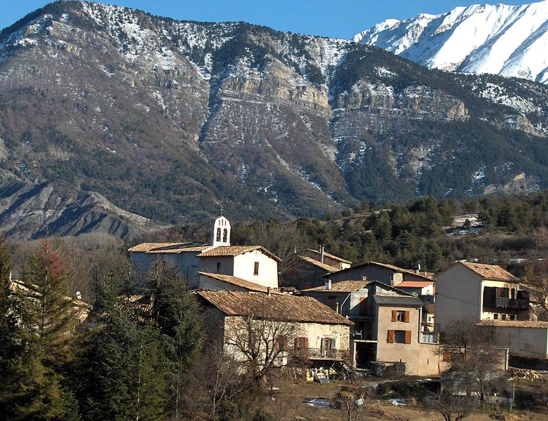
Tartonne (Tartonne)
- commune in Alpes-de-Haute-Provence, France
Tartonne is a charming village located in the Alpes-de-Haute-Provence region of southeastern France. It's an excellent starting point for various hiking adventures due to its stunning natural landscapes and proximity to the Mercantour National Park. Here are some key points to consider for hiking in Tartonne:
Hiking Trails
- Local Trails: Tartonne offers several local trails that vary in difficulty and length, suitable for both beginners and experienced hikers.
- Mercantour National Park: Just a short drive from Tartonne, this park is known for its breathtaking scenery, including rugged mountains, alpine lakes, and diverse flora and fauna. Popular hikes in the park include the hike to Lac Vert or the Vallée des Merveilles.
Scenic Highlights
- Mountain Views: Hiking around Tartonne often provides panoramic vistas of the surrounding Alps, particularly the impressive peaks of the Mercantour.
- Wildlife: Keep an eye out for local wildlife, which includes ibex, chamois, and a variety of bird species.
Practical Tips
- Best Time to Hike: The best hiking seasons are generally late spring through early autumn (May to October) when the weather is pleasant, and the trails are accessible.
- Preparation: Make sure to wear appropriate hiking shoes and bring necessary supplies including water, snacks, and a first aid kit.
- Navigation: Trails can vary in maintenance, so it's good to have a map or a GPS device. Local tourism offices can provide information on trail conditions.
Additional Considerations
- Accommodations and Amenities: Tartonne has a few options for lodging and dining, but you might want to plan ahead, especially during peak tourist seasons.
- Guided Tours: If you’re unfamiliar with the area or prefer a structured experience, consider hiring a local guide who can provide insights into the area's history and ecology.
Enjoy your hiking adventures in Tartonne, and remember to respect nature by sticking to the trails and practicing Leave No Trace principles!
- Country:

- Postal Code: 04330
- Coordinates: 44° 4' 12" N, 6° 23' 17" E


- GPS tracks (wikiloc): [Link]
- Area: 44.88 sq km
- Population: 138
- Web site: http://tartonne.free.fr
- Wikipedia en: wiki(en)
- Wikipedia: wiki(fr)
- Wikidata storage: Wikidata: Q1016768
- Wikipedia Commons Category: [Link]
- Freebase ID: [/m/03m7xqg]
- Freebase ID: [/m/03m7xqg]
- GeoNames ID: Alt: [2973328]
- GeoNames ID: Alt: [2973328]
- SIREN number: [210402145]
- SIREN number: [210402145]
- INSEE municipality code: 04214
- INSEE municipality code: 04214
Shares border with regions:

Lambruisse
- commune in Alpes-de-Haute-Provence, France
Lambruisse, often referred to in relation to its breathtaking natural landscapes and diverse hiking trails, is located in the French Alps, specifically in the Savoie region of France. This area is known for its stunning views, alpine meadows, and rich biodiversity. Here’s what you need to know about hiking in Lambruisse:...
- Country:

- Postal Code: 04170
- Coordinates: 44° 2' 53" N, 6° 26' 33" E


- GPS tracks (wikiloc): [Link]
- Area: 21.78 sq km
- Population: 98
- Web site: [Link]

Digne-les-Bains
- commune in Alpes-de-Haute-Provence, France
Digne-les-Bains, located in the Alpes-de-Haute-Provence region in southeastern France, is a beautiful area known for its stunning landscapes, rich history, and warm climate. The region offers a variety of hiking opportunities suitable for all levels, from easy strolls to challenging mountain trails....
- Country:

- Postal Code: 04000
- Coordinates: 44° 5' 33" N, 6° 14' 8" E


- GPS tracks (wikiloc): [Link]
- Area: 117.07 sq km
- Population: 16246
- Web site: [Link]

Draix
- commune in Alpes-de-Haute-Provence, France
Draix, a charming village in the Alpes-de-Haute-Provence region of France, offers a variety of hiking opportunities set against stunning natural backdrops. The area's mountainous terrain and lush surroundings make it an attractive destination for both novice and experienced hikers....
- Country:

- Postal Code: 04420
- Coordinates: 44° 8' 4" N, 6° 20' 35" E


- GPS tracks (wikiloc): [Link]
- Area: 23.04 sq km
- Population: 113

Thorame-Basse
- commune in Alpes-de-Haute-Provence, France
Thorame-Basse is a charming village located in the Alpes-de-Haute-Provence region of France. Nestled in the foothills of the Alps, it offers a variety of hiking opportunities that cater to different skill levels....
- Country:

- Postal Code: 04170
- Coordinates: 44° 5' 29" N, 6° 30' 4" E


- GPS tracks (wikiloc): [Link]
- Area: 97.72 sq km
- Population: 221
- Web site: [Link]

Archail
- commune in Alpes-de-Haute-Provence, France
Archail is not a widely recognized hiking destination, so information about it might be limited or could refer to a lesser-known area or a specific locality. It’s possible you may be referring to a region in France, India, or another country with a similar-sounding name....
- Country:

- Postal Code: 04420
- Coordinates: 44° 7' 17" N, 6° 20' 3" E


- GPS tracks (wikiloc): [Link]
- Area: 12.99 sq km
- Population: 16

Clumanc
- commune in Alpes-de-Haute-Provence, France
Clumanc, a picturesque village located in the Alpes-de-Haute-Provence department in southeastern France, is surrounded by stunning natural landscapes that offer various hiking opportunities. Hiking in this region provides a chance to enjoy scenic views, diverse flora and fauna, and the serenity of the French countryside....
- Country:

- Postal Code: 04330
- Coordinates: 44° 1' 25" N, 6° 22' 59" E


- GPS tracks (wikiloc): [Link]
- Area: 53.68 sq km
- Population: 204
