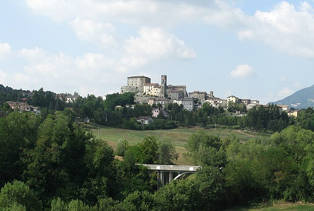
Tavoleto (Tavoleto)
.svg)
- Italian comune
 Hiking in Tavoleto
Tavoleto is a picturesque village located in the Marche region of Italy, surrounded by beautiful landscapes ideal for hiking. The area is characterized by rolling hills, lush forests, and stunning views of the surrounding countryside, making it a great destination for outdoor enthusiasts.
Hiking Trails:
-
Monte San Bartolo Regional Park: Just a short drive from Tavoleto, this park offers numerous trails with varying difficulty levels. You'll find paths that lead to panoramic viewpoints overlooking the Adriatic Sea and the Monte San Bartolo hills.
-
Sentiero degli Ulivi: This trail, known as the Olive Trail, takes hikers through olive groves and charming countryside. It’s a lovely way to experience the local flora and fauna while enjoying the serene atmosphere of the area.
-
Gola del Furlo: A bit further afield, this nature reserve is famous for its gorge and offers several hiking routes along the river and up into the hills. The stunning rock formations and diverse wildlife make it a must-visit.
-
Montefeltro Trails: The surrounding Montefeltro area offers a variety of trails suitable for different skill levels, with routes that pass through medieval villages, ancient castles, and scenic landscapes.
Best Time to Hike:
The best times to hike in Tavoleto are during the spring (April to June) and the fall (September to October) when the weather is mild, the scenery is vibrant, and there are fewer tourists. Summers can be hot, while winter hiking can be challenging due to snow in the higher elevations.
Tips for Hiking in Tavoleto:
- Equipment: Wear sturdy hiking shoes and dress in layers to accommodate changing weather conditions.
- Navigation: Download maps or use GPS, as some trails might not be well-marked.
- Local Guidance: Consider hiring a local guide or joining a hiking group to gain insights about the area's history and natural features.
- Respect Nature: Follow Leave No Trace principles to minimize your impact on the environment.
Conclusion:
Tavoleto offers a fantastic hiking experience with its combination of beautiful landscapes, charming villages, and rich history. Whether you’re an experienced hiker or a beginner, you’ll find trails that cater to your interests and abilities. Happy hiking!
- Country:

- Postal Code: 61020
- Local Dialing Code: 0722
- Licence Plate Code: PU
- Coordinates: 43° 50' 45" N, 12° 35' 33" E


- GPS tracks (wikiloc): [Link]
- AboveSeaLevel: 426 м m
- Area: 12.41 sq km
- Population: 871
- Web site: http://www.comune.tavoleto.pu.it
- Wikipedia en: wiki(en)
- Wikipedia: wiki(it)
- Wikidata storage: Wikidata: Q207654
- Wikipedia Commons Category: [Link]
- Freebase ID: [/m/0gl5bc]
- GeoNames ID: Alt: [6541054]
- VIAF ID: Alt: [139758780]
- OSM relation ID: [42674]
- ISTAT ID: 041064
- Italian cadastre code: L078
Shares border with regions:


Mondaino
- Italian comune
Hiking in Mondaino
Mondaino, a charming village in the Emilia-Romagna region of Italy, offers a variety of hiking opportunities amidst stunning landscapes. Nestled in the hills of the Marche region, Mondaino is known for its picturesque views, historical sites, and rich natural surroundings. Here are some highlights for hiking in and around Mondaino:...
- Country:
- Postal Code: 47836
- Local Dialing Code: 0541
- Licence Plate Code: RN
- Coordinates: 43° 51' 21" N, 12° 40' 17" E
- GPS tracks (wikiloc): [Link]
- AboveSeaLevel: 420 м m
- Area: 19.84 sq km
- Population: 1390
- Web site: [Link]


Montefiore Conca
- Italian comune
Hiking in Montefiore Conca
Montefiore Conca is a charming hilltop village located in the Emilia-Romagna region of Italy, known for its stunning landscapes and historical significance. The surrounding area offers several hiking opportunities that cater to various skill levels, with trails that provide breathtaking views of the countryside, rolling hills, and medieval architecture....
- Country:
- Postal Code: 47834
- Local Dialing Code: 0541
- Licence Plate Code: RN
- Coordinates: 43° 53' 0" N, 12° 37' 0" E
- GPS tracks (wikiloc): [Link]
- AboveSeaLevel: 385 м m
- Area: 22.32 sq km
- Population: 2278
- Web site: [Link]


Saludecio
- Italian comune
Hiking in Saludecio
Saludecio, a charming village in the Emilia-Romagna region of Italy, offers beautiful hiking opportunities that showcase the stunning landscapes of the area. Located in the hills overlooking the Adriatic Sea, hikers can enjoy a variety of trails that cater to different skill levels, ranging from leisurely strolls to more challenging routes....
- Country:
- Postal Code: 47835
- Local Dialing Code: 0541
- Licence Plate Code: RN
- Coordinates: 43° 52' 22" N, 12° 40' 7" E
- GPS tracks (wikiloc): [Link]
- AboveSeaLevel: 350 м m
- Area: 34.27 sq km
- Population: 3063
- Web site: [Link]


Mercatino Conca
- Italian comune
Hiking in Mercatino Conca
Mercatino Conca is a charming little town located in the Marche region of Italy, surrounded by beautiful landscapes that are perfect for hiking. The area is characterized by its rolling hills, lush forests, and stunning panoramic views....
- Country:
- Postal Code: 61013
- Local Dialing Code: 0541
- Licence Plate Code: PU
- Coordinates: 43° 52' 14" N, 12° 29' 30" E
- GPS tracks (wikiloc): [Link]
- AboveSeaLevel: 275 м m
- Area: 13.95 sq km
- Population: 1038
- Web site: [Link]

Monte Cerignone
- Italian comune
Hiking in Monte Cerignone
Monte Cerignone is a beautiful area located in the Marche region of Italy, known for its stunning landscapes, rich history, and charming villages. The mountain itself is part of the larger Apennine range and offers various hiking opportunities suitable for different skill levels. Here’s what you can expect when hiking in Monte Cerignone:...
- Country:
- Postal Code: 61010
- Local Dialing Code: 0541
- Licence Plate Code: PU
- Coordinates: 43° 50' 28" N, 12° 24' 46" E
- GPS tracks (wikiloc): [Link]
- AboveSeaLevel: 528 м m
- Area: 18.24 sq km
- Population: 656
- Web site: [Link]
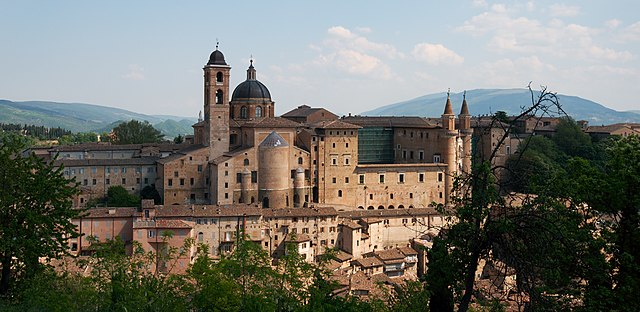

Urbino
- city in the Marche region of Italy
Hiking in Urbino
Urbino, a historic city in the Marche region of Italy, is surrounded by beautiful landscapes and offers various hiking opportunities for outdoor enthusiasts. Here are some key points about hiking in and around Urbino:...
- Country:
- Postal Code: 61029
- Local Dialing Code: 0722
- Licence Plate Code: PU
- Coordinates: 43° 43' 31" N, 12° 38' 14" E
- GPS tracks (wikiloc): [Link]
- AboveSeaLevel: 451 м m
- Area: 226.5 sq km
- Population: 14558
- Web site: [Link]