Tegel (Tegel)

- locality of Berlin
 Hiking in Tegel
Tegel, located in the northern part of Berlin, Germany, is known for its beautiful natural surroundings, including lakes and forests, making it a great area for hiking and outdoor activities. Here are some highlights and tips for hiking in the Tegel area:
1.
- Description: This large forest area offers a variety of trails through picturesque woodlands. It’s a great place to enjoy nature and spot local wildlife.
- Trails: There are well-marked trails of varying lengths, suitable for both casual walkers and more experienced hikers. The paths are generally easy to navigate.
2.
- Description: Tegeler See is a beautiful lake adjacent to the forest. The area around the lake has scenic walking paths, and it's possible to hike a loop around the water.
- Activities: In addition to hiking, you can engage in activities like swimming, boating, or picnicking by the lakeside.
3.
- Description: This smaller lake is located nearby and offers more relaxed hiking options. The surrounding area is quiet and ideal for a peaceful walk.
- Scenery: The views are particularly lovely in the spring and summer months when the flora is at its most vibrant.
4.
- Gear: Wear appropriate hiking shoes and bring plenty of water, especially in warmer months.
- Weather: Check the weather forecast before heading out, as conditions can change quickly.
- Maps and Navigation: It’s a good idea to have a map or a hiking app on your phone, as some trails may not be clearly marked.
- Stay on Trails: To protect the local ecosystem, try to stick to marked trails and avoid venturing off-path.
5.
- Tegel is easily accessible via public transport from various parts of Berlin, making it a convenient option for both locals and tourists.
6.
- Keep an eye out for various bird species and other wildlife, as the area is home to diverse fauna.
7.
- Beyond hiking, there are opportunities for cycling, jogging, and even horseback riding in some sections of the forest.
Hiking in Tegel provides a wonderful escape from the urban environment of Berlin, allowing you to immerse yourself in nature. Whether you're looking for a leisurely stroll or a more intense hike, there’s something for everyone. Enjoy your time outdoors!
- Country:

- Postal Code: 13509; 13507; 13505; 13503; 13405
- Coordinates: 52° 35' 0" N, 13° 17' 0" E


- GPS tracks (wikiloc): [Link]
- AboveSeaLevel: 36 м m
- Area: 33.7 sq km
- Population: 35474
- Wikipedia en: wiki(en)
- Wikipedia: wiki(de)
- Wikidata storage: Wikidata: Q700055
- Wikipedia Commons Gallery: [Link]
- Wikipedia Commons Category: [Link]
- Wikipedia Commons Maps Category: [Link]
- Freebase ID: [/m/03j3qc]
- GeoNames ID: Alt: [2823708]
- VIAF ID: Alt: [244995862]
- OSM relation ID: [55747]
- GND ID: Alt: [4080374-0]
- archINFORM location ID: [43220]
Shares border with regions:


Heiligensee
- locality of Berlin
Hiking in Heiligensee
Heiligensee, located in the northeastern part of Berlin, Germany, is a peaceful and charming area that offers various outdoor activities, including hiking. Here are some key aspects to consider when hiking in Heiligensee:...
- Country:
- Postal Code: 13505; 13503
- Coordinates: 52° 37' 0" N, 13° 14' 0" E
- GPS tracks (wikiloc): [Link]
- AboveSeaLevel: 39 м m
- Area: 10.7 sq km
- Population: 17834


Konradshöhe
- locality of Berlin
Hiking in Konradshöhe
Konradshöhe is a neighborhood located in the northern part of Berlin, Germany. While it may not be primarily known as a hiking destination, there are some beautiful areas and green spaces nearby that offer opportunities for walking and enjoying nature....
- Country:
- Postal Code: 13505
- Coordinates: 52° 35' 0" N, 13° 14' 0" E
- GPS tracks (wikiloc): [Link]
- AboveSeaLevel: 39 м m
- Area: 2.2 sq km
- Population: 6029


Wittenau
- locality of Berlin
Hiking in Wittenau
Wittenau is a district in the borough of Reinickendorf in Berlin, Germany. While Wittenau itself is primarily urban and residential, it offers some walking and hiking opportunities, especially in nearby parks and natural areas....
- Country:
- Postal Code: 13469; 13439; 13437; 13435
- Coordinates: 52° 35' 31" N, 13° 19' 35" E
- GPS tracks (wikiloc): [Link]
- AboveSeaLevel: 41 м m
- Area: 5.9 sq km
- Population: 25118


Frohnau
- locality of Berlin
Hiking in Frohnau
Frohnau is a district of the city of Annaberg-Buchholz in the Erzgebirge (Ore Mountains) region of Germany, known for its stunning natural landscapes and rich history. When hiking in Frohnau, you'll have the opportunity to explore beautiful trails, lush forests, and picturesque views....
- Country:
- Postal Code: 13465
- Coordinates: 52° 38' 0" N, 13° 18' 0" E
- GPS tracks (wikiloc): [Link]
- AboveSeaLevel: 55 м m
- Area: 7.8 sq km
- Population: 16782


Waidmannslust
- locality of Berlin
Hiking in Waidmannslust
Waidmannslust is a neighborhood located in the northeastern part of Berlin, Germany. While it is primarily a residential area and doesn’t have extensive hiking trails in the traditional sense, there are several nearby locations that offer green spaces and opportunities for walking and light hiking. Here are some options for exploring the area:...
- Country:
- Coordinates: 52° 36' 24" N, 13° 19' 15" E
- GPS tracks (wikiloc): [Link]
- AboveSeaLevel: 47 м m
- Area: 2.3 sq km

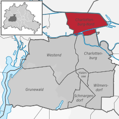
Charlottenburg-Nord
- locality of Berlin
Hiking in Charlottenburg-Nord
Charlottenburg-Nord, located in Berlin, Germany, is primarily an urban area; however, it does offer some opportunities for outdoor activities, including hiking. While it's not known for extensive wilderness trails, you can find some pleasant green spaces and parks where you can enjoy a walk or a leisurely hike....
- Country:
- Postal Code: 13627
- Coordinates: 52° 32' 20" N, 13° 17' 35" E
- GPS tracks (wikiloc): [Link]
- AboveSeaLevel: 28 м m
- Area: 6.20 sq km
- Population: 18856

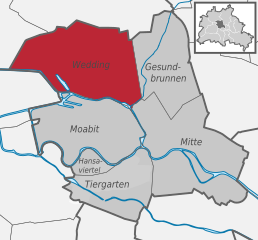
Wedding
- locality in the borough of Mitte, Berlin, Germany
Hiking in Wedding
Hiking in Wedding, a district in the borough of Mitte, Berlin, might not be the first thing that comes to mind when you think of hiking, as it is primarily an urban area. However, there are several parks and green spaces within and around Wedding where you can enjoy short hikes or leisurely walks....
- Country:
- Postal Code: 13407; 13359; 13357; 13353; 13351; 13349; 13347
- Coordinates: 52° 33' 0" N, 13° 22' 0" E
- GPS tracks (wikiloc): [Link]
- AboveSeaLevel: 41 м m
- Area: 9.23 sq km
- Population: 83612


Reinickendorf
- locality of the borough Reinickendorf of Berlin
Hiking in Reinickendorf
Reinickendorf is a district located in the northern part of Berlin, Germany. While it's primarily an urban area, it offers several opportunities for hiking and outdoor activities, particularly in its parks and natural reserves....
- Country:
- Postal Code: 13409; 13407; 13403
- Coordinates: 52° 34' 0" N, 13° 20' 0" E
- GPS tracks (wikiloc): [Link]
- AboveSeaLevel: 42 м m
- Area: 10.5 sq km
- Population: 80687