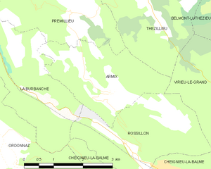
Thézillieu (Thézillieu)
- commune in Ain, France
 Hiking in Thézillieu
Thézillieu is a picturesque village located in the Ain department of France, nestled in the beautiful landscapes of the Rhône-Alpes region. Hiking in and around Thézillieu offers a wonderful opportunity to explore the natural beauty of the French countryside, with trails that cater to various skill levels. Here are some highlights and tips for hiking in this area:
Trails and Routes
- Local Trails: There are several marked trails that take you through the forests and hills surrounding Thézillieu. Look for local maps or information boards to guide your hiking adventure.
- Viamont Trail: This scenic route offers moderate hiking through beautiful landscapes and provides fantastic views of the surrounding valleys.
- Nearby Parks: Consider venturing slightly farther to explore trails in nearby regional parks, such as the Parc naturel régional du Haut-Jura, which features more extensive hiking opportunities.
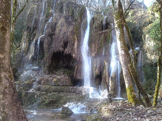
Scenic Views
- The terrain varies from gentle hills to more challenging slopes, giving hikers the chance to enjoy dramatic vistas of the Ain region and the Jura mountains.
- Be on the lookout for local wildlife, as the area is home to various bird species and small mammals.
Preparation
- Maps and Navigation: Always have a good map and a compass or a GPS device. Familiarize yourself with the trails and their difficulty levels before setting out.
- Gear: Wear sturdy hiking boots and comfortable clothing suitable for the weather. Bring plenty of water and snacks.
- Season: Spring and autumn are particularly stunning for hiking due to the colorful foliage and milder temperatures.
Safety
- Always check the weather forecast before heading out, as conditions can change rapidly in mountainous areas.
- Inform someone about your hiking plans, especially if you're venturing into less-traveled trails.
Local Culture
- After your hike, consider visiting local cafes or shops to sample regional cuisine or buy local products. Engaging with the community can enhance your experience.
Hiking in Thézillieu can be a rewarding experience, allowing you to connect with nature while exploring the charms of rural France. Be sure to enjoy the tranquility and beauty of this lovely region!
- Country:

- Postal Code: 01110
- Coordinates: 45° 53' 34" N, 5° 36' 3" E


- GPS tracks (wikiloc): [Link]
- Area: 26.25 sq km
- Population: 300
- Web site: http://www.thezillieu.fr
- Wikipedia en: wiki(en)
- Wikipedia: wiki(fr)
- Wikidata storage: Wikidata: Q462659
- Wikipedia Commons Category: [Link]
- Wikipedia Commons Maps Category: [Link]
- Freebase ID: [/m/081s93]
- Freebase ID: [/m/081s93]
- GeoNames ID: Alt: [6424714]
- GeoNames ID: Alt: [6424714]
- SIREN number: [210104170]
- SIREN number: [210104170]
- INSEE municipality code: 01417
- INSEE municipality code: 01417
Shares border with regions:

Armix
- commune in Ain, France
Hiking in Armix
It seems there may be a misunderstanding, as "Armix" is not widely recognized as a specific hiking destination or region in most hiking literature or databases. However, it's possible that you may be referring to a local area, park, or a lesser-known trail....
- Country:
- Postal Code: 01510
- Coordinates: 45° 50' 57" N, 5° 35' 8" E
- GPS tracks (wikiloc): [Link]
- Area: 6.82 sq km
- Population: 24

Belmont-Luthézieu
- commune in Ain, France
Hiking in Belmont-Luthézieu
Belmont-Luthézieu is a charming area located in the Auvergne-Rhône-Alpes region of France, known for its beautiful landscapes and outdoor activities, including hiking. The region features diverse terrain, including rolling hills, forests, and scenic viewpoints, making it a great spot for both novice and experienced hikers....
- Country:
- Postal Code: 01260
- Coordinates: 45° 52' 50" N, 5° 39' 40" E
- GPS tracks (wikiloc): [Link]
- Area: 19.77 sq km
- Population: 572
- Web site: [Link]

Cormaranche-en-Bugey
- commune in Ain, France
Hiking in Cormaranche-en-Bugey
Cormaranche-en-Bugey is a charming village located in the Bugey region of the Auvergne-Rhône-Alpes in France. It's known for its beautiful landscapes, lush greenery, and a variety of outdoor activities, making it a great destination for hiking enthusiasts....
- Country:
- Postal Code: 01110
- Coordinates: 45° 57' 11" N, 5° 36' 40" E
- GPS tracks (wikiloc): [Link]
- Area: 18.92 sq km
- Population: 803
- Web site: [Link]
Virieu-le-Grand
- commune in Ain, France
Hiking in Virieu-le-Grand
Virieu-le-Grand is a charming village located in the Auvergne-Rhône-Alpes region of France, nestled between beautiful natural landscapes, making it a great destination for hiking enthusiasts. The area offers several hiking trails that vary in difficulty, catering to both beginners and experienced hikers....
- Country:
- Postal Code: 01510
- Coordinates: 45° 50' 57" N, 5° 39' 6" E
- GPS tracks (wikiloc): [Link]
- Area: 12.55 sq km
- Population: 1067
- Web site: [Link]

Hauteville-Lompnes
- commune in Ain, France
Hiking in Hauteville-Lompnes
Hauteville-Lompnes, located in the Ain department of the Auvergne-Rhône-Alpes region in France, is a stunning destination for hiking enthusiasts. Nestled in the foothills of the Alps, it offers a variety of trails ranging from easy walks to more challenging hikes, making it suitable for hikers of all experience levels....
- Country:
- Postal Code: 01110
- Coordinates: 45° 58' 44" N, 5° 35' 58" E
- GPS tracks (wikiloc): [Link]
- Area: 50.34 sq km
- Population: 3739
- Web site: [Link]

Sutrieu
- commune in Ain, France
Hiking in Sutrieu
Sutrieu, located in the Ain department of the Auvergne-Rhône-Alpes region in France, is known for its beautiful natural landscapes and hiking opportunities. The area is characterized by rolling hills, forests, and panoramic views, making it a great destination for outdoor enthusiasts....
- Country:
- Postal Code: 01260
- Coordinates: 45° 57' 5" N, 5° 39' 32" E
- GPS tracks (wikiloc): [Link]
- Area: 19.05 sq km
- Population: 211

Hostiaz
- commune in Ain, France
Hiking in Hostiaz
Hostiaz is a charming village located in the Savoie region of France, known for its beautiful mountain landscapes and tranquil surroundings, making it a great destination for hiking enthusiasts. Here are some aspects of hiking in and around Hostiaz:...
- Country:
- Postal Code: 01110
- Coordinates: 45° 54' 6" N, 5° 32' 4" E
- GPS tracks (wikiloc): [Link]
- Area: 10.6 sq km
- Population: 87


Prémillieu
- commune in Ain, France
Hiking in Prémillieu
Prémillieu is a small commune situated in the Department of Isère in the Auvergne-Rhône-Alpes region of southeastern France. While it might not be as well-known as some larger hiking destinations in the region, it offers beautiful landscapes and a peaceful environment, making it suitable for hiking enthusiasts looking for less crowded trails....
- Country:
- Postal Code: 01110
- Coordinates: 45° 52' 27" N, 5° 34' 17" E
- GPS tracks (wikiloc): [Link]
- Area: 8.51 sq km
- Population: 47