Thiville (Thiville)

- commune in Eure-et-Loir, France
- Country:

- Postal Code: 28200
- Coordinates: 48° 1' 31" N, 1° 22' 30" E


- GPS tracks (wikiloc): [Link]
- Area: 27.8 sq km
- Population: 347
- Wikipedia en: wiki(en)
- Wikipedia: wiki(fr)
- Wikidata storage: Wikidata: Q1137890
- Wikipedia Commons Category: [Link]
- Freebase ID: [/m/03nrn12]
- GeoNames ID: Alt: [6430911]
- SIREN number: [212803894]
- BnF ID: [15254319f]
- INSEE municipality code: 28389
Shares border with regions:


La Chapelle-du-Noyer
- commune in Eure-et-Loir, France
- Country:
- Postal Code: 28200
- Coordinates: 48° 3' 27" N, 1° 18' 47" E
- GPS tracks (wikiloc): [Link]
- Area: 13.31 sq km
- Population: 1060


Autheuil
- former commune in Eure-et-Loir, France
- Country:
- Postal Code: 28220
- Coordinates: 48° 0' 28" N, 1° 17' 23" E
- GPS tracks (wikiloc): [Link]
- Area: 16.07 sq km
- Population: 192


Lutz-en-Dunois
- former commune in Eure-et-Loir, France
- Country:
- Postal Code: 28200
- Coordinates: 48° 3' 33" N, 1° 24' 51" E
- GPS tracks (wikiloc): [Link]
- Area: 27.48 sq km
- Population: 415
- Web site: [Link]
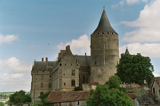
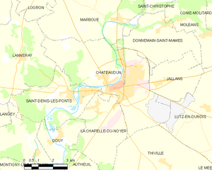
Châteaudun
- commune in Eure-et-Loir, France
- Country:
- Postal Code: 28200
- Coordinates: 48° 4' 15" N, 1° 20' 16" E
- GPS tracks (wikiloc): [Link]
- AboveSeaLevel: 140 м m
- Area: 28.48 sq km
- Population: 12980
- Web site: [Link]


Ozoir-le-Breuil
- former commune in Eure-et-Loir, France
- Country:
- Postal Code: 28200
- Coordinates: 48° 0' 49" N, 1° 28' 46" E
- GPS tracks (wikiloc): [Link]
- Area: 22.3 sq km
- Population: 447


Le Mée
- former commune in Eure-et-Loir, France
- Country:
- Postal Code: 28220
- Coordinates: 47° 59' 8" N, 1° 24' 57" E
- GPS tracks (wikiloc): [Link]
- Area: 19.11 sq km
- Population: 267


La Ferté-Villeneuil
- former commune in Eure-et-Loir, France
- Country:
- Postal Code: 28220
- Coordinates: 47° 58' 57" N, 1° 20' 40" E
- GPS tracks (wikiloc): [Link]
- Area: 8.41 sq km
- Population: 370