Tillmitsch (Tillmitsch)
- municipality in Austria
 Hiking in Tillmitsch
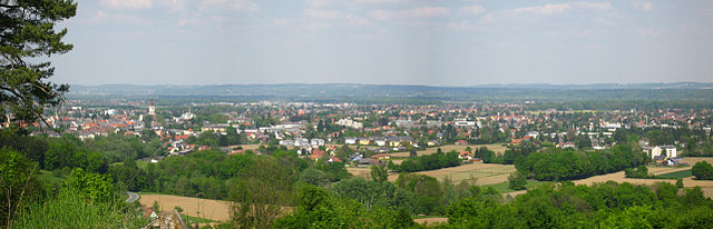
Tillmitsch is a charming village located in Styria, Austria, and offers a variety of hiking opportunities for enthusiasts of all skill levels. The region is characterized by picturesque landscapes, rolling hills, vineyards, and scenic views of the surrounding countryside.
Key Hiking Trails and Features:
-
Local Trails: Tillmitsch has a network of well-marked hiking trails. Many of these trails wind through the surrounding vineyards and forests, providing a lovely mix of nature and local culture.
-
Scenic Views: The trails often lead to vantage points where hikers can enjoy stunning views of the Styrian hills and the Mur Valley, particularly beautiful during autumn when the foliage changes color.
-
Easy to Moderate Routes: Many trails in the area are relatively easy to moderate, making them suitable for families, casual hikers, and those looking for a leisurely day out in nature.
-
Flora and Fauna: Hikers have the chance to experience the region's diverse flora and fauna. If you're lucky, you might spot local wildlife, including birds and various small mammals.
-
Cultural Highlights: Along the trails, you may encounter traditional Styrian architecture, charming farms, and local wineries, providing an opportunity to enjoy the region's renowned wine culture.
Tips for Hiking in Tillmitsch:
- Preparation: Always check the weather before heading out, and dress in layers to accommodate temperature changes.
- Bring Water and Snacks: While some trails might lead to amenities, it's best to carry enough water and snacks for your hike.
- Local Maps: Consider obtaining a local map or using a hiking app to navigate the trails effectively.
- Respect Nature: Follow the Leave No Trace principles, stay on marked trails, and respect the local wildlife and habitats.
Accessibility:
Tillmitsch is accessible from larger cities in the region, making it a great destination for a day trip. The area is also well connected by public transportation, so hikers can easily reach starting points for various trails.
Overall, hiking in Tillmitsch presents a wonderful opportunity to explore the beauty of Styria while enjoying the tranquil atmosphere of the Austrian countryside.
- Country:

- Local Dialing Code: 03452
- Licence Plate Code: LB
- Coordinates: 46° 48' 41" N, 15° 30' 48" E


- GPS tracks (wikiloc): [Link]
- AboveSeaLevel: 276 м m
- Area: 14.99 sq km
- Population: 3284
- Web site: http://www.tillmitsch.at/
- Wikipedia en: wiki(en)
- Wikipedia: wiki(de)
- Wikidata storage: Wikidata: Q876246
- Wikipedia Commons Category: [Link]
- Freebase ID: [/m/03gwd65]
- GeoNames ID: Alt: [2763597]
- VIAF ID: Alt: [172631294]
- GND ID: Alt: [16165360-1]
- archINFORM location ID: [10026]
- Austrian municipality key: [61043]
Shares border with regions:


Gralla
- municipality in Austria
Hiking in Gralla
Gralla is a small village located in Slovenia, within the municipality of Slovenska Bistrica. The area surrounding Gralla offers a charming landscape suited for hiking, especially for those who enjoy peaceful countryside views and exploring the natural beauty of the region....
- Country:
- Postal Code: 8431
- Local Dialing Code: 03452
- Licence Plate Code: LB
- Coordinates: 46° 49' 18" N, 15° 33' 49" E
- GPS tracks (wikiloc): [Link]
- AboveSeaLevel: 278 м m
- Area: 12.14 sq km
- Population: 2390
- Web site: [Link]
Leibnitz
- city in Styria
Hiking in Leibnitz
Leibnitz, located in Styria, Austria, is a delightful region for hiking enthusiasts. The area is characterized by its rolling hills, vineyards, and picturesque landscapes, offering a variety of trails suitable for different skill levels. Here are some highlights and tips for hiking in Leibnitz:...
- Country:
- Postal Code: 8430, 8435, 8451, 8462
- Local Dialing Code: 03452
- Coordinates: 46° 46' 59" N, 15° 32' 42" E
- GPS tracks (wikiloc): [Link]
- AboveSeaLevel: 275 м m
- Area: 23.53 sq km
- Population: 12176
- Web site: [Link]
Lebring-Sankt Margarethen
- municipality in Austria
Hiking in Lebring-Sankt Margarethen
Lebring-Sankt Margarethen is a picturesque region in the Styria province of Austria, known for its beautiful landscapes and outdoor recreational opportunities. When it comes to hiking, this area offers a mix of scenic routes suitable for various skill levels, all set against the backdrop of rolling hills and lush greenery....
- Country:
- Postal Code: 8403
- Local Dialing Code: 03182
- Licence Plate Code: LB
- Coordinates: 46° 51' 49" N, 15° 31' 40" E
- GPS tracks (wikiloc): [Link]
- AboveSeaLevel: 286 м m
- Area: 7.59 sq km
- Population: 2168
- Web site: [Link]
Sankt Nikolai im Sausal
- municipality in Austria
Hiking in Sankt Nikolai im Sausal
Sankt Nikolai im Sausal is a picturesque village located in the Styrian region of Austria, surrounded by beautiful hills and natural landscapes. This area offers a variety of hiking opportunities, making it an appealing destination for both beginner and experienced hikers....
- Country:
- Postal Code: 8505
- Local Dialing Code: 03185
- Licence Plate Code: LB
- Coordinates: 46° 49' 16" N, 15° 26' 57" E
- GPS tracks (wikiloc): [Link]
- AboveSeaLevel: 342 м m
- Area: 26.18 sq km
- Population: 2257
- Web site: [Link]

Lang
- municipality in Austria
Hiking in Lang
Lang, a picturesque area in Styria, Austria, offers a variety of hiking opportunities, making it a remarkable destination for outdoor enthusiasts. The region features stunning landscapes, rolling hills, lush forests, and scenic views of the surrounding mountains....
- Country:
- Postal Code: 8403
- Local Dialing Code: 03182
- Licence Plate Code: LB
- Coordinates: 46° 50' 14" N, 15° 30' 10" E
- GPS tracks (wikiloc): [Link]
- AboveSeaLevel: 286 м m
- Area: 15.66 sq km
- Population: 1325
- Web site: [Link]


Heimschuh
- municipality in Austria
Hiking in Heimschuh
Heimschuh, located in Austria, offers a charming environment for hiking enthusiasts. This small town is situated in the scenic region of Styria, known for its lush landscapes, rolling hills, and vineyards. When planning a hiking trip in Heimschuh, consider the following:...
- Country:
- Postal Code: 8451
- Local Dialing Code: 03452
- Licence Plate Code: LB
- Coordinates: 46° 45' 12" N, 15° 29' 18" E
- GPS tracks (wikiloc): [Link]
- AboveSeaLevel: 280 м m
- Area: 18.52 sq km
- Population: 1968
- Web site: [Link]

Kitzeck im Sausal
- municipality in Austria
Hiking in Kitzeck im Sausal
Kitzeck im Sausal is a charming village located in Styria, Austria, and is renowned for its picturesque landscapes and wine-growing region. It offers a variety of hiking opportunities suitable for different skill levels. Here are some details that might help you enjoy your hiking experience in Kitzeck im Sausal:...
- Country:
- Postal Code: 8441, 8442, 8451
- Local Dialing Code: 03456
- Licence Plate Code: LB
- Coordinates: 46° 46' 52" N, 15° 27' 12" E
- GPS tracks (wikiloc): [Link]
- AboveSeaLevel: 564 м m
- Area: 16.29 sq km
- Population: 1228
- Web site: [Link]