Leibnitz District (Bezirk Leibnitz)

- district of Austria
 Hiking in Leibnitz District
Leibnitz District, located in southern Austria's Styria region, is a fantastic destination for hiking enthusiasts. The region is known for its picturesque landscapes, rolling hills, vineyards, and charming villages. Here are some key points about hiking in the Leibnitz District:
Scenic Trails
-
Südsteirische Weinstraße: This trail weaves through beautiful vineyards and wine-producing areas, providing stunning views of the landscape. It is an excellent option for those who enjoy combining nature with culinary experiences.
-
The Ratschweg: A relatively easier hike that takes you through the vineyards and forests around Ratsch an der Weinstraße. This trail is perfect for families and casual walkers.
-
Castle Hikes: Explore trails that lead to historical sites such as Schloss Seggau, which offers both cultural insights and panoramic views of the surrounding countryside.
Nature and Wildlife
- The region is home to diverse flora and fauna. Hikers might encounter various bird species and local wildlife, especially in more secluded forested areas.
- The natural scenery includes hills, rivers, and lush greenery, making it an excellent spot for photography and nature observation.
Seasonal Hiking
- Spring is beautiful when the flowers bloom and the weather is mild.
- Autumn is particularly stunning, as the vineyards change color, providing a vibrant seasonal backdrop.
- In winter, some trails are suitable for winter hiking and snowshoeing, but always check local conditions and recommendations.
Local Amenities
- Smaller towns and villages often have local guesthouses or inns where hikers can rest and enjoy Styrian cuisine.
- Some trails are connected to local wineries, allowing visitors to take breaks and sample regional wines along the way.
Tips for Hikers
- Prepare Properly: As always, make sure to wear appropriate hiking shoes, carry enough water, and check the weather conditions before heading out.
- Maps and Guides: Consider obtaining a map or a local guidebook to help navigate the trails, as signage can vary.
- Respect Nature: Stay on marked paths to preserve the natural environment and regional wildlife.
Overall, hiking in the Leibnitz District offers a blend of natural beauty, cultural experiences, and opportunities to enjoy the regional culinary delights. Whether you’re a seasoned hiker or a beginner, this area provides trails suited for all levels.
- Country:

- Capital: Leibnitz
- Licence Plate Code: LB
- Coordinates: 46° 46' 55" N, 15° 31' 59" E


- GPS tracks (wikiloc): [Link]
- AboveSeaLevel: 348 м m
- Area: 726.95 sq km
- Population: 75775
- Web site: http://www.bh-leibnitz.steiermark.at/
- Wikipedia en: wiki(en)
- Wikipedia: wiki(de)
- Wikidata storage: Wikidata: Q660400
- Wikipedia Commons Category: [Link]
- Wikipedia Commons Maps Category: [Link]
- Freebase ID: [/m/0dzvcw]
- GeoNames ID: Alt: [2772752]
- VIAF ID: Alt: [239673452]
- archINFORM location ID: [14694]
Includes regions:
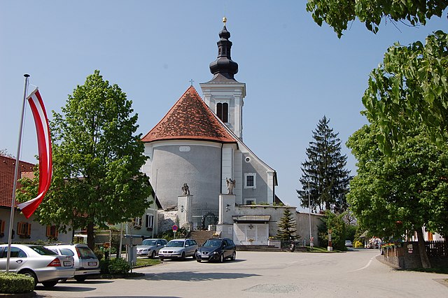
Sankt Veit in der Südsteiermark
- municipality in Austria
Hiking in Sankt Veit in der Südsteiermark
Sankt Veit in der Südsteiermark is a charming town in Austria known for its picturesque landscapes and extensive hiking opportunities. Nestled in the rolling hills of Styria, this area offers a mix of gentle walks and more challenging hikes, catering to various fitness levels and preferences....
- Country:
- Postal Code: 8421, 8422, 8423, 8435, 8481
- Licence Plate Code: LB
- Coordinates: 46° 44' 52" N, 15° 37' 36" E
- GPS tracks (wikiloc): [Link]
- AboveSeaLevel: 260 м m
- Area: 68.67 sq km
- Population: 4062
- Web site: [Link]
Schwarzautal
- municipality in Austria
Hiking in Schwarzautal
Schwarzautal, located in the Styria region of Austria, is a picturesque area known for its beautiful landscapes and hiking opportunities. The region is characterized by rolling hills, lush forests, vineyards, and charming villages, making it a delightful destination for hikers of all levels....
- Country:
- Postal Code: 8413, 8421, 8422
- Licence Plate Code: LB
- Coordinates: 46° 49' 48" N, 15° 40' 48" E
- GPS tracks (wikiloc): [Link]
- AboveSeaLevel: 304 м m
- Area: 40.22 sq km
- Population: 2310
- Web site: [Link]
Ehrenhausen an der Weinstraße
- municipality in Austria
Hiking in Ehrenhausen an der Weinstraße
Ehrenhausen an der Weinstraße, located in the picturesque wine region of Styria in Austria, offers beautiful hiking opportunities that allow you to explore both the natural landscape and the local viticulture. Here are some highlights and tips for hiking in and around this charming village:...
- Country:
- Postal Code: 8461
- Local Dialing Code: 03453
- Licence Plate Code: LB
- Coordinates: 46° 43' 35" N, 15° 35' 4" E
- GPS tracks (wikiloc): [Link]
- AboveSeaLevel: 258 м m
- Area: 20.31 sq km
- Population: 2558
- Web site: [Link]
Leutschach an der Weinstraße
- municipality in Austria
Hiking in Leutschach an der Weinstraße
Leutschach an der Weinstraße is a charming village located in the beautiful wine-growing region of Styria, Austria. This area offers a variety of hiking opportunities, showcasing the scenic vineyards, rolling hills, and picturesque landscapes that define the region....
- Country:
- Postal Code: 8452, 8453, 8454, 8462, 8463
- Local Dialing Code: 03454
- Licence Plate Code: LB
- Coordinates: 46° 40' 1" N, 15° 28' 4" E
- GPS tracks (wikiloc): [Link]
- AboveSeaLevel: 352 м m
- Area: 75.74 sq km
- Population: 3723
- Web site: [Link]


Gralla
- municipality in Austria
Hiking in Gralla
Gralla is a small village located in Slovenia, within the municipality of Slovenska Bistrica. The area surrounding Gralla offers a charming landscape suited for hiking, especially for those who enjoy peaceful countryside views and exploring the natural beauty of the region....
- Country:
- Postal Code: 8431
- Local Dialing Code: 03452
- Licence Plate Code: LB
- Coordinates: 46° 49' 18" N, 15° 33' 49" E
- GPS tracks (wikiloc): [Link]
- AboveSeaLevel: 278 м m
- Area: 12.14 sq km
- Population: 2390
- Web site: [Link]
Wolfsberg im Schwarzautal
- former municipality in Austria
Hiking in Wolfsberg im Schwarzautal
Wolfsberg im Schwarzautal is a picturesque municipality in Styria, Austria, surrounded by beautiful landscapes and rolling hills. The area offers a variety of hiking trails that cater to different skill levels, making it a great destination for both novice and experienced hikers....
- Country:
- Postal Code: 8421
- Local Dialing Code: 03184
- Licence Plate Code: LB
- Coordinates: 46° 50' 45" N, 15° 39' 36" E
- GPS tracks (wikiloc): [Link]
- AboveSeaLevel: 304 м m
- Area: 10.5 sq km
Pistorf
- former municipality in Austria
Hiking in Pistorf
Pistorf, a small town located in Styria, Austria, offers a variety of scenic hiking opportunities amid beautiful landscapes, rolling hills, and lush greenery. While it may not be as well-known as some other Austrian hiking destinations, it provides a great chance for hikers looking for tranquility and a connection to nature....
- Country:
- Local Dialing Code: 03457
- Licence Plate Code: LB
- Coordinates: 46° 45' 57" N, 15° 22' 23" E
- GPS tracks (wikiloc): [Link]
- AboveSeaLevel: 312 м m
- Area: 13.57 sq km
- Population: 1402
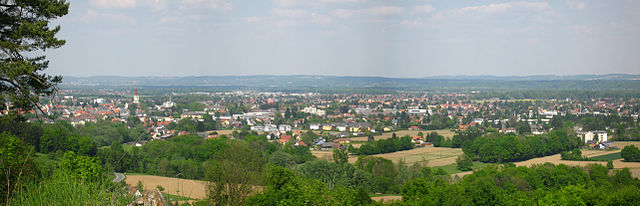
Leibnitz
- city in Styria
Hiking in Leibnitz
Leibnitz, located in Styria, Austria, is a delightful region for hiking enthusiasts. The area is characterized by its rolling hills, vineyards, and picturesque landscapes, offering a variety of trails suitable for different skill levels. Here are some highlights and tips for hiking in Leibnitz:...
- Country:
- Postal Code: 8430, 8435, 8451, 8462
- Local Dialing Code: 03452
- Coordinates: 46° 46' 59" N, 15° 32' 42" E
- GPS tracks (wikiloc): [Link]
- AboveSeaLevel: 275 м m
- Area: 23.53 sq km
- Population: 12176
- Web site: [Link]
Seggauberg
- former municipality in Austria
Hiking in Seggauberg
Seggauberg is a beautiful area in Austria, located in the Styria region, near the town of Leibnitz. Known for its scenic landscapes, vineyards, and rolling hills, it offers several excellent hiking opportunities suitable for various skill levels....
- Country:
- Postal Code: 8430, 8435, 8451, 8462
- Local Dialing Code: 03452
- Licence Plate Code: LB
- Coordinates: 46° 45' 29" N, 15° 31' 26" E
- GPS tracks (wikiloc): [Link]
- AboveSeaLevel: 368 м m
- Area: 11.02 sq km
- Population: 951

Spielfeld
- former municipality in Austria
Hiking in Spielfeld
Spielfeld is a charming area located in Austria, near the border with Slovenia. It's known for its beautiful landscapes, making it a great destination for hiking enthusiasts. Here are some key points to consider if you're planning to hike in Spielfeld:...
- Country:
- Postal Code: 8471
- Local Dialing Code: 03453
- Licence Plate Code: LB
- Coordinates: 46° 42' 1" N, 15° 37' 42" E
- GPS tracks (wikiloc): [Link]
- AboveSeaLevel: 277 м m
- Area: 10.11 sq km
- Population: 992

Gamlitz
- municipality in Austria
Hiking in Gamlitz
Gamlitz, located in the Styria region of Austria, offers a unique hiking experience amid picturesque landscapes, vineyards, and charming villages. Here are some highlights and tips for hiking in the area:...
- Country:
- Local Dialing Code: 03453
- Licence Plate Code: LB
- Coordinates: 46° 43' 13" N, 15° 33' 12" E
- GPS tracks (wikiloc): [Link]
- AboveSeaLevel: 278 м m
- Area: 34.51 sq km
- Population: 3248
- Web site: [Link]
Lebring-Sankt Margarethen
- municipality in Austria
Hiking in Lebring-Sankt Margarethen
Lebring-Sankt Margarethen is a picturesque region in the Styria province of Austria, known for its beautiful landscapes and outdoor recreational opportunities. When it comes to hiking, this area offers a mix of scenic routes suitable for various skill levels, all set against the backdrop of rolling hills and lush greenery....
- Country:
- Postal Code: 8403
- Local Dialing Code: 03182
- Licence Plate Code: LB
- Coordinates: 46° 51' 49" N, 15° 31' 40" E
- GPS tracks (wikiloc): [Link]
- AboveSeaLevel: 286 м m
- Area: 7.59 sq km
- Population: 2168
- Web site: [Link]
Wildon
- municipality in Austria
Hiking in Wildon
Wildon is a charming village located in Styria, Austria, which offers some lovely hiking opportunities amidst picturesque landscapes. Here are some details about hiking in and around Wildon:...
- Country:
- Postal Code: 8410
- Local Dialing Code: 03182
- Licence Plate Code: LB
- Coordinates: 46° 53' 13" N, 15° 30' 51" E
- GPS tracks (wikiloc): [Link]
- AboveSeaLevel: 314 м m
- Area: 7.24 sq km
- Population: 5367
- Web site: [Link]
Sankt Johann im Saggautal
- municipality in Austria
Hiking in Sankt Johann im Saggautal
Sankt Johann im Saggautal, located in the Austrian region of Styria, offers hikers an enchanting experience with its picturesque landscapes, lush vineyards, and beautiful rolling hills. Here are some highlights to consider when hiking in this charming area:...
- Country:
- Local Dialing Code: 03455
- Licence Plate Code: LB
- Coordinates: 46° 42' 8" N, 15° 24' 2" E
- GPS tracks (wikiloc): [Link]
- AboveSeaLevel: 316 м m
- Area: 26.98 sq km
- Population: 2023
- Web site: [Link]
Sulztal an der Weinstraße
- former municipality in Austria
Hiking in Sulztal an der Weinstraße
Sulztal an der Weinstraße is a charming destination located in the heart of the South Styrian Wine Road (Südsteirische Weinstraße) in Austria. This area is renowned for its picturesque vineyards, rolling hills, and stunning views, making it a fantastic spot for hiking enthusiasts....
- Country:
- Postal Code: 8461
- Local Dialing Code: 03453
- Licence Plate Code: LB
- Coordinates: 46° 40' 42" N, 15° 33' 17" E
- GPS tracks (wikiloc): [Link]
- AboveSeaLevel: 505 м m
- Area: 2.28 sq km
- Population: 126
Eichberg-Trautenburg
- former municipality in Austria
Hiking in Eichberg-Trautenburg
Eichberg-Trautenburg is a picturesque area located in Austria, known for its stunning landscapes, rolling hills, and diverse hiking trails. Here are some key points to consider when planning a hiking trip there:...
- Country:
- Postal Code: 8452, 8453, 8454, 8463
- Local Dialing Code: 03454
- Licence Plate Code: LB
- Coordinates: 46° 41' 28" N, 15° 27' 22" E
- GPS tracks (wikiloc): [Link]
- AboveSeaLevel: 480 м m
- Area: 21.2 sq km
- Population: 773
Breitenfeld am Tannenriegel
- former municipality in Austria
Hiking in Breitenfeld am Tannenriegel
Breitenfeld am Tannenriegel is a charming area in Austria that offers beautiful hiking opportunities amidst scenic landscapes. Nestled in the heart of nature, this region is known for its lush forests, rolling hills, and diverse wildlife....
- Country:
- Postal Code: 8421
- Local Dialing Code: 03184
- Licence Plate Code: LB
- Coordinates: 46° 51' 0" N, 15° 37' 48" E
- GPS tracks (wikiloc): [Link]
- AboveSeaLevel: 310 м m
- Area: 4.41 sq km
Hainsdorf im Schwarzautal
- former municipality in Austria
Hiking in Hainsdorf im Schwarzautal
Hainsdorf im Schwarzautal is a charming village located in Austria's Styria region, nestled amidst picturesque landscapes that are perfect for hiking enthusiasts. The area is characterized by rolling hills, lush forests, vineyards, and small streams. Here are some highlights and tips for hiking in this region:...
- Country:
- Postal Code: 8421
- Local Dialing Code: 03184
- Licence Plate Code: LB
- Coordinates: 46° 50' 1" N, 15° 38' 17" E
- GPS tracks (wikiloc): [Link]
- AboveSeaLevel: 284 м m
- Area: 6.63 sq km
Sankt Nikolai ob Draßling
- former municipality in Austria
Hiking in Sankt Nikolai ob Draßling
Sankt Nikolai ob Draßling, located in Austria, is an idyllic village set amidst the stunning scenery of the Styrian region, making it an excellent destination for hiking enthusiasts. The area is characterized by its rolling hills, lush forests, and panoramic views of the surrounding mountains....
- Country:
- Local Dialing Code: 03184
- Licence Plate Code: LB
- Coordinates: 46° 48' 56" N, 15° 39' 37" E
- GPS tracks (wikiloc): [Link]
- AboveSeaLevel: 333 м m
- Area: 17.56 sq km
Sankt Veit am Vogau
- former municipality in Austria
Hiking in Sankt Veit am Vogau
Sankt Veit am Vogau is a charming locale in Austria, located in the Styria region, renowned for its beautiful landscapes and outdoor activities, including hiking. If you're considering hiking in this area, here are some highlights:...
- Country:
- Local Dialing Code: 03453
- Licence Plate Code: LB
- Coordinates: 46° 44' 52" N, 15° 37' 36" E
- GPS tracks (wikiloc): [Link]
- AboveSeaLevel: 260 м m
- Area: 25.9 sq km


Ratsch an der Weinstraße
- former municipality in Austria
Hiking in Ratsch an der Weinstraße
Ratsch an der Weinstraße is a charming village located in the South Styrian wine region of Austria. The area is known for its picturesque landscapes, rolling vineyards, and scenic hills, making it an excellent destination for hiking enthusiasts....
- Country:
- Postal Code: 8461
- Local Dialing Code: 03454
- Licence Plate Code: LB
- Coordinates: 46° 42' 0" N, 15° 34' 12" E
- GPS tracks (wikiloc): [Link]
- AboveSeaLevel: 352 м m
- Population: 331
Schloßberg
- former municipality in Austria
Hiking in Schloßberg
Schloßberg in Leibnitz, Austria, is a picturesque hill that offers hiking opportunities with rewarding views and a touch of history. This location is known for its beautiful vineyards, rolling hills, and charming landscapes typical of the Styria region....
- Country:
- Postal Code: 8463
- Local Dialing Code: 03454
- Coordinates: 46° 38' 58" N, 15° 28' 6" E
- GPS tracks (wikiloc): [Link]
- AboveSeaLevel: 346 м m
- Area: 29.31 sq km
- Population: 1076
Stocking
- former municipality in Austria
Hiking in Stocking
Stocking, located in Styria, Austria, is a picturesque area known for its stunning natural landscapes and excellent hiking opportunities. Styria, or Steiermark, is characterized by its rolling hills, lush forests, and charming alpine scenery. Here are some key points to consider if you're planning to hike in this region:...
- Country:
- Local Dialing Code: 03182
- Licence Plate Code: LB
- Coordinates: 46° 53' 12" N, 15° 32' 11" E
- GPS tracks (wikiloc): [Link]
- AboveSeaLevel: 294 м m
- Area: 16.45 sq km
- Population: 1455
Vogau
- former municipality in Austria
Hiking in Vogau
Vogau, located in the scenic region of Styria in Austria, offers a variety of hiking opportunities that allow adventurers to explore its lush landscapes, vineyards, and charming countryside. Here are some highlights for hiking in this area:...
- Country:
- Postal Code: 8472
- Local Dialing Code: 03453
- Coordinates: 46° 43' 53" N, 15° 36' 8" E
- GPS tracks (wikiloc): [Link]
- AboveSeaLevel: 255 м m
- Area: 6.06 sq km
- Population: 1115
Glanz an der Weinstraße
- former municipality in Austria
Hiking in Glanz an der Weinstraße
Glanz an der Weinstraße is a picturesque town located in the Styria region of Austria, nestled in the beautiful wine-producing landscape. Hiking in this area offers a unique blend of stunning natural beauty, rich cultural heritage, and the opportunity to explore charming vineyards....
- Country:
- Postal Code: 8463
- Local Dialing Code: 03454
- Licence Plate Code: LB
- Coordinates: 46° 39' 29" N, 15° 31' 4" E
- GPS tracks (wikiloc): [Link]
- AboveSeaLevel: 440 м m
- Area: 23.98 sq km
- Population: 1396
Empersdorf
- municipality in Austria
Hiking in Empersdorf
Empersdorf is a picturesque area located in Austria, known for its charming landscapes and outdoor activities. While it may not be a widely recognized hiking destination, the surrounding region offers a variety of trails suitable for different skill levels. Here are some aspects to consider if you’re planning to hike in and around Empersdorf:...
- Country:
- Local Dialing Code: 03134
- Licence Plate Code: LB
- Coordinates: 47° 0' 1" N, 15° 36' 14" E
- GPS tracks (wikiloc): [Link]
- AboveSeaLevel: 360 м m
- Area: 14.17 sq km
- Population: 1376
- Web site: [Link]
Sankt Georgen an der Stiefing
- municipality in Austria
Hiking in Sankt Georgen an der Stiefing
Sankt Georgen an der Stiefing is a picturesque municipality located in Styria, Austria. It offers a variety of hiking opportunities characterized by beautiful landscapes, rolling hills, and scenic countryside. Here are some highlights to consider if you're planning to hike in this region:...
- Country:
- Postal Code: 8413
- Local Dialing Code: 03183
- Licence Plate Code: LB
- Coordinates: 46° 52' 32" N, 15° 34' 39" E
- GPS tracks (wikiloc): [Link]
- AboveSeaLevel: 319 м m
- Area: 13.87 sq km
- Population: 1475
- Web site: [Link]


Ragnitz
- municipality in Austria
Hiking in Ragnitz
Ragnitz is a beautiful area located in Austria, known for its picturesque landscapes and outdoor recreational opportunities. While it might not be as widely recognized as some major hiking destinations, it offers various trails suitable for hikers of all skill levels....
- Country:
- Postal Code: 8413
- Local Dialing Code: 03183
- Licence Plate Code: LB
- Coordinates: 46° 51' 0" N, 15° 34' 12" E
- GPS tracks (wikiloc): [Link]
- AboveSeaLevel: 281 м m
- Area: 20.77 sq km
- Population: 1469
- Web site: [Link]

Sankt Andrä-Höch
- municipality in Austria
Hiking in Sankt Andrä-Höch
Sankt Andrä-Höch, located in Austria's Styria region, offers beautiful landscapes ideal for hiking enthusiasts. Nestled amidst rolling hills and lush forests, this area is known for its serene environment and scenic views....
- Country:
- Licence Plate Code: LB
- Coordinates: 46° 47' 33" N, 15° 22' 46" E
- GPS tracks (wikiloc): [Link]
- AboveSeaLevel: 356 м m
- Area: 20.6 sq km
- Population: 1731
- Web site: [Link]
Retznei
- former municipality in Austria
Hiking in Retznei
Retznei is a small village located in Styria, Austria, known for its beautiful landscapes and access to various outdoor activities, including hiking. The region offers a mix of gentle hills, vineyards, and breathtaking views of the surrounding countryside, making it an ideal spot for hikers of all skill levels....
- Country:
- Postal Code: 8461
- Local Dialing Code: 03453
- Licence Plate Code: LB
- Coordinates: 46° 44' 14" N, 15° 34' 10" E
- GPS tracks (wikiloc): [Link]
- AboveSeaLevel: 261 м m
- Area: 3.34 sq km
- Population: 393
Sankt Nikolai im Sausal
- municipality in Austria
Hiking in Sankt Nikolai im Sausal
Sankt Nikolai im Sausal is a picturesque village located in the Styrian region of Austria, surrounded by beautiful hills and natural landscapes. This area offers a variety of hiking opportunities, making it an appealing destination for both beginner and experienced hikers....
- Country:
- Postal Code: 8505
- Local Dialing Code: 03185
- Licence Plate Code: LB
- Coordinates: 46° 49' 16" N, 15° 26' 57" E
- GPS tracks (wikiloc): [Link]
- AboveSeaLevel: 342 м m
- Area: 26.18 sq km
- Population: 2257
- Web site: [Link]
Gabersdorf
- municipality in Austria
Hiking in Gabersdorf
Gabersdorf, located in the scenic region of Styria in Austria, is an excellent destination for hiking enthusiasts. The area offers a variety of trails that range from easy walking paths suitable for families to more challenging hikes for experienced trekkers. Here are some key points about hiking in Gabersdorf:...
- Country:
- Postal Code: 8424
- Local Dialing Code: 03452
- Licence Plate Code: LB
- Coordinates: 46° 46' 55" N, 15° 35' 13" E
- GPS tracks (wikiloc): [Link]
- AboveSeaLevel: 274 м m
- Area: 19.81 sq km
- Population: 1227
- Web site: [Link]

Gleinstätten
- municipality in Austria
Hiking in Gleinstätten
Gleinstätten, located in Styria, Austria, is surrounded by beautiful natural landscapes that make it an excellent destination for hiking enthusiasts. The area features a mix of rolling hills, lush forests, and scenic countryside, offering a variety of trails suitable for different skill levels. Here are some highlights and recommendations for hiking in Gleinstätten:...
- Country:
- Postal Code: 8443
- Local Dialing Code: 03457
- Licence Plate Code: LB
- Coordinates: 46° 45' 13" N, 15° 22' 11" E
- GPS tracks (wikiloc): [Link]
- AboveSeaLevel: 308 м m
- Area: 21.9 sq km
- Population: 2792
- Web site: [Link]

Straß in Steiermark
- municipality in Austria
Hiking in Straß in Steiermark
Straß in Steiermark, nestled in the picturesque region of Styria, Austria, offers a beautiful backdrop for hiking enthusiasts. The area is characterized by its rolling hills, lush forests, and stunning views of the surrounding mountains, making it an ideal setting for both casual walkers and serious trekkers....
- Country:
- Local Dialing Code: 03453
- Licence Plate Code: LB
- Coordinates: 46° 43' 38" N, 15° 37' 28" E
- GPS tracks (wikiloc): [Link]
- AboveSeaLevel: 254 м m
- Area: 28.90 sq km
- Population: 4852
- Web site: [Link]
Berghausen
- former municipality in Austria
Hiking in Berghausen
Berghausen, located in Styria, Austria, offers a variety of hiking opportunities that showcase the region's natural beauty, picturesque landscapes, and cultural heritage. Here are some highlights and tips for hiking in this charming area:...
- Country:
- Postal Code: 8461
- Local Dialing Code: 03453
- Licence Plate Code: LB
- Coordinates: 46° 42' 27" N, 15° 35' 50" E
- GPS tracks (wikiloc): [Link]
- AboveSeaLevel: 350 м m
- Area: 5.63 sq km
- Population: 596
Wagna
- municipality in Austria
Hiking in Wagna
Wagna is a charming area located in Styria, Austria. It is known for its beautiful landscapes, vineyards, and proximity to natural attractions, making it a great destination for hiking enthusiasts....
- Country:
- Local Dialing Code: 03452
- Licence Plate Code: LB
- Coordinates: 46° 46' 5" N, 15° 33' 30" E
- GPS tracks (wikiloc): [Link]
- AboveSeaLevel: 266 м m
- Area: 12.98 sq km
- Population: 5859
- Web site: [Link]
Arnfels
- municipality in Austria
Hiking in Arnfels
Arnfels is a picturesque small town located in the Austrian state of Styria, surrounded by beautiful landscapes and rolling hills. It offers various hiking opportunities that cater to different skill levels, making it a great destination for outdoor enthusiasts....
- Country:
- Postal Code: 8454
- Local Dialing Code: 03455
- Licence Plate Code: LB
- Coordinates: 46° 40' 35" N, 15° 24' 11" E
- GPS tracks (wikiloc): [Link]
- AboveSeaLevel: 317 м m
- Area: 4.21 sq km
- Population: 1013
- Web site: [Link]

Lang
- municipality in Austria
Hiking in Lang
Lang, a picturesque area in Styria, Austria, offers a variety of hiking opportunities, making it a remarkable destination for outdoor enthusiasts. The region features stunning landscapes, rolling hills, lush forests, and scenic views of the surrounding mountains....
- Country:
- Postal Code: 8403
- Local Dialing Code: 03182
- Licence Plate Code: LB
- Coordinates: 46° 50' 14" N, 15° 30' 10" E
- GPS tracks (wikiloc): [Link]
- AboveSeaLevel: 286 м m
- Area: 15.66 sq km
- Population: 1325
- Web site: [Link]
Hengsberg
- municipality in Austria
Hiking in Hengsberg
Hengsberg is a scenic region located in Austria, known for its picturesque landscapes and outdoor activities, including hiking. The area offers a variety of trails suitable for different skill levels, so whether you’re a beginner or an experienced hiker, you can find routes that will suit your needs....
- Country:
- Postal Code: 8403, 8411, 8504
- Local Dialing Code: 03185
- Licence Plate Code: LB
- Coordinates: 46° 52' 7" N, 15° 27' 1" E
- GPS tracks (wikiloc): [Link]
- AboveSeaLevel: 351 м m
- Area: 17.75 sq km
- Population: 1445
- Web site: [Link]
Obervogau
- former municipality in Austria
Hiking in Obervogau
Obervogau is a charming village located in the Styria region of Austria, surrounded by beautiful natural landscapes that are perfect for hiking enthusiasts. The area is characterized by rolling hills, vineyards, and scenic views, making it an ideal destination for outdoor activities....
- Country:
- Postal Code: 8461, 8472
- Local Dialing Code: 03453
- Licence Plate Code: LB
- Coordinates: 46° 44' 49" N, 15° 35' 0" E
- GPS tracks (wikiloc): [Link]
- AboveSeaLevel: 260 м m
- Area: 3.95 sq km
- Population: 862
Oberhaag
- municipality in Austria
Hiking in Oberhaag
Oberhaag is a charming area in Austria, often characterized by its beautiful landscapes, picturesque trails, and rich natural surroundings. While specific trails may vary, I can offer general advice and highlights for hiking in this region....
- Country:
- Postal Code: 8455
- Local Dialing Code: 03455
- Licence Plate Code: LB
- Coordinates: 46° 41' 10" N, 15° 19' 52" E
- GPS tracks (wikiloc): [Link]
- AboveSeaLevel: 323 м m
- Area: 35.89 sq km
- Population: 2136
- Web site: [Link]


Heimschuh
- municipality in Austria
Hiking in Heimschuh
Heimschuh, located in Austria, offers a charming environment for hiking enthusiasts. This small town is situated in the scenic region of Styria, known for its lush landscapes, rolling hills, and vineyards. When planning a hiking trip in Heimschuh, consider the following:...
- Country:
- Postal Code: 8451
- Local Dialing Code: 03452
- Licence Plate Code: LB
- Coordinates: 46° 45' 12" N, 15° 29' 18" E
- GPS tracks (wikiloc): [Link]
- AboveSeaLevel: 280 м m
- Area: 18.52 sq km
- Population: 1968
- Web site: [Link]
Heiligenkreuz am Waasen
- municipality in Austria
Hiking in Heiligenkreuz am Waasen
Heiligenkreuz am Waasen is a charming village located in Austria, known for its picturesque landscapes and serene hiking paths. Situated in the Styria region, it serves as a great starting point for various hiking adventures....
- Country:
- Licence Plate Code: LB
- Coordinates: 46° 57' 23" N, 15° 35' 6" E
- GPS tracks (wikiloc): [Link]
- AboveSeaLevel: 329 м m
- Area: 15.4 sq km
- Population: 2787
- Web site: [Link]
Weitendorf
- former municipality in Austria
Hiking in Weitendorf
Weitendorf, located in the Styria region of Austria, offers a picturesque landscape ideal for hiking enthusiasts. The area is characterized by rolling hills, lush forests, and beautiful meadows, making it a great spot for both beginner and experienced hikers....
- Country:
- Postal Code: 8410
- Local Dialing Code: 03182
- Coordinates: 46° 53' 51" N, 15° 28' 1" E
- GPS tracks (wikiloc): [Link]
- AboveSeaLevel: 317 м m
- Area: 13.89 sq km
- Population: 1583

Ehrenhausen
- former municipality in Austria
Hiking in Ehrenhausen
Ehrenhausen is a picturesque village located in Styria, Austria, known for its beautiful landscapes and charming vineyards along the banks of the Mur River. Hiking in this region offers a delightful mix of natural beauty, cultural experiences, and opportunities to explore the local flora and fauna....
- Country:
- Postal Code: 8461
- Local Dialing Code: 03453
- Licence Plate Code: LB
- Coordinates: 46° 43' 19" N, 15° 35' 13" E
- GPS tracks (wikiloc): [Link]
- AboveSeaLevel: 262 м m


Großklein
- municipality in Austria
Hiking in Großklein
Großklein, located in Styria in Austria, offers a charming environment for hiking enthusiasts. The region is characterized by picturesque landscapes, rolling hills, vineyards, and various trails suitable for different skill levels. Here are some highlights and tips for hiking in Großklein:...
- Country:
- Local Dialing Code: 03456
- Licence Plate Code: LB
- Coordinates: 46° 44' 11" N, 15° 26' 34" E
- GPS tracks (wikiloc): [Link]
- AboveSeaLevel: 364 м m
- Area: 27.78 sq km
- Population: 2292
- Web site: [Link]
Allerheiligen bei Wildon
- municipality in Austria
Hiking in Allerheiligen bei Wildon
Allerheiligen bei Wildon is a charming area in Styria, Austria, known for its picturesque landscapes and outdoor activities, including hiking. Here are some key points to consider if you're planning a hiking trip there:...
- Country:
- Postal Code: 8412
- Local Dialing Code: 03182
- Licence Plate Code: LB
- Coordinates: 46° 54' 51" N, 15° 33' 14" E
- GPS tracks (wikiloc): [Link]
- AboveSeaLevel: 407 м m
- Area: 20.3 sq km
- Population: 1470
- Web site: [Link]
Kaindorf an der Sulm
- former municipality in Austria
Hiking in Kaindorf an der Sulm
Kaindorf an der Sulm is a picturesque village located in the Styria region of Austria, known for its stunning landscapes, rolling hills, and scenic vineyards. While it may not be as widely recognized as some larger tourist destinations, it offers a lovely environment for hiking enthusiasts....
- Country:
- Postal Code: 8430
- Local Dialing Code: 03452
- Coordinates: 46° 48' 0" N, 15° 32' 0" E
- GPS tracks (wikiloc): [Link]
- AboveSeaLevel: 340 м m
- Area: 6.55 sq km
- Population: 2552

Kitzeck im Sausal
- municipality in Austria
Hiking in Kitzeck im Sausal
Kitzeck im Sausal is a charming village located in Styria, Austria, and is renowned for its picturesque landscapes and wine-growing region. It offers a variety of hiking opportunities suitable for different skill levels. Here are some details that might help you enjoy your hiking experience in Kitzeck im Sausal:...
- Country:
- Postal Code: 8441, 8442, 8451
- Local Dialing Code: 03456
- Licence Plate Code: LB
- Coordinates: 46° 46' 52" N, 15° 27' 12" E
- GPS tracks (wikiloc): [Link]
- AboveSeaLevel: 564 м m
- Area: 16.29 sq km
- Population: 1228
- Web site: [Link]

Leutschach
- former municipality in Austria
Hiking in Leutschach
Leutschach is a beautiful region located in Styria, Austria, known for its rolling hills, vineyards, and picturesque landscapes. It is an excellent destination for hikers of all levels. Here are some key points to consider if you're planning a hiking trip in Leutschach:...
- Country:
- Postal Code: 8463
- Local Dialing Code: 03454
- Licence Plate Code: LB
- Coordinates: 46° 40' 0" N, 15° 28' 0" E
- GPS tracks (wikiloc): [Link]
- AboveSeaLevel: 352 м m
- Population: 551
Tillmitsch
- municipality in Austria
Hiking in Tillmitsch
Tillmitsch is a charming village located in Styria, Austria, and offers a variety of hiking opportunities for enthusiasts of all skill levels. The region is characterized by picturesque landscapes, rolling hills, vineyards, and scenic views of the surrounding countryside....
- Country:
- Local Dialing Code: 03452
- Licence Plate Code: LB
- Coordinates: 46° 48' 41" N, 15° 30' 48" E
- GPS tracks (wikiloc): [Link]
- AboveSeaLevel: 276 м m
- Area: 14.99 sq km
- Population: 3284
- Web site: [Link]


Sankt Ulrich am Waasen
- former municipality in Austria
Hiking in Sankt Ulrich am Waasen
Sankt Ulrich am Waasen is a lovely area in Austria, known for its beautiful landscapes and outdoor activities, particularly hiking. While the region may not be as well-known as some of Austria’s larger hiking destinations, it offers a range of trails that cater to all skill levels....
- Country:
- Local Dialing Code: 03135
- Licence Plate Code: LB
- Coordinates: 46° 56' 56" N, 15° 32' 38" E
- GPS tracks (wikiloc): [Link]
- AboveSeaLevel: 394 м m
- Area: 10.0 sq km
- Population: 787
Shares border with regions:


Graz-Umgebung District
- district in Austria
Hiking in Graz-Umgebung District
Graz-Umgebung District, located around the city of Graz in Austria, offers a wide range of hiking opportunities, featuring scenic landscapes, lush forests, and picturesque hilltops. Here are some highlights and recommendations for hiking in this area:...
- Country:
- Capital: Graz
- Licence Plate Code: GU
- Coordinates: 47° 3' 43" N, 15° 24' 54" E
- GPS tracks (wikiloc): [Link]
- AboveSeaLevel: 522 м m
- Area: 1100.7 sq km
- Population: 148830
- Web site: [Link]