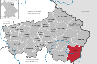
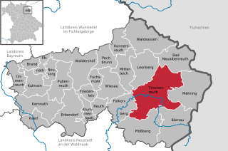
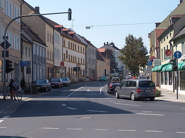
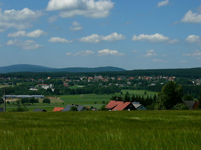
Tirschenreuth (Landkreis Tirschenreuth)

- district of Bavaria, Germany
 Hiking in Tirschenreuth
Tirschenreuth is a district in Bavaria, Germany, known for its picturesque landscapes, forests, and numerous hiking trails. If you're planning to hike in this district, here's what you need to know:
Scenic Trails
-
Nature Conservation Areas: Tirschenreuth boasts several nature conservation areas, such as the Fichtelgebirge region, which is characterized by rolling hills, rivers, and dense forests. The trails here allow for a variety of hiking experiences, from easy walks to more challenging treks.
-
Parks and Lakes: The district is home to numerous parks and lakes, such as the Waldnaab River Park and the numerous small lakes. Hiking around these areas provides beautiful views and opportunities for wildlife spotting.
-
Historical Paths: There are several routes that take you through the historical and cultural sites of Tirschenreuth. You can explore ancient ruins, churches, and local landmarks while enjoying nature.
Trail Difficulty
The hiking trails in Tirschenreuth vary in difficulty levels. Whether you are a beginner or an experienced hiker, you can find suitable paths. Many trails are well-marked, so navigation should be straightforward.
Recommendations
- Trail Maps: It’s advisable to carry a trail map or download a hiking app with GPS capability to help navigate the numerous paths.
- Respect Nature: As you hike, be mindful of the local environment. Stick to marked trails and respect wildlife and plant life.
- Safety Gear: Wear appropriate hiking footwear and bring water, snacks, and a first aid kit. The weather can change quickly, so dress in layers and be prepared.
Conclusion
Hiking in Tirschenreuth offers a blend of natural beauty and cultural history. It's an excellent destination for hikers seeking tranquility, scenic views, and the joy of exploring the outdoors in Bavaria, Germany.
- Country:

- Capital: Tirschenreuth
- Licence Plate Code: TIR; KEM
- Coordinates: 49° 54' 0" N, 12° 12' 0" E


- GPS tracks (wikiloc): [Link]
- AboveSeaLevel: 499 м m
- Area: 1085.08 sq km
- Population: 77865
- Web site: http://www.kreis-tir.de/
- Wikipedia en: wiki(en)
- Wikipedia: wiki(de)
- Wikidata storage: Wikidata: Q10419
- Wikipedia Commons Category: [Link]
- Freebase ID: [/m/02l3fp]
- GeoNames ID: Alt: [2822099]
- VIAF ID: Alt: [152486573]
- OSM relation ID: [62575]
- GND ID: Alt: [4060213-8]
- archINFORM location ID: [5672]
- Library of Congress authority ID: Alt: [n83213236]
- Quora topic ID: [Tirschenreuth]
- Historical Gazetteer (GOV) ID: [adm_139377]
- Bavarikon ID: [ODB_A00001905]
- NUTS code: [DE23A]
- German district key: 09377
Includes regions:
Bärnau
- municipality of Germany
Hiking in Bärnau
Bärnau, located in Bavaria, Germany, is a picturesque town that serves as a great starting point for hiking enthusiasts looking to explore the stunning landscapes of the surrounding region. The area is characterized by rolling hills, lush forests, and rich cultural history, making it an ideal destination for both casual walkers and seasoned hikers....
- Country:
- Postal Code: 95671
- Local Dialing Code: 09635
- Licence Plate Code: TIR
- Coordinates: 49° 48' 37" N, 12° 26' 10" E
- GPS tracks (wikiloc): [Link]
- AboveSeaLevel: 615 м m
- Area: 74.42 sq km
- Population: 3663
- Web site: [Link]
Lenauer Forst
- former unincorporated area in Germany
Hiking in Lenauer Forst
Lenauer Forst, located in Germany, is a beautiful forested area that offers a range of hiking opportunities. It's known for its lush greenery, diverse flora and fauna, and well-maintained trails. Here’s what you should know about hiking in Lenauer Forst:...
- Country:
- Coordinates: 49° 57' 0" N, 11° 51' 0" E
- GPS tracks (wikiloc): [Link]
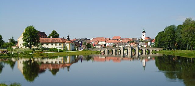
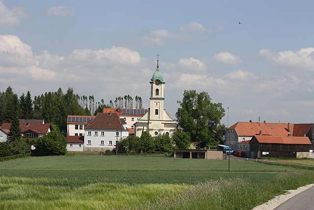
Tirschenreuth
- municipality of Germany
Hiking in Tirschenreuth
Tirschenreuth, located in Bavaria, Germany, is a lovely area for hiking enthusiasts. The region is characterized by its picturesque landscapes, including forests, hills, and charming villages. Here are some key points about hiking in Tirschenreuth:...
- Country:
- Postal Code: 95643
- Local Dialing Code: 09631
- Licence Plate Code: TIR
- Coordinates: 49° 52' 57" N, 12° 19' 59" E
- GPS tracks (wikiloc): [Link]
- AboveSeaLevel: 504 м m
- Area: 66.54 sq km
- Population: 8899
- Web site: [Link]

Waldsassen
- municipality of Germany
Hiking in Waldsassen
Waldsassen, located in the Bavaria region of Germany, is known for its picturesque landscapes and various hiking opportunities. Here’s what you can expect when hiking in this area:...
- Country:
- Postal Code: 95652
- Local Dialing Code: 09632
- Licence Plate Code: TIR
- Coordinates: 50° 0' 0" N, 12° 18' 0" E
- GPS tracks (wikiloc): [Link]
- AboveSeaLevel: 491 м m
- Area: 66.54 sq km
- Population: 6741
- Web site: [Link]


Mitterteich
- municipality of Germany
Hiking in Mitterteich
Mitterteich, located in Bavaria, Germany, offers a range of beautiful hiking trails that cater to different skill levels and preferences. The area is known for its picturesque landscapes, including rolling hills, woodlands, and serene lakes, providing a perfect backdrop for outdoor activities....
- Country:
- Postal Code: 95666
- Local Dialing Code: 09633
- Licence Plate Code: TIR
- Coordinates: 49° 56' 0" N, 12° 14' 0" E
- GPS tracks (wikiloc): [Link]
- AboveSeaLevel: 519 м m
- Area: 39.35 sq km
- Population: 6619
- Web site: [Link]

Reuth bei Erbendorf
- municipality in Bavaria, Germany
Hiking in Reuth bei Erbendorf
Reuth bei Erbendorf is a quaint town located in Bavaria, Germany, surrounded by scenic landscapes that make it an ideal destination for hiking enthusiasts. Here are some key highlights about hiking in and around Reuth bei Erbendorf:...
- Country:
- Postal Code: 92717
- Local Dialing Code: 09683; 09682; 09681
- Licence Plate Code: TIR
- Coordinates: 49° 51' 0" N, 12° 7' 0" E
- GPS tracks (wikiloc): [Link]
- AboveSeaLevel: 476 м m
- Area: 16.91 sq km
- Population: 1218
- Web site: [Link]

Erbendorf
- municipality of Germany
Hiking in Erbendorf
Erbendorf, a picturesque town in Bavaria, Germany, offers a great starting point for hiking enthusiasts looking to explore the scenic beauty of the region. Nestled in the northeastern part of Bavaria, near the border with the Czech Republic, Erbendorf features a variety of hiking trails suitable for different skill levels....
- Country:
- Postal Code: 92681
- Local Dialing Code: 09682
- Licence Plate Code: TIR
- Coordinates: 49° 50' 0" N, 12° 3' 0" E
- GPS tracks (wikiloc): [Link]
- AboveSeaLevel: 506 м m
- Area: 67.55 sq km
- Population: 5150
- Web site: [Link]


Waldershof
- municipality of Germany
Hiking in Waldershof
Waldershof, located in Bavaria, Germany, is a charming area for hiking enthusiasts. The region is known for its beautiful natural landscapes, including rolling hills, forests, and streams, making it an excellent destination for both casual walkers and more experienced hikers. Here are some key points about hiking in Waldershof:...
- Country:
- Postal Code: 95679
- Local Dialing Code: 09231
- Licence Plate Code: TIR
- Coordinates: 49° 58' 0" N, 12° 4' 0" E
- GPS tracks (wikiloc): [Link]
- AboveSeaLevel: 546 м m
- Area: 60.4 sq km
- Population: 4300
- Web site: [Link]


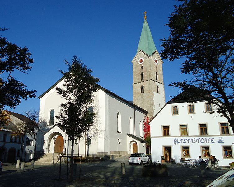
Kemnath
- town in Germany
Hiking in Kemnath
Kemnath is a picturesque town located in Bavaria, Germany, near the eastern edge of the Fichtelgebirge mountain range, which offers plenty of opportunities for hiking and outdoor activities. Here are some highlights and tips for hiking in and around Kemnath:...
- Country:
- Postal Code: 95478
- Local Dialing Code: 09642
- Coordinates: 49° 52' 0" N, 11° 53' 0" E
- GPS tracks (wikiloc): [Link]
- AboveSeaLevel: 462 м m
- Area: 56.8 sq km
- Population: 5317
- Web site: [Link]


Fuchsmühl
- municipality of Germany
Hiking in Fuchsmühl
Fuchsmühl is a quaint village located in Bavaria, Germany, surrounded by beautiful landscapes that are ideal for hiking enthusiasts. The region offers various trails that cater to different skill levels, from gentle walks through the picturesque countryside to more challenging hikes in the nearby forested areas....
- Country:
- Postal Code: 95689
- Local Dialing Code: 09634
- Licence Plate Code: TIR
- Coordinates: 49° 55' 0" N, 12° 9' 0" E
- GPS tracks (wikiloc): [Link]
- AboveSeaLevel: 624 м m
- Area: 14.84 sq km
- Population: 1566
- Web site: [Link]

Pullenreuth
- municipality of Germany
Hiking in Pullenreuth
Pullenreuth is a small village located in Bavaria, Germany, known for its picturesque landscapes and access to the beautiful natural surroundings of the Fichtelgebirge mountain range. Hiking in this area offers a variety of trails suitable for all skill levels, allowing hikers to explore lush forests, rolling hills, and stunning viewpoints....
- Country:
- Postal Code: 95704
- Local Dialing Code: 09234
- Licence Plate Code: TIR
- Coordinates: 49° 55' 0" N, 12° 0' 0" E
- GPS tracks (wikiloc): [Link]
- AboveSeaLevel: 542 м m
- Area: 43.16 sq km
- Population: 1983
- Web site: [Link]


Plößberg
- municipality of Germany
Hiking in Plößberg
Plößberg, located in Bavaria, Germany, is a charming area that offers various hiking opportunities amidst beautiful landscapes. The region is characterized by rolling hills, lush forests, and scenic views, making it a great destination for hikers of all levels....
- Country:
- Postal Code: 95703
- Local Dialing Code: 09636
- Licence Plate Code: TIR
- Coordinates: 49° 47' 0" N, 12° 18' 30" E
- GPS tracks (wikiloc): [Link]
- AboveSeaLevel: 600 м m
- Area: 74.21 sq km
- Population: 3186
- Web site: [Link]


Konnersreuth
- municipality of Germany
Hiking in Konnersreuth
Konnersreuth is a charming village located in the Bavarian Forest of Germany, offering a range of beautiful hiking opportunities. The region is known for its picturesque landscapes, dense forests, rolling hills, and a tranquil atmosphere, making it ideal for both casual walkers and more experienced hikers....
- Country:
- Postal Code: 95692
- Local Dialing Code: 09632
- Licence Plate Code: TIR
- Coordinates: 50° 1' 0" N, 12° 14' 0" E
- GPS tracks (wikiloc): [Link]
- AboveSeaLevel: 573 м m
- Area: 23.32 sq km
- Population: 1825
- Web site: [Link]
Immenreuth
- German municipality
Hiking in Immenreuth
Immenreuth is a small town located in Bavaria, Germany, known for its beautiful natural surroundings and scenic landscapes, making it a lovely destination for hiking enthusiasts. Here are some highlights and tips for hiking in the area:...
- Country:
- Postal Code: 95505
- Local Dialing Code: 09642
- Licence Plate Code: TIR
- Coordinates: 49° 53' 0" N, 11° 52' 0" E
- GPS tracks (wikiloc): [Link]
- AboveSeaLevel: 504 м m
- Area: 18.05 sq km
- Population: 1885
- Web site: [Link]

Neusorg
- municipality of Germany
Hiking in Neusorg
Neusorg is a charming village located in the Bavaria region of Germany, surrounded by picturesque landscapes and a variety of hiking trails. Hiking in this area offers a unique opportunity to experience the natural beauty of the region, including forests, hills, and scenic views....
- Country:
- Postal Code: 95700
- Local Dialing Code: 09234
- Licence Plate Code: TIR
- Coordinates: 49° 55' 0" N, 11° 58' 0" E
- GPS tracks (wikiloc): [Link]
- AboveSeaLevel: 573 м m
- Area: 17.85 sq km
- Population: 2159
- Web site: [Link]


Wiesau
- municipality of Germany
Hiking in Wiesau
Wiesau, located in Bavaria, Germany, is a picturesque small town surrounded by beautiful natural landscapes that are ideal for hiking enthusiasts. The region offers a variety of hiking trails suited for different skill levels, making it a great destination for both novice and experienced hikers. Here are some highlights and tips for hiking in and around Wiesau:...
- Country:
- Postal Code: 95676
- Local Dialing Code: 09634
- Licence Plate Code: TIR
- Coordinates: 49° 55' 0" N, 12° 10' 0" E
- GPS tracks (wikiloc): [Link]
- AboveSeaLevel: 528 м m
- Area: 42.72 sq km
- Population: 4020
- Web site: [Link]
Ebnath
- municipality of Germany
Hiking in Ebnath
Ebnath is a small village located in the state of Bavaria, Germany. It is surrounded by beautiful natural landscapes, making it a great destination for hiking enthusiasts. Here are some key highlights about hiking in and around Ebnath:...
- Country:
- Postal Code: 95683
- Local Dialing Code: 09234
- Licence Plate Code: TIR
- Coordinates: 49° 57' 0" N, 11° 55' 0" E
- GPS tracks (wikiloc): [Link]
- AboveSeaLevel: 537 м m
- Area: 11.03 sq km
- Population: 1495
- Web site: [Link]


Neualbenreuth
- municipality of Germany
Hiking in Neualbenreuth
Neualbenreuth is a picturesque village in Bavaria, Germany, known for its beautiful landscapes and hiking opportunities. Nestled in the border region with the Czech Republic, it offers a range of trails showcasing the area's natural beauty, including forests, mountains, and unique rock formations....
- Country:
- Postal Code: 95698
- Local Dialing Code: 09638
- Licence Plate Code: TIR
- Coordinates: 49° 58' 0" N, 12° 26' 0" E
- GPS tracks (wikiloc): [Link]
- AboveSeaLevel: 558 м m
- Area: 50.13 sq km
- Population: 1474
- Web site: [Link]


Krummennaab
- municipality of Germany
Hiking in Krummennaab
Krummennaab, located in Bavaria, Germany, is a great destination for hiking enthusiasts. The area surrounds the small village, and its natural beauty is characterized by rolling hills, dense forests, and scenic landscapes....
- Country:
- Postal Code: 92703
- Local Dialing Code: 09682
- Licence Plate Code: TIR
- Coordinates: 49° 49' 0" N, 12° 5' 0" E
- GPS tracks (wikiloc): [Link]
- AboveSeaLevel: 480 м m
- Area: 17.72 sq km
- Population: 1468
- Web site: [Link]
Pechbrunn
- municipality of Germany
Hiking in Pechbrunn
Pechbrunn, located in Bavaria, Germany, is a serene destination for hiking enthusiasts. Known for its picturesque landscapes and natural beauty, it offers various trails suitable for hikers of all experience levels. Here are some highlights and tips for hiking in the Pechbrunn area:...
- Country:
- Postal Code: 95701
- Local Dialing Code: 09231
- Licence Plate Code: TIR
- Coordinates: 49° 58' 0" N, 12° 10' 0" E
- GPS tracks (wikiloc): [Link]
- AboveSeaLevel: 560 м m
- Area: 26.46 sq km
- Population: 1615
- Web site: [Link]


Friedenfels
- municipality of Germany
Hiking in Friedenfels
Friedenfels is a scenic area located in the Saxon Switzerland region of Germany, which is known for its stunning landscapes, distinctive rock formations, and extensive hiking trails. Here are some key points to consider when hiking in Friedenfels:...
- Country:
- Postal Code: 95688
- Local Dialing Code: 09683
- Licence Plate Code: TIR
- Coordinates: 49° 52' 0" N, 12° 7' 0" E
- GPS tracks (wikiloc): [Link]
- AboveSeaLevel: 537 м m
- Area: 16.28 sq km
- Population: 1256
- Web site: [Link]


Kulmain
- municipality in the district of Tirschenreuth located north of Kemnath in Bavaria in Germany
Hiking in Kulmain
Kulmain, a picturesque village nestled in the Fichtel Mountains of Bavaria, Germany, offers a variety of hiking opportunities for outdoor enthusiasts. The region is known for its stunning landscapes, dense forests, and diverse flora and fauna....
- Country:
- Postal Code: 95508
- Local Dialing Code: 09642
- Licence Plate Code: TIR
- Coordinates: 49° 53' 0" N, 11° 54' 0" E
- GPS tracks (wikiloc): [Link]
- AboveSeaLevel: 485 м m
- Area: 32.29 sq km
- Population: 2303
- Web site: [Link]


Falkenberg
- municipality of Germany
Hiking in Falkenberg
Falkenberg, located in the Upper Palatinate region of Bavaria, Germany, offers a serene hiking experience characterized by its picturesque landscapes, rolling hills, and natural beauty. The area is known for its diverse terrain, which includes forests, meadows, and small streams, making it a great destination for outdoor enthusiasts....
- Country:
- Postal Code: 95685
- Local Dialing Code: 09637
- Licence Plate Code: TIR
- Coordinates: 49° 52' 0" N, 12° 13' 0" E
- GPS tracks (wikiloc): [Link]
- AboveSeaLevel: 464 м m
- Area: 39.41 sq km
- Population: 946
- Web site: [Link]


Mähring
- municipality of Germany
Hiking in Mähring
Mähring is a charming town located in the northern part of Bavaria, Germany, near the border with the Czech Republic. The area is known for its picturesque landscapes and diverse hiking trails that cater to various skill levels. Here are some highlights of hiking in Mähring:...
- Country:
- Postal Code: 95695
- Local Dialing Code: 09639
- Licence Plate Code: TIR
- Coordinates: 49° 55' 0" N, 12° 31' 0" E
- GPS tracks (wikiloc): [Link]
- AboveSeaLevel: 652 м m
- Area: 72.94 sq km
- Population: 1882
- Web site: [Link]


Leonberg
- community in Bavaria, Germany
Hiking in Leonberg
Leonberg is a picturesque area located in Bavaria, Germany, known for its beautiful landscapes, rolling hills, and charming towns. Hiking in this region offers a variety of trails that cater to different skill levels and preferences....
- Country:
- Postal Code: 95666
- Local Dialing Code: 09633
- Licence Plate Code: TIR
- Coordinates: 49° 57' 0" N, 12° 17' 0" E
- GPS tracks (wikiloc): [Link]
- AboveSeaLevel: 548 м m
- Area: 51.33 sq km
- Population: 1075
- Web site: [Link]

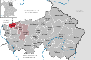
Brand
- municipality in the district of Tirschenreuth in Bavaria, Germany
Hiking in Brand
Brand, located in the beautiful region of Bavaria, Germany, is an excellent destination for hiking enthusiasts. Nestled near the Allgäu Alps, it offers a diverse range of trails that cater to various skill levels, from leisurely walks to challenging mountain hikes....
- Country:
- Postal Code: 95682
- Local Dialing Code: 09236
- Licence Plate Code: TIR
- Coordinates: 49° 57' 0" N, 11° 54' 0" E
- GPS tracks (wikiloc): [Link]
- AboveSeaLevel: 583 м m
- Area: 9.48 sq km
- Population: 1223
- Web site: [Link]


Kastl
- municipality in district Tirschenreuth, Bavaria, Germany
Hiking in Kastl
Kastl, located in the Tirschenreuth district of Bavaria, Germany, is surrounded by beautiful natural landscapes, making it an excellent spot for hiking enthusiasts. The region is characterized by its rolling hills, lush forests, and picturesque views of the Upper Palatinate area....
- Country:
- Postal Code: 95506
- Local Dialing Code: 09642
- Licence Plate Code: TIR
- Coordinates: 49° 49' 0" N, 11° 54' 0" E
- GPS tracks (wikiloc): [Link]
- AboveSeaLevel: 460 м m
- Area: 24.74 sq km
- Population: 1240
- Web site: [Link]
Shares border with regions:

Neustadt an der Waldnaab
- district of Bavaria, Germany
Hiking in Neustadt an der Waldnaab
Neustadt an der Waldnaab, located in the Upper Palatinate region of Bavaria, Germany, is known for its picturesque scenery and natural beauty, making it an excellent destination for hiking enthusiasts. Here are some highlights and insights into hiking in this area:...
- Country:
- Capital: Neustadt an der Waldnaab
- Licence Plate Code: VOH; NEW; ESB
- Coordinates: 49° 40' 12" N, 12° 0' 0" E
- GPS tracks (wikiloc): [Link]
- AboveSeaLevel: 450 м m
- Area: 1430.00 sq km
- Population: 94486
- Web site: [Link]

Wunsiedel
- district of Bavaria, Germany
Hiking in Wunsiedel
Wunsiedel is a picturesque district located in the Upper Franconia region of Bavaria, Germany. It's renowned for its beautiful landscapes, rich history, and a variety of hiking trails suitable for different skill levels. Here are some highlights of hiking in Wunsiedel:...
- Country:
- Licence Plate Code: SEL; REH; MAK; WUN
- Coordinates: 50° 5' 24" N, 12° 2' 24" E
- GPS tracks (wikiloc): [Link]
- AboveSeaLevel: 558 м m
- Area: 606.40 sq km
- Population: 87941
- Web site: [Link]

Bayreuth
- district in Bavaria, Germany
Hiking in Bayreuth
Bayreuth, located in the northern part of Bavaria, Germany, offers a diverse range of hiking opportunities set against a backdrop of beautiful landscapes, forests, and cultural sites. The region is known for its rich history, stunning scenery, and well-marked trails suitable for hikers of all levels....
- Country:
- Capital: Bayreuth
- Licence Plate Code: PEG; MÜB; KEM; ESB; EBS; BT
- Coordinates: 49° 55' 12" N, 11° 30' 0" E
- GPS tracks (wikiloc): [Link]
- AboveSeaLevel: 507 м m
- Area: 1273.00 sq km
- Population: 96772
- Web site: [Link]