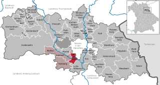
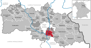
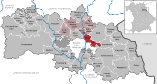
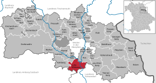
Neustadt an der Waldnaab (Landkreis Neustadt an der Waldnaab)

- district of Bavaria, Germany
 Hiking in Neustadt an der Waldnaab
Neustadt an der Waldnaab, located in the Upper Palatinate region of Bavaria, Germany, is known for its picturesque scenery and natural beauty, making it an excellent destination for hiking enthusiasts. Here are some highlights and insights into hiking in this area:
Trails and Nature
-
Diverse Landscapes: The district features a mix of forests, hills, rivers, and meadows, providing a variety of hiking experiences. The terrain is suitable for both leisurely walks and more challenging hikes.
-
Premium Walking Trails: Look out for designated hiking paths like the "Waldnaab Tal" – a beautiful trail that follows the Waldnaab River, offering stunning views of the landscape, lush forests, and tranquility.
-
Nature Reserves: The region is home to several protected areas where hikers can observe local flora and fauna. The nearby Oberpfälzer Wald (Upper Palatinate Forest) is particularly rich in biodiversity.
-
Cultural Attractions: Hiking routes can often lead to historical sites, charming villages, and cultural landmarks. Take some time to explore local castles or traditional Bavarian architecture along your hike.
Hiking Options
-
Day Hikes: Numerous day trails are available, varying in difficulty and lengths. Make sure to choose one that matches your fitness level and experience.
-
Themed Trails: Some trails are designed around themes, such as nature education or folklore, making for an engaging hiking experience.
-
Guided Tours: If you prefer a more informative experience, consider joining a guided hiking tour that can offer insights into local history and ecology.
Practical Considerations
-
Weather: The weather in Bavaria can be quite variable; always check forecasts and plan your hike accordingly. Bring appropriate clothing and gear for changing conditions.
-
Maps and Navigation: It's helpful to have a detailed map or a GPS device, as some trails might not be well-marked.
-
Local Amenities: Before heading out, familiarize yourself with the local amenities, such as parking, restrooms, and nearby eateries, especially if you'll be out for several hours.
-
Safety: Always let someone know your hiking plans and expected return time. Carry enough water and snacks, and be mindful of wildlife.
Conclusion
Neustadt an der Waldnaab offers a delightful hiking experience with its diverse trails, stunning scenery, and rich biodiversity. Whether you’re a seasoned hiker or a casual walker, this area provides a wonderful opportunity to immerse yourself in nature and explore the beauty of Bavaria.
- Country:

- Capital: Neustadt an der Waldnaab
- Licence Plate Code: VOH; NEW; ESB
- Coordinates: 49° 40' 12" N, 12° 0' 0" E


- GPS tracks (wikiloc): [Link]
- AboveSeaLevel: 450 м m
- Area: 1430.00 sq km
- Population: 94486
- Web site: http://www.neustadt.de/
- Wikipedia en: wiki(en)
- Wikipedia: wiki(de)
- Wikidata storage: Wikidata: Q10420
- Wikipedia Commons Category: [Link]
- Freebase ID: [/m/024f4p]
- GeoNames ID: Alt: [3220856]
- VIAF ID: Alt: [236352797]
- OSM relation ID: [975339]
- GND ID: Alt: [4041945-9]
- archINFORM location ID: [5322]
- TGN ID: [7077096]
- Historical Gazetteer (GOV) ID: [adm_139374]
- Bavarikon ID: [ODB_A00001790]
- NUTS code: [DE237]
- German district key: 09374
Includes regions:
Manteler Forst
- unincorporated area in Germany
Hiking in Manteler Forst
Manteler Forst, often referred to as Manteler Forest in English, is a captivating region that offers diverse hiking opportunities. It is located in Germany, near the border between the states of Bavaria and Thuringia, and is known for its beautiful landscapes, rich biodiversity, and serene environment....
- Country:
- Coordinates: 49° 40' 0" N, 12° 1' 0" E
- GPS tracks (wikiloc): [Link]
Heinersreuther Forst in Upper Palatinate
- unincorporated area in Germany
Hiking in Heinersreuther Forst in Upper Palatinate
Heinersreuther Forst, located in the Oberpfalz region of Bavaria, Germany, is a beautiful area for hiking enthusiasts. This forest offers a diverse landscape that includes dense woodlands, picturesque valleys, and streams, making it a great destination for both casual walkers and serious hikers....
- Country:
- Coordinates: 49° 45' 36" N, 11° 42' 0" E
- GPS tracks (wikiloc): [Link]


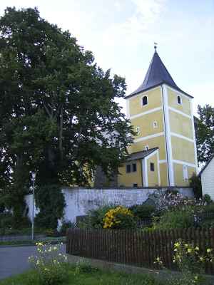
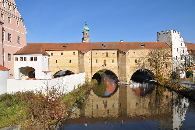
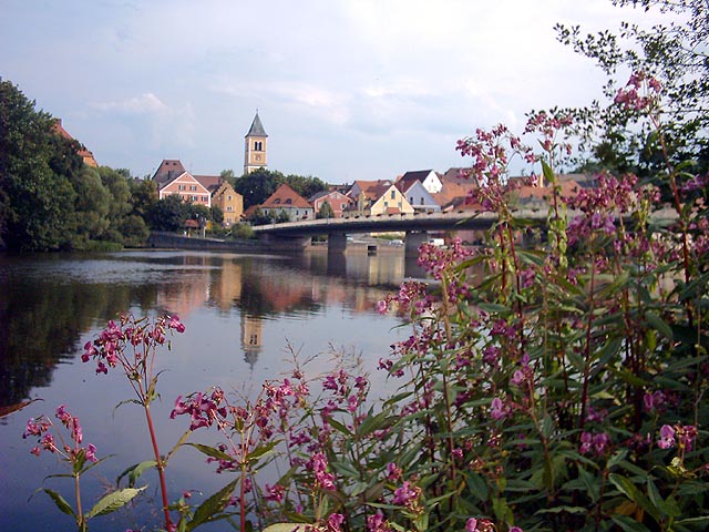
Schirmitz
- municipality of Germany
Hiking in Schirmitz
Schirmitz is a picturesque village located in Bavaria, Germany, known for its beautiful landscapes and proximity to the scenic wooded regions of the upper Palatinate. Hiking in this area can be a delightful experience, offering trails that range from easy walks to more challenging hikes....
- Country:
- Postal Code: 92718
- Local Dialing Code: 0961
- Licence Plate Code: NEW
- Coordinates: 49° 38' 0" N, 12° 10' 0" E
- GPS tracks (wikiloc): [Link]
- AboveSeaLevel: 393 м m
- Area: 4.97 sq km
- Population: 1624
- Web site: [Link]


Grafenwöhr
- municipality of Germany
Hiking in Grafenwöhr
Grafenwöhr, located in Bavaria, Germany, is known primarily as a military training area but also offers various opportunities for hiking enthusiasts. The surrounding landscape is characterized by rolling hills, forests, and scenic views, making it a great spot for outdoor activities....
- Country:
- Postal Code: 92655
- Local Dialing Code: 09641
- Licence Plate Code: NEW
- Coordinates: 49° 43' 0" N, 11° 54' 0" E
- GPS tracks (wikiloc): [Link]
- AboveSeaLevel: 410 м m
- Area: 216.21 sq km
- Population: 6521
- Web site: [Link]


Altenstadt an der Waldnaab
- municipality of Germany
Hiking in Altenstadt an der Waldnaab
Altenstadt an der Waldnaab is a charming town in Bavaria, Germany, surrounded by beautiful natural landscapes, making it a fantastic spot for hiking enthusiasts. Here are some aspects of hiking in the area:...
- Country:
- Postal Code: 92665
- Local Dialing Code: 09602
- Licence Plate Code: NEW
- Coordinates: 49° 43' 0" N, 12° 10' 0" E
- GPS tracks (wikiloc): [Link]
- AboveSeaLevel: 419 м m
- Area: 22.06 sq km
- Population: 4217
- Web site: [Link]

Etzenricht
- municipality of Germany
Hiking in Etzenricht
Etzenricht is a small municipality located in Bavaria, Germany, offering a variety of outdoor activities, including hiking. While it may not be widely known as a major hiking destination, it provides scenic routes that allow hikers to enjoy the beautiful Bavarian countryside....
- Country:
- Postal Code: 92694
- Local Dialing Code: 0961
- Licence Plate Code: NEW
- Coordinates: 49° 38' 0" N, 12° 6' 0" E
- GPS tracks (wikiloc): [Link]
- AboveSeaLevel: 429 м m
- Area: 13.58 sq km
- Population: 1512
- Web site: [Link]


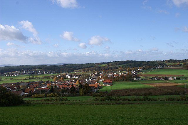
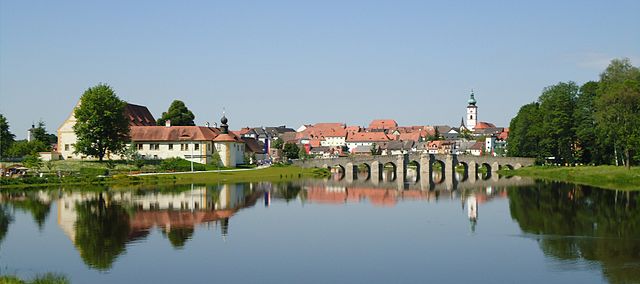
Neustadt an der Waldnaab
- municipality of Germany
Hiking in Neustadt an der Waldnaab
Neustadt an der Waldnaab is a charming town in Bavaria, Germany, surrounded by beautiful natural landscapes that are perfect for hiking enthusiasts. Here are some highlights and tips for hiking in this area:...
- Country:
- Postal Code: 92660
- Local Dialing Code: 09602
- Coordinates: 49° 43' 50" N, 12° 10' 14" E
- GPS tracks (wikiloc): [Link]
- AboveSeaLevel: 419 м m
- Area: 9.93 sq km
- Population: 5795
- Web site: [Link]

Waldthurn
- municipality of Germany
Hiking in Waldthurn
Waldthurn, nestled in the picturesque Bavarian region of Germany, offers beautiful landscapes and a variety of hiking opportunities. The area is characterized by lush forests, rolling hills, and scenic views, making it a perfect destination for nature enthusiasts and hikers of all skill levels....
- Country:
- Postal Code: 92727
- Local Dialing Code: 09657
- Licence Plate Code: NEW
- Coordinates: 49° 40' 17" N, 12° 19' 56" E
- GPS tracks (wikiloc): [Link]
- AboveSeaLevel: 556 м m
- Area: 30.94 sq km
- Population: 2072
- Web site: [Link]


Neustadt am Kulm
- municipality in Bavaria, Germany
Hiking in Neustadt am Kulm
Neustadt am Kulm is a charming town located in the Upper Franconia region of Bavaria, Germany. It is surrounded by scenic landscapes and offers plenty of opportunities for hikers of all levels. Here’s what you need to know about hiking in this area:...
- Country:
- Postal Code: 95514
- Local Dialing Code: 09648
- Licence Plate Code: NEW
- Coordinates: 49° 49' 0" N, 11° 49' 0" E
- GPS tracks (wikiloc): [Link]
- AboveSeaLevel: 517 м m
- Area: 20.30 sq km
- Population: 1126
- Web site: [Link]


Parkstein
- municipality of Germany
Hiking in Parkstein
Parkstein is a small, picturesque village located in Bavaria, Germany, and is known for its unique volcanic rock formations and lovely hiking trails. Hiking in Parkstein offers a great opportunity to explore both natural beauty and local culture. Here are some highlights for hiking in this area:...
- Country:
- Postal Code: 92711
- Local Dialing Code: 09602
- Licence Plate Code: NEW
- Coordinates: 49° 43' 0" N, 12° 4' 0" E
- GPS tracks (wikiloc): [Link]
- AboveSeaLevel: 547 м m
- Area: 30.84 sq km
- Population: 1749
- Web site: [Link]
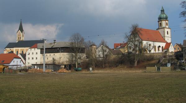

Mantel
- municipality of Germany
Hiking in Mantel
Hiking in Mantel, a picturesque region known for its stunning landscapes and diverse trails, can provide an unforgettable outdoor experience. While specific details about "Mantel" aren't directly available from my database, it’s essential to consider general aspects that can enhance your hiking experience in any picturesque area:...
- Country:
- Postal Code: 92708
- Local Dialing Code: 09605
- Coordinates: 49° 38' 0" N, 12° 3' 0" E
- GPS tracks (wikiloc): [Link]
- AboveSeaLevel: 400 м m
- Area: 16.84 sq km
- Population: 2773
- Web site: [Link]


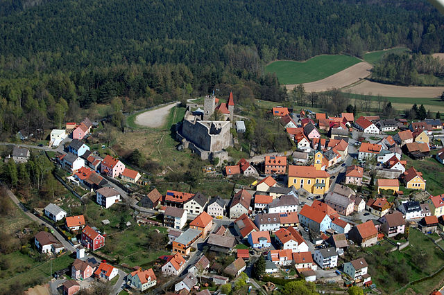
Flossenbürg
- municipality of Germany
Hiking in Flossenbürg
Flossenbürg is a picturesque village located in the Upper Palatinate region of Bavaria, Germany. It's surrounded by beautiful natural landscapes, making it a great destination for hiking enthusiasts. Here are some highlights of hiking in Flossenbürg:...
- Country:
- Postal Code: 92696
- Local Dialing Code: 09636; 09603
- Licence Plate Code: NEW
- Coordinates: 49° 44' 9" N, 12° 20' 55" E
- GPS tracks (wikiloc): [Link]
- AboveSeaLevel: 644 м m
- Area: 23.27 sq km
- Population: 1980
- Web site: [Link]


Windischeschenbach
- municipality of Germany
Hiking in Windischeschenbach
Windischeschenbach is a beautiful small town located in the Upper Franconia region of Bavaria, Germany. The area surrounding Windischeschenbach offers several appealing hiking opportunities, making it a great destination for outdoor enthusiasts....
- Country:
- Postal Code: 92670
- Local Dialing Code: 09681
- Licence Plate Code: NEW
- Coordinates: 49° 48' 0" N, 12° 10' 0" E
- GPS tracks (wikiloc): [Link]
- AboveSeaLevel: 438 м m
- Area: 36.37 sq km
- Population: 5014
- Web site: [Link]


Eschenbach in der Oberpfalz
- municipality of Germany
Hiking in Eschenbach in der Oberpfalz
Eschenbach in der Oberpfalz, located in Bavaria, Germany, offers a beautiful setting for hiking enthusiasts. The region is characterized by picturesque landscapes, rolling hills, and lush forests, making it ideal for various hiking trails....
- Country:
- Postal Code: 92676
- Local Dialing Code: 09645
- Licence Plate Code: NEW
- Coordinates: 49° 45' 0" N, 11° 49' 0" E
- GPS tracks (wikiloc): [Link]
- AboveSeaLevel: 440 м m
- Area: 35.13 sq km
- Population: 3948
- Web site: [Link]


Pressath
- municipality of Germany
Hiking in Pressath
Pressath is a small town in Bavaria, Germany, located in the district of Neustadt an der Waldnaab. It is surrounded by beautiful natural landscapes, making it a great destination for hiking enthusiasts. Here are some highlights and tips for hiking in and around Pressath:...
- Country:
- Postal Code: 92690
- Local Dialing Code: 09644
- Licence Plate Code: NEW
- Coordinates: 49° 46' 0" N, 11° 55' 0" E
- GPS tracks (wikiloc): [Link]
- AboveSeaLevel: 435 м m
- Area: 66.34 sq km
- Population: 4572
- Web site: [Link]

Vohenstrauß
- municipality of Germany
Hiking in Vohenstrauß
Vohenstrauß, located in Bavaria, Germany, is surrounded by beautiful natural landscapes, making it an excellent destination for hiking enthusiasts. The region is characterized by its rolling hills, dense forests, and scenic views, providing a variety of hiking trails suitable for different skill levels....
- Country:
- Postal Code: 92648
- Local Dialing Code: 09651
- Coordinates: 49° 37' 0" N, 12° 20' 0" E
- GPS tracks (wikiloc): [Link]
- AboveSeaLevel: 581 м m
- Area: 74.91 sq km
- Population: 7059
- Web site: [Link]


Pleystein
- municipality of Germany
Hiking in Pleystein
Pleystein is a charming town located in Bavaria, Germany, which offers a wealth of hiking opportunities in the surrounding landscape. The region is characterized by its beautiful mix of forests, hills, and valleys, making it an ideal destination for outdoor enthusiasts....
- Country:
- Postal Code: 92714
- Local Dialing Code: 09654
- Licence Plate Code: NEW
- Coordinates: 49° 39' 0" N, 12° 25' 0" E
- GPS tracks (wikiloc): [Link]
- AboveSeaLevel: 548 м m
- Area: 42.4 sq km
- Population: 2591
- Web site: [Link]


Kirchenthumbach
- municipality of Germany
Hiking in Kirchenthumbach
Kirchenthumbach is a picturesque village located in Bavaria, Germany, surrounded by beautiful landscapes ideal for hiking enthusiasts. The area is known for its diverse terrain, which includes rolling hills, dense forests, and meandering streams....
- Country:
- Postal Code: 91281
- Local Dialing Code: 09647
- Licence Plate Code: NEW
- Coordinates: 49° 45' 0" N, 11° 43' 0" E
- GPS tracks (wikiloc): [Link]
- AboveSeaLevel: 467 м m
- Area: 67.42 sq km
- Population: 3264
- Web site: [Link]

Pirk
- municipality of Germany
Hiking in Pirk
Pirk is a great spot for hiking, known for its beautiful trails and scenic landscapes. While specific trails may vary in difficulty, there are usually routes suitable for all levels, from beginner to experienced hikers....
- Country:
- Postal Code: 92712
- Local Dialing Code: 0961
- Licence Plate Code: NEW
- Coordinates: 49° 38' 0" N, 12° 10' 0" E
- GPS tracks (wikiloc): [Link]
- AboveSeaLevel: 397 м m
- Area: 26.17 sq km
- Population: 1629
- Web site: [Link]


Irchenrieth
- municipality of Germany
Hiking in Irchenrieth
Irchenrieth, a village located in Bavaria, Germany, is a lovely destination for hiking enthusiasts. Set in a picturesque landscape with rolling hills, forests, and fields, it offers several trails that cater to various skill levels. Here are some highlights and tips for hiking in Irchenrieth:...
- Country:
- Postal Code: 92699
- Local Dialing Code: 09659
- Licence Plate Code: NEW
- Coordinates: 49° 37' 0" N, 12° 14' 0" E
- GPS tracks (wikiloc): [Link]
- AboveSeaLevel: 425 м m
- Area: 5.27 sq km
- Population: 1574
- Web site: [Link]

Theisseil
- municipality of Germany
Hiking in Theisseil
Theisseil is a lesser-known hiking destination, and it may not be extensively documented like more popular hiking spots. However, if you are considering a hike in this area, I can offer some general advice on what to look for and how to enjoy your experience....
- Country:
- Postal Code: 92637
- Local Dialing Code: 0961; 09602
- Licence Plate Code: NEW
- Coordinates: 49° 42' 0" N, 12° 14' 0" E
- GPS tracks (wikiloc): [Link]
- AboveSeaLevel: 557 м m
- Area: 21.39 sq km
- Population: 985
- Web site: [Link]
Kirchendemenreuth
- municipality of Germany
Hiking in Kirchendemenreuth
Kirchendemenreuth is a small village located in Bavaria, Germany, known for its picturesque landscapes and proximity to nature. The area offers a variety of hiking opportunities that can cater to different skill levels and preferences. Here are some aspects to consider if you're planning a hiking trip in and around Kirchendemenreuth:...
- Country:
- Postal Code: 92665
- Local Dialing Code: 92665
- Licence Plate Code: NEW
- Coordinates: 49° 46' 0" N, 12° 5' 0" E
- GPS tracks (wikiloc): [Link]
- AboveSeaLevel: 579 м m
- Area: 39.32 sq km
- Population: 952
- Web site: [Link]


Störnstein
- municipality of Germany
Hiking in Störnstein
Störnstein is a charming town in Bavaria, Germany, known for its beautiful landscapes, lush forests, and rolling hills, providing an excellent backdrop for hiking enthusiasts. Here are some details about hiking in the area:...
- Country:
- Postal Code: 92721
- Local Dialing Code: 09602
- Licence Plate Code: NEW
- Coordinates: 49° 44' 0" N, 12° 13' 0" E
- GPS tracks (wikiloc): [Link]
- AboveSeaLevel: 449 м m
- Area: 10.91 sq km
- Population: 1181
- Web site: [Link]

Bechtsrieth
- municipality of Germany
Hiking in Bechtsrieth
Bechtsrieth, a small village in Bavaria, Germany, offers a serene hiking experience surrounded by the picturesque landscapes of the Upper Palatinate region. The area is characterized by rolling hills, lush forests, and beautiful meadows, making it ideal for both novice and experienced hikers....
- Country:
- Postal Code: 92699
- Local Dialing Code: 0961
- Licence Plate Code: NEW
- Coordinates: 49° 38' 48" N, 12° 12' 47" E
- GPS tracks (wikiloc): [Link]
- AboveSeaLevel: 452 м m
- Area: 4.79 sq km
- Population: 318
- Web site: [Link]

Leuchtenberg
- municipality of Germany
Hiking in Leuchtenberg
Leuchtenberg, located in Bavaria, Germany, is a charming area known for its beautiful landscapes and outdoor recreational opportunities, including hiking. The region offers a variety of hiking trails that cater to different skill levels, from easy walks to more challenging routes....
- Country:
- Postal Code: 92705
- Local Dialing Code: 09659
- Licence Plate Code: NEW
- Coordinates: 49° 36' 0" N, 12° 15' 0" E
- GPS tracks (wikiloc): [Link]
- AboveSeaLevel: 572 м m
- Area: 32.36 sq km
- Population: 1192
- Web site: [Link]


Püchersreuth
- municipality of Germany
Hiking in Püchersreuth
Püchersreuth is a charming municipality located in Bavaria, Germany, known for its picturesque landscapes and outdoor recreational opportunities, making it a wonderful spot for hiking enthusiasts. Here are some highlights you can expect when hiking in and around Püchersreuth:...
- Country:
- Postal Code: 92715
- Local Dialing Code: 09602
- Licence Plate Code: NEW
- Coordinates: 49° 45' 0" N, 12° 14' 0" E
- GPS tracks (wikiloc): [Link]
- AboveSeaLevel: 499 м m
- Area: 25.21 sq km
- Population: 1400
- Web site: [Link]


Trabitz
- municipality of Germany
Hiking in Trabitz
Trabitz is a charming area located in Germany, known for its scenic beauty and natural landscapes, making it a great destination for hiking enthusiasts. Here’s what you should know about hiking in Trabitz:...
- Country:
- Postal Code: 92724
- Local Dialing Code: 09644
- Licence Plate Code: NEW
- Coordinates: 49° 48' 6" N, 11° 53' 44" E
- GPS tracks (wikiloc): [Link]
- AboveSeaLevel: 455 м m
- Area: 26.68 sq km
- Population: 1289
- Web site: [Link]


Tännesberg
- municipality of Germany
Hiking in Tännesberg
Tännesberg is a lovely area located in Bavaria, Germany, known for its picturesque landscapes and outdoor activities, including hiking. The region offers various trails that cater to different skill levels, from easy walks to more challenging hikes, making it accessible for families and avid hikers alike....
- Country:
- Postal Code: 92723
- Local Dialing Code: 09655
- Licence Plate Code: NEW
- Coordinates: 49° 32' 0" N, 12° 20' 0" E
- GPS tracks (wikiloc): [Link]
- AboveSeaLevel: 585 м m
- Area: 46.56 sq km
- Population: 1579
- Web site: [Link]


Schlammersdorf
- municipality of Germany
Hiking in Schlammersdorf
Schlammersdorf, a small town in the Bavaria region of Germany, offers a variety of hiking opportunities that cater to both beginners and experienced hikers. The area is characterized by its picturesque landscapes, including rolling hills, wooded areas, and scenic views, making it a great destination for outdoor enthusiasts....
- Country:
- Postal Code: 95519
- Local Dialing Code: 09205
- Licence Plate Code: NEW
- Coordinates: 49° 47' 0" N, 11° 43' 0" E
- GPS tracks (wikiloc): [Link]
- AboveSeaLevel: 449 м m
- Area: 20.33 sq km
- Population: 775
- Web site: [Link]


Floß
- municipality of Germany
Hiking in Floß
Floß is a quaint village located in Bavaria, Germany, known for its picturesque landscapes and excellent hiking opportunities. The area features a mix of rolling hills, lush forests, and panoramic views, making it a great destination for both casual walkers and more experienced hikers....
- Country:
- Postal Code: 92685
- Local Dialing Code: 09603
- Licence Plate Code: NEW
- Coordinates: 49° 43' 0" N, 12° 16' 0" E
- GPS tracks (wikiloc): [Link]
- AboveSeaLevel: 487 м m
- Area: 54.39 sq km
- Population: 3609
- Web site: [Link]


Eslarn
- municipality of Germany
Hiking in Eslarn
Eslarn is a small town located in Bavaria, Germany, near the Czech border. It offers a beautiful natural landscape, making it an appealing destination for hiking enthusiasts. Here are some key points about hiking in Eslarn:...
- Country:
- Postal Code: 92693
- Local Dialing Code: 09653
- Licence Plate Code: NEW
- Coordinates: 49° 34' 57" N, 12° 31' 16" E
- GPS tracks (wikiloc): [Link]
- AboveSeaLevel: 516 м m
- Area: 55.22 sq km
- Population: 2997
- Web site: [Link]


Speinshart
- municipality of Germany
Hiking in Speinshart
Speinshart is a picturesque village located in Bavaria, Germany, surrounded by beautiful natural landscapes, making it an appealing destination for hiking enthusiasts. Here are some key points to consider when planning a hiking trip in and around Speinshart:...
- Country:
- Postal Code: 92676
- Local Dialing Code: 09645
- Licence Plate Code: NEW
- Coordinates: 49° 47' 13" N, 11° 49' 15" E
- GPS tracks (wikiloc): [Link]
- AboveSeaLevel: 425 м m
- Area: 23.76 sq km
- Population: 1138
- Web site: [Link]


Kohlberg
- municipality of Germany
Hiking in Kohlberg
Kohlberg, located in Bavaria, Germany, is a charming village that provides a great base for hiking enthusiasts. The surrounding landscape features rolling hills, dense forests, and scenic views, making it an excellent choice for both casual walkers and serious hikers. Here are some highlights about hiking in the area:...
- Country:
- Postal Code: 92702
- Local Dialing Code: 09608
- Licence Plate Code: NEW
- Coordinates: 49° 36' 0" N, 12° 1' 0" E
- GPS tracks (wikiloc): [Link]
- AboveSeaLevel: 482 м m
- Area: 33.52 sq km
- Population: 1175
- Web site: [Link]

Luhe-Wildenau
- municipality of Germany
Hiking in Luhe-Wildenau
Luhe-Wildenau is a picturesque municipality located in Bavaria, Germany, known for its beautiful landscapes and outdoor recreational opportunities, including hiking. The region is characterized by rolling hills, forests, and scenic trails that provide a wonderful backdrop for hikers of all experience levels....
- Country:
- Postal Code: 92706
- Local Dialing Code: 09607
- Licence Plate Code: NEW
- Coordinates: 49° 35' 2" N, 12° 9' 4" E
- GPS tracks (wikiloc): [Link]
- AboveSeaLevel: 389 м m
- Area: 38.67 sq km
- Population: 3400
- Web site: [Link]
Schwarzenbach
- municipality of Germany
Hiking in Schwarzenbach
Schwarzenbach, located in the Upper Palatinate region of Bavaria, Germany, is a wonderful destination for hiking enthusiasts. This area is characterized by picturesque landscapes featuring rolling hills, dense forests, and charming villages. Here are some highlights and tips for hiking in Schwarzenbach:...
- Country:
- Postal Code: 92720
- Local Dialing Code: 09644
- Licence Plate Code: NEW
- Coordinates: 49° 44' 0" N, 12° 0' 0" E
- GPS tracks (wikiloc): [Link]
- AboveSeaLevel: 414 м m
- Area: 11.91 sq km
- Population: 819
- Web site: [Link]


Moosbach
- municipality of Germany
Hiking in Moosbach
Moosbach, a quaint municipality in the Bavarian region of Germany, offers picturesque hiking opportunities surrounded by stunning landscapes. Here are some highlights for hiking in and around Moosbach:...
- Country:
- Postal Code: 92709
- Local Dialing Code: 09656
- Licence Plate Code: NEW
- Coordinates: 49° 36' 0" N, 12° 25' 0" E
- GPS tracks (wikiloc): [Link]
- AboveSeaLevel: 499 м m
- Area: 64.31 sq km
- Population: 2639
- Web site: [Link]


Weiherhammer
- municipality of Germany
Hiking in Weiherhammer
Weiherhammer is a charming locality in Bavaria, Germany, known for its picturesque landscapes and outdoor recreational opportunities. Although it may not be as famous as other hiking destinations in the region, it offers a delightful experience for those looking to explore nature on foot. Here are some aspects to consider when hiking in and around Weiherhammer:...
- Country:
- Postal Code: 92729
- Local Dialing Code: 09605
- Licence Plate Code: NEW
- Coordinates: 49° 38' 0" N, 12° 4' 0" E
- GPS tracks (wikiloc): [Link]
- AboveSeaLevel: 394 м m
- Area: 39.92 sq km
- Population: 3655
- Web site: [Link]


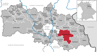
Georgenberg
- municipality of Germany
Hiking in Georgenberg
Georgenberg, located in Neustadt, Germany, is an attractive destination for hikers due to its scenic landscapes, diverse trails, and rich natural beauty. The area features a mix of forests, hills, and valleys, making it suitable for various levels of hiking expertise, from beginners to more experienced trekkers....
- Country:
- Postal Code: 92697
- Local Dialing Code: 09658
- Licence Plate Code: NEW
- Coordinates: 49° 42' 0" N, 12° 25' 0" E
- GPS tracks (wikiloc): [Link]
- AboveSeaLevel: 600 м m
- Area: 36.81 sq km
- Population: 1508
- Web site: [Link]


Waidhaus
- municipality of Germany
Hiking in Waidhaus
Waidhaus is a charming town located in Bavaria, Germany, near the border with the Czech Republic. It's a great starting point for hiking enthusiasts who want to explore the surrounding natural beauty. Here are some highlights about hiking in and around Waidhaus:...
- Country:
- Postal Code: 92726
- Local Dialing Code: 09652
- Licence Plate Code: NEW
- Coordinates: 49° 38' 30" N, 12° 29' 40" E
- GPS tracks (wikiloc): [Link]
- AboveSeaLevel: 524 м m
- Area: 37.32 sq km
- Population: 2413
- Web site: [Link]
Vorbach
- municipality of Germany
Hiking in Vorbach
Vorbach is a picturesque village located in the beautiful region of Bavaria, Germany. It's surrounded by stunning natural landscapes, making it a great spot for hiking enthusiasts. Here are some aspects to consider if you're planning a hiking trip in and around Vorbach:...
- Country:
- Postal Code: 95519
- Local Dialing Code: 09205
- Licence Plate Code: NEW
- Coordinates: 49° 49' 0" N, 11° 45' 0" E
- GPS tracks (wikiloc): [Link]
- AboveSeaLevel: 445 м m
- Area: 13.54 sq km
- Population: 908
- Web site: [Link]


Speinsharter Forst
- unincorporated area in Germany
Hiking in Speinsharter Forst
Speinsharter Forst, located in Bavaria, Germany, is a beautiful area known for its lush forests and diverse landscapes, making it a fantastic destination for hiking enthusiasts. Here are some key points about hiking in Speinsharter Forst:...
- Country:
- Coordinates: 49° 48' 0" N, 11° 48' 0" E
- GPS tracks (wikiloc): [Link]
Shares border with regions:
Tirschenreuth
- district of Bavaria, Germany
Hiking in Tirschenreuth
Tirschenreuth is a district in Bavaria, Germany, known for its picturesque landscapes, forests, and numerous hiking trails. If you're planning to hike in this district, here's what you need to know:...
- Country:
- Capital: Tirschenreuth
- Licence Plate Code: TIR; KEM
- Coordinates: 49° 54' 0" N, 12° 12' 0" E
- GPS tracks (wikiloc): [Link]
- AboveSeaLevel: 499 м m
- Area: 1085.08 sq km
- Population: 77865
- Web site: [Link]
Amberg-Sulzbach
- district of Bavaria, Germany
Hiking in Amberg-Sulzbach
Amberg-Sulzbach, located in Bavaria, Germany, is a picturesque district known for its beautiful landscapes, rich culture, and numerous outdoor activities, including hiking. The area offers a variety of hiking trails that cater to different skill levels, from easy walks suitable for families to more challenging paths for experienced hikers....
- Country:
- Capital: Amberg
- Licence Plate Code: SUL; NAB; ESB; BUL; AS
- Coordinates: 49° 30' 0" N, 11° 45' 0" E
- GPS tracks (wikiloc): [Link]
- AboveSeaLevel: 380 м m
- Area: 1255.00 sq km
- Population: 94617
- Web site: [Link]

Schwandorf
- district of Bavaria, Germany
Hiking in Schwandorf
Schwandorf district, located in Bavaria, Germany, is a great area for hiking enthusiasts looking for scenic routes and beautiful landscapes. The region is characterized by rolling hills, forests, and rivers, providing a mix of terrain that caters to various hiking levels....
- Country:
- Capital: Schwandorf
- Licence Plate Code: SAD; ROD; OVI; NEN; NAB; BUL
- Coordinates: 49° 22' 12" N, 12° 15' 0" E
- GPS tracks (wikiloc): [Link]
- AboveSeaLevel: 465 м m
- Area: 1472.88 sq km
- Population: 131260
- Web site: [Link]

Bayreuth
- district in Bavaria, Germany
Hiking in Bayreuth
Bayreuth, located in the northern part of Bavaria, Germany, offers a diverse range of hiking opportunities set against a backdrop of beautiful landscapes, forests, and cultural sites. The region is known for its rich history, stunning scenery, and well-marked trails suitable for hikers of all levels....
- Country:
- Capital: Bayreuth
- Licence Plate Code: PEG; MÜB; KEM; ESB; EBS; BT
- Coordinates: 49° 55' 12" N, 11° 30' 0" E
- GPS tracks (wikiloc): [Link]
- AboveSeaLevel: 507 м m
- Area: 1273.00 sq km
- Population: 96772
- Web site: [Link]

Weiden in der Oberpfalz
- town in Bavaria, Germany
Hiking in Weiden in der Oberpfalz
Weiden in der Oberpfalz, located in Bavaria, Germany, is surrounded by beautiful landscapes that offer a variety of hiking opportunities. The region's natural beauty includes forests, hills, valleys, and rivers, making it a great destination for outdoor enthusiasts....
- Country:
- Postal Code: 92637
- Local Dialing Code: 0961
- Licence Plate Code: WEN
- Coordinates: 49° 40' 0" N, 12° 9' 0" E
- GPS tracks (wikiloc): [Link]
- AboveSeaLevel: 397 м m
- Area: 70.57 sq km
- Population: 42543
- Web site: [Link]