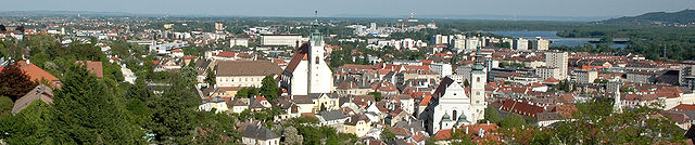
Traismauer (Traismauer)
- municipality in Austria
 Hiking in Traismauer
Traismauer is a charming town in Lower Austria that offers a variety of hiking opportunities, especially for those looking to explore the scenic beauty of the region. Here are some highlights for hiking in and around Traismauer:
Scenic Trails
-
Local Trails: Traismauer is surrounded by lush forests, rolling hills, and vineyards. There are numerous marked hiking trails that cater to various skill levels, allowing hikers to enjoy the natural beauty and tranquility of the area.
-
Nature Reserves: The nearby nature reserves provide opportunities to spot local wildlife and enjoy diverse plant life. These areas are often well-marked and offer peaceful trails.
-
Wine Trails: Given the region's wine production, some trails may lead you through vineyards, allowing for a combination of hiking and local wine tasting experiences.
Historical and Cultural Sites
While hiking, you may come across historical sites, such as old churches, castles, and rural architecture that add cultural context to your journey.
Facilities
- Signage: Most trails are well-marked with signs indicating distances and trail difficulty.
- Picnic Areas: Many trails feature picnic spots where hikers can take a break and enjoy the scenery.
Tips for Hiking in Traismauer
- Weather: Always check the weather before heading out, as conditions can change rapidly.
- Proper Gear: Wear appropriate hiking boots and clothing suited for the terrain and weather.
- Stay Hydrated: Bring enough water and snacks, especially if you're planning a longer hike.
- Trail Maps: Consider bringing a map or using a hiking app to navigate the trails.
Overall, hiking in Traismauer can be a fulfilling experience, with the chance to appreciate both nature and local culture. Whether you're looking for a leisurely walk or a more challenging hike, there's something for everyone in this picturesque area of Lower Austria.
- Country:

- Postal Code: 3133
- Licence Plate Code: PL
- Coordinates: 48° 20' 0" N, 15° 43' 59" E


- GPS tracks (wikiloc): [Link]
- AboveSeaLevel: 197 м m
- Area: 43.14 sq km
- Population: 6224
- Web site: http://www.traismauer.at/
- Wikipedia en: wiki(en)
- Wikipedia: wiki(de)
- Wikidata storage: Wikidata: Q305159
- Wikipedia Commons Category: [Link]
- Freebase ID: [/m/03grrv7]
- GeoNames ID: Alt: [2763459]
- BnF ID: [11948331q]
- VIAF ID: Alt: [149653821]
- GND ID: Alt: [4060599-1]
- archINFORM location ID: [15787]
- Library of Congress authority ID: Alt: [n94116665]
- MusicBrainz area ID: [3514b315-1300-4f3e-b532-b2902c37f33a]
- Austrian municipality key: [31943]
Shares border with regions:
Krems an der Donau
- city in Austria
Hiking in Krems an der Donau
Krems an der Donau is a picturesque town in Lower Austria, situated at the confluence of the Danube River and the Krems River. It is surrounded by beautiful landscapes, vineyards, and the scenic rolling hills of the Wachau Valley, making it a great destination for hiking enthusiasts. Here are some highlights and tips for hiking in and around Krems an der Donau:...
- Country:
- Postal Code: 3500
- Licence Plate Code: KS
- Coordinates: 48° 25' 0" N, 15° 37' 0" E
- GPS tracks (wikiloc): [Link]
- AboveSeaLevel: 203 м m
- Area: 51.61 sq km
- Population: 24610
- Web site: [Link]

Zwentendorf an der Donau
- municipality in Austria
Hiking in Zwentendorf an der Donau
Zwentendorf is a small town in Austria, located in the state of Lower Austria, near the Danube River. While it may not be as prominent as some other hiking destinations in the region, it offers some pleasant opportunities for walking and exploring the natural landscapes....
- Country:
- Postal Code: 3435
- Local Dialing Code: 02277
- Licence Plate Code: TU
- Coordinates: 48° 20' 33" N, 15° 54' 50" E
- GPS tracks (wikiloc): [Link]
- AboveSeaLevel: 182 м m
- Area: 53.9 sq km
- Population: 3982
- Web site: [Link]
Nußdorf ob der Traisen
- municipality in Austria
Hiking in Nußdorf ob der Traisen
Nußdorf ob der Traisen is a charming village located in the Lower Austria region of Austria, surrounded by picturesque landscapes that are perfect for hiking enthusiasts. The area offers a variety of hiking trails that cater to different skill levels, making it a wonderful destination for both novice and experienced hikers....
- Country:
- Postal Code: 3134
- Local Dialing Code: 02783
- Licence Plate Code: PL
- Coordinates: 48° 21' 12" N, 15° 41' 42" E
- GPS tracks (wikiloc): [Link]
- AboveSeaLevel: 249 м m
- Area: 15.43 sq km
- Population: 1758
- Web site: [Link]

Gedersdorf
- municipality in Austria
Hiking in Gedersdorf
Gedersdorf is located in the beautiful region of Lower Austria, not far from the city of Krems and the picturesque Wachau Valley. This area is known for its scenic landscapes, including vineyards, rolling hills, and charming villages, making it a wonderful destination for hiking enthusiasts....
- Country:
- Postal Code: 3494
- Local Dialing Code: 02735
- Licence Plate Code: KR
- Coordinates: 48° 26' 1" N, 15° 41' 14" E
- GPS tracks (wikiloc): [Link]
- AboveSeaLevel: 194 м m
- Area: 18.87 sq km
- Population: 2184
- Web site: [Link]

Herzogenburg
- municipality in Austria
Hiking in Herzogenburg
Herzogenburg, located in the Lower Austria region, is a charming town that offers several opportunities for hiking and enjoying the natural beauty of the surrounding areas. Here are some key features and recommendations for hiking in and around Herzogenburg:...
- Country:
- Postal Code: 3130
- Local Dialing Code: 02782
- Licence Plate Code: PL
- Coordinates: 48° 17' 0" N, 15° 41' 0" E
- GPS tracks (wikiloc): [Link]
- AboveSeaLevel: 229 м m
- Area: 46.16 sq km
- Population: 7771
- Web site: [Link]

Grafenwörth
- municipality in Austria
Hiking in Grafenwörth
Grafenwörth, located in Austria, is a charming destination for hiking enthusiasts. Nestled along the banks of the Danube River and surrounded by beautiful landscapes, it offers several trails that cater to various skill levels. Here are some key points about hiking in Grafenwörth:...
- Country:
- Postal Code: 3484
- Local Dialing Code: 02738
- Licence Plate Code: TU
- Coordinates: 48° 24' 24" N, 15° 46' 43" E
- GPS tracks (wikiloc): [Link]
- AboveSeaLevel: 190 м m
- Area: 46.4 sq km
- Population: 3132
- Web site: [Link]

Sitzenberg-Reidling
- municipality in Austria
Hiking in Sitzenberg-Reidling
Sitzenberg-Reidling, located in Lower Austria, offers a variety of scenic hiking opportunities for outdoor enthusiasts. The region is characterized by its rolling hills, vineyards, and charming villages, making it an ideal destination for both casual walkers and seasoned hikers. Here are some highlights and tips for hiking in this area:...
- Country:
- Postal Code: 3454
- Local Dialing Code: 02276
- Licence Plate Code: TU
- Coordinates: 48° 19' 12" N, 15° 48' 48" E
- GPS tracks (wikiloc): [Link]
- AboveSeaLevel: 205 м m
- Area: 22.15 sq km
- Population: 2102
- Web site: [Link]