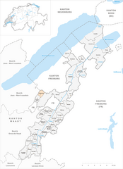
Treytorrens (Treytorrens)
- municipality in Switzerland
Treytorrens, while not a widely recognized hiking destination in popular literature, might refer to a less-known region or a specific local area. If you are seeking hiking information in that location, here are some general guidelines and considerations that can enhance your hiking experience:
-
Research Local Trails: Look for established hiking trails in Treytorrens. Local hiking clubs or organizations often provide detailed maps and information online, including trail difficulty levels, distances, and estimated hiking times.
-
Terrain and Elevation: Understand the terrain you will be hiking. Is it mountainous, flat, or hilly? Look into elevation changes, as steeper trails can be more challenging and may require more physical endurance.
-
Weather Conditions: Always check the weather forecast before heading out. Conditions can change rapidly, especially in mountainous or coastal areas. Dress in layers and prepare for both warm and cool weather conditions.
-
Safety Precautions: Let someone know your hiking plans and expected return time. Carry a first aid kit, plenty of water, and snacks. It’s also advisable to have a map and compass, or a reliable GPS device.
-
Leave No Trace: Follow the Leave No Trace principles to minimize your impact on the environment. Pack out what you pack in, stay on designated trails, and respect wildlife and plants.
-
Local Wildlife: Be aware of the local wildlife and what to do if you encounter animals. Familiarize yourself with the types of animals you might see and any safety tips related to them.
-
Community Resources: Check for local resources such as visitor centers, which often have maps and personal insights about the trails and current conditions.
If Treytorrens is a specific area within a country or region, I recommend providing a bit more context, and I can offer more tailored advice! Happy hiking!
- Country:

- Postal Code: 1538
- Local Dialing Code: 026
- Licence Plate Code: VD
- Coordinates: 46° 46' 0" N, 6° 48' 0" E


- GPS tracks (wikiloc): [Link]
- AboveSeaLevel: 661 м m
- Area: 3.07 sq km
- Population: 122
- Web site: http://www.treytorrens.ch
- Wikipedia en: wiki(en)
- Wikipedia: wiki(de)
- Wikidata storage: Wikidata: Q70673
- Wikipedia Commons Category: [Link]
- Freebase ID: [/m/05rphs]
- GeoNames ID: Alt: [7287329]
- OSM relation ID: [1685167]
- HDS ID: [2590]
- Swiss municipality code: [5828]

