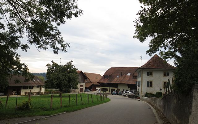
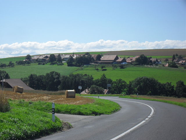
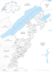
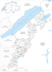
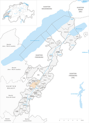
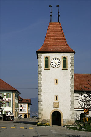
Broye-Vully District (Bezirk Broye-Vully)

- district of the canton of Vaud, Switzerland
 Hiking in Broye-Vully District
The Broye-Vully District, located in the canton of Vaud in Switzerland, is a fantastic destination for hiking enthusiasts. This region offers a variety of trails suitable for different skill levels, catering to both casual walkers and more experienced hikers.
Key Highlights of Hiking in Broye-Vully:
-
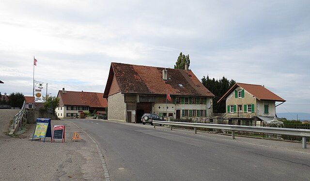
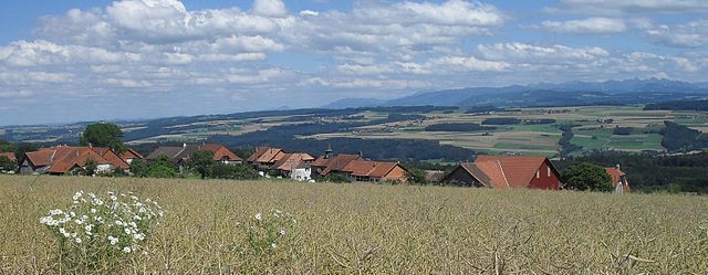
Scenic Landscapes: The district is characterized by beautiful rolling hills, vineyards, and stunning views of Lake Murten and Lake Neuchâtel. The scenery varies from pastoral landscapes to wooded areas, offering a diverse hiking experience.
-
Wine Trails: The area is known for its vineyards, particularly the Vully wine region. Hiking through the vineyards provides an excellent opportunity to enjoy the scenic beauty while sampling local wines at vineyards along the way.
-
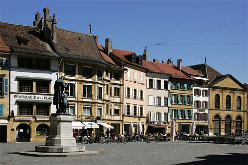
Historical Sites: As you hike, you may encounter various historical sites, including ancient castles and charming villages. The town of Murten, with its well-preserved medieval architecture and beautiful lakeside promenade, is a must-visit.
-
Trail Variety: There are various marked hiking trails, ranging from easy walks suitable for families to more challenging hikes for seasoned trekkers. The terrain can vary, so be prepared for both flat paths and more ascendant routes.
-
Nature Reserves: The district also features several natural reserves where hikers can observe local wildlife and enjoy tranquility away from urban areas.
-
Accessibility: The region is easily accessible by public transport, making it convenient for day hikes or weekend getaways from larger cities in Switzerland.
Tips for Hiking in Broye-Vully:
- Seasonal Considerations: Spring and autumn are ideal for hiking, as temperatures are moderate and the scenery is particularly beautiful during these times.
- Equipment: Wear appropriate hiking shoes and bring a water bottle, snacks, and a map or a GPS device to keep track of your route.
- Local Guidance: Consider joining a guided hike or local hiking group if you're unfamiliar with the area; they can provide insights on the best trails and hidden gems.
Overall, the Broye-Vully District offers an enchanting blend of natural beauty, rich history, and enjoyable hiking experiences. Whether you're looking for a leisurely stroll or a vigorous hike, this region has something to offer everyone. Enjoy your adventure!
- Country:

- Capital: Payerne
- Licence Plate Code: VD
- Coordinates: 46° 49' 0" N, 6° 56' 0" E


- GPS tracks (wikiloc): [Link]
- AboveSeaLevel: 471 м m
- Area: 264.98 sq km
- Wikipedia en: wiki(en)
- Wikipedia: wiki(de)
- Wikidata storage: Wikidata: Q495882
- Wikipedia Commons Category: [Link]
- Freebase ID: [/m/04f4xjf]
- GeoNames ID: Alt: [7285002]
- archINFORM location ID: [42802]
Includes regions:


Avenches
- municipality in Switzerland
Hiking in Avenches
Avenches, located in the canton of Vaud in Switzerland, is a beautiful area rich in history and natural beauty, making it a great destination for hiking. Here are some highlights regarding hiking in and around Avenches:...
- Country:
- Local Dialing Code: 026
- Licence Plate Code: VD
- Coordinates: 46° 52' 48" N, 7° 2' 23" E
- GPS tracks (wikiloc): [Link]
- AboveSeaLevel: 435 м m
- Area: 19.46 sq km
- Population: 4208
- Web site: [Link]


Brenles
- municipality in Switzerland
Hiking in Brenles
Brenles, known for its beautiful landscapes and serene natural environment, offers a variety of hiking opportunities for all levels. While it's a smaller area that may not be as widely known as famous hiking regions, it provides unique trails that showcase the local flora and fauna....
- Country:
- Local Dialing Code: 021
- Licence Plate Code: VD
- Coordinates: 46° 40' 0" N, 6° 51' 0" E
- GPS tracks (wikiloc): [Link]
- AboveSeaLevel: 765 м m
- Area: 3.85 sq km
- Web site: [Link]

Bussy-sur-Moudon
- municipality in Switzerland
Hiking in Bussy-sur-Moudon
Bussy-sur-Moudon is a charming village located in the Vaud canton of Switzerland, surrounded by lush landscapes, rolling hills, and beautiful natural scenery. Hiking in this area offers a variety of trails that cater to different skill levels and provide spectacular views of the Swiss countryside....
- Country:
- Local Dialing Code: 021
- Licence Plate Code: VD
- Coordinates: 46° 41' 0" N, 6° 49' 0" E
- GPS tracks (wikiloc): [Link]
- AboveSeaLevel: 628 м m
- Area: 3.09 sq km
- Population: 208


Forel-sur-Lucens
- municipality in the canton of Vaud, Switzerland
Hiking in Forel-sur-Lucens
Forel-sur-Lucens is a picturesque village located in the canton of Vaud, Switzerland. It offers various hiking opportunities that cater to different skill levels, from leisurely walks to more challenging treks. Here’s a general overview of what you can expect when hiking in and around Forel-sur-Lucens:...
- Country:
- Postal Code: 1526
- Local Dialing Code: 021
- Licence Plate Code: VD
- Coordinates: 46° 44' 0" N, 6° 49' 0" E
- GPS tracks (wikiloc): [Link]
- AboveSeaLevel: 672 м m
- Area: 2.84 sq km
- Population: 153


Carrouge
- municipality in the canton de Vaud, Switzerland
Hiking in Carrouge
Carrouge is located in the Canton of Vaud, Switzerland, and while it may not be as widely known for hiking as some surrounding areas, it offers various opportunities to enjoy nature and scenic landscapes. Here are some insights to help you explore hiking in and around Carrouge:...
- Country:
- Local Dialing Code: 021
- Licence Plate Code: VD
- Coordinates: 46° 36' 0" N, 6° 46' 0" E
- GPS tracks (wikiloc): [Link]
- AboveSeaLevel: 728 м m
- Area: 5.43 sq km
- Web site: [Link]

Champtauroz
- municipality in Switzerland
Hiking in Champtauroz
Champtauroz is a charming village located in the Vaud region of Switzerland, nestled in the Swiss Pre-Alps. The area is not only known for its picturesque landscapes but also for a variety of hiking opportunities that cater to different skill levels. Here are some highlights of hiking in and around Champtauroz:...
- Country:
- Local Dialing Code: 026
- Licence Plate Code: VD
- Coordinates: 46° 46' 0" N, 6° 47' 0" E
- GPS tracks (wikiloc): [Link]
- AboveSeaLevel: 692 м m
- Area: 3.05 sq km
- Population: 128


Chavannes-sur-Moudon
- municipality in Switzerland
Hiking in Chavannes-sur-Moudon
Chavannes-sur-Moudon is a picturesque village in the Vaud region of Switzerland, known for its beautiful landscapes and great opportunities for hiking. The area offers a mix of easy walks and more challenging hikes, making it suitable for hikers of all levels....
- Country:
- Local Dialing Code: 021
- Licence Plate Code: VD
- Coordinates: 46° 39' 0" N, 6° 48' 0" E
- GPS tracks (wikiloc): [Link]
- AboveSeaLevel: 680 м m
- Area: 5.15 sq km
- Population: 220
- Web site: [Link]


Chesalles-sur-Moudon
- municipality in Switzerland
Hiking in Chesalles-sur-Moudon
Chesalles-sur-Moudon is a charming village located in the Vaud region of Switzerland, surrounded by picturesque landscapes and rolling hills, making it an excellent destination for hiking enthusiasts. Here are some things to consider when planning a hike in this area:...
- Country:
- Local Dialing Code: 021
- Licence Plate Code: VD
- Coordinates: 46° 41' 0" N, 6° 50' 0" E
- GPS tracks (wikiloc): [Link]
- AboveSeaLevel: 702 м m
- Area: 1.65 sq km
- Web site: [Link]

Chevroux
- municipality in Switzerland
Hiking in Chevroux
Chevroux is a charming small village located in the Swiss canton of Vaud, nestled near the shores of Lake Geneva and surrounded by beautiful landscapes. While it might not be a widely recognized hiking hotspot, the region offers numerous trails and routes that showcase Switzerland's stunning natural beauty....
- Country:
- Local Dialing Code: 026
- Licence Plate Code: VD
- Coordinates: 46° 53' 0" N, 6° 54' 0" E
- GPS tracks (wikiloc): [Link]
- AboveSeaLevel: 454 м m
- Area: 4.37 sq km
- Population: 469
- Web site: [Link]


Corcelles-le-Jorat
- municipality in Switzerland
Hiking in Corcelles-le-Jorat
Corcelles-le-Jorat is a picturesque village located in the Vaud region of Switzerland, surrounded by beautiful landscapes and forests that are ideal for hiking enthusiasts. The area offers a variety of trails that cater to different skill levels, from novice walkers to experienced hikers....
- Country:
- Local Dialing Code: 021
- Licence Plate Code: VD
- Coordinates: 46° 36' 0" N, 6° 45' 0" E
- GPS tracks (wikiloc): [Link]
- AboveSeaLevel: 786 м m
- Area: 7.94 sq km
- Population: 458
- Web site: [Link]


Corcelles-près-Payerne
- municipality in Switzerland
Hiking in Corcelles-près-Payerne
Corcelles-près-Payerne is a charming village located in the Canton of Fribourg, Switzerland. The area offers a variety of hiking opportunities that showcase the beautiful Swiss countryside. Here are some key points to consider if you're planning a hiking trip in this region:...
- Country:
- Postal Code: 1562
- Local Dialing Code: 026
- Licence Plate Code: VD
- Coordinates: 46° 49' 9" N, 6° 56' 5" E
- GPS tracks (wikiloc): [Link]
- AboveSeaLevel: 447 м m
- Area: 12.19 sq km
- Population: 2443
- Web site: [Link]


Cremin
- municipality in Switzerland
Hiking in Cremin
Cremin is a beautiful destination for hiking, though it seems you may be referring to a specific area that could vary by country. There isn't an internationally recognized location named "Cremin" that's widely known for hiking. However, if you meant a region or mountain area like Cremin in France or a trail with a similar name, would you please specify the exact location, or clarify if it's near a city or specific park?...
- Country:
- Postal Code: 1526
- Local Dialing Code: 021
- Licence Plate Code: VD
- Coordinates: 46° 43' 0" N, 6° 50' 0" E
- GPS tracks (wikiloc): [Link]
- AboveSeaLevel: 639 м m
- Area: 1.63 sq km


Vulliens
- municipality in Switzerland
Hiking in Vulliens
Vulliens is a small municipality located in the Canton of Vaud in Switzerland, known for its beautiful natural landscapes. While it may not be as famous as other hiking regions in Switzerland, it offers a peaceful environment with various trails that provide a glimpse of the Swiss countryside....
- Country:
- Postal Code: 1085
- Local Dialing Code: 021
- Licence Plate Code: VD
- Coordinates: 46° 37' 0" N, 6° 48' 0" E
- GPS tracks (wikiloc): [Link]
- AboveSeaLevel: 708 м m
- Area: 6.64 sq km
- Population: 516
- Web site: [Link]


Sarzens
- municipality in Switzerland
Hiking in Sarzens
Sarzens, a beautiful region in the heart of nature, offers a variety of hiking options for outdoor enthusiasts. While I don't have specific details about a location named Sarzens, here's a general guide to what you might expect when hiking in a region characterized by picturesque landscapes, lush forests, and diverse wildlife....
- Country:
- Postal Code: 1683
- Local Dialing Code: 021
- Licence Plate Code: VD
- Coordinates: 46° 41' 0" N, 6° 51' 0" E
- GPS tracks (wikiloc): [Link]
- AboveSeaLevel: 719 м m
- Area: 1.45 sq km


Syens
- municipality in Switzerland
Hiking in Syens
It seems there might be a typographical error in your request, as "Syens" does not correspond to a known hiking destination or area. If you meant "Sierra," "Seychells," "Sierra Nevada," or another specific hiking location, please clarify, and I'd be glad to provide you with information on hiking in that area....
- Country:
- Postal Code: 1510
- Local Dialing Code: 021
- Licence Plate Code: VD
- Coordinates: 46° 39' 0" N, 6° 47' 0" E
- GPS tracks (wikiloc): [Link]
- AboveSeaLevel: 588 м m
- Area: 2.53 sq km
- Population: 149
- Web site: [Link]


Curtilles
- municipality in Switzerland
Hiking in Curtilles
Curtilles is a picturesque area often celebrated for its scenic hikes, beautiful landscapes, and varied trails suitable for different levels of hikers. Here’s a general overview of what to expect when hiking in Curtilles, although specifics may vary depending on the exact location:...
- Country:
- Postal Code: 1521
- Local Dialing Code: 021
- Licence Plate Code: VD
- Coordinates: 46° 42' 0" N, 6° 51' 0" E
- GPS tracks (wikiloc): [Link]
- AboveSeaLevel: 516 м m
- Area: 4.49 sq km
- Population: 318
- Web site: [Link]


Lovatens
- municipality in Switzerland
Hiking in Lovatens
It seems like there might be a small confusion with the name "Lovatens." As of my last update in October 2023, there isn't a widely recognized hiking destination by that specific name. However, if you're referring to a specific location or region that might be lesser-known or spelled differently, please provide more context or check the name....
- Country:
- Postal Code: 1682
- Local Dialing Code: 021
- Licence Plate Code: VD
- Coordinates: 46° 41' 0" N, 6° 52' 0" E
- GPS tracks (wikiloc): [Link]
- AboveSeaLevel: 712 м m
- Area: 3.45 sq km
- Population: 141
- Web site: [Link]


Rossenges
- municipality in Switzerland
Hiking in Rossenges
Hiking in Rossenges, a picturesque village in the Vaud region of Switzerland, offers stunning landscapes and various trails for hikers of all levels. The surrounding areas feature lush green hills, rolling vineyards, and views of nearby mountains, creating a perfect backdrop for outdoor enthusiasts....
- Country:
- Postal Code: 1513
- Local Dialing Code: 021
- Licence Plate Code: VD
- Coordinates: 46° 39' 0" N, 6° 47' 0" E
- GPS tracks (wikiloc): [Link]
- AboveSeaLevel: 662 м m
- Area: 1.08 sq km
- Population: 62


Hermenches
- municipality in Switzerland
Hiking in Hermenches
It seems there might be a typographical error or misunderstanding regarding "Hermenches," as it does not appear to correspond to a known hiking location. If you meant "Hermitage," "Hermon," or another specific hiking area, please clarify, and I'd be happy to provide relevant information....
- Country:
- Postal Code: 1513
- Local Dialing Code: 021
- Licence Plate Code: VD
- Coordinates: 46° 38' 0" N, 6° 46' 0" E
- GPS tracks (wikiloc): [Link]
- AboveSeaLevel: 679 м m
- Area: 4.56 sq km
- Population: 379
- Web site: [Link]


Henniez
- municipality in Switzerland
Hiking in Henniez
Henniez, located in the canton of Vaud in Switzerland, is a beautiful area known for its natural landscapes, impressive views, and serene hiking trails. Here are some key points to consider for hiking in Henniez:...
- Country:
- Postal Code: 1525
- Local Dialing Code: 026
- Licence Plate Code: VD
- Coordinates: 46° 45' 0" N, 6° 53' 0" E
- GPS tracks (wikiloc): [Link]
- AboveSeaLevel: 484 м m
- Area: 2.63 sq km
- Population: 359
- Web site: [Link]


Trey
- municipality in Switzerland
Hiking in Trey
Trey, Switzerland, is not a well-known hiking destination, but it could be a reference to the broader region surrounding the picturesque landscapes of Switzerland, which offers a plethora of hiking opportunities. If you're looking for hiking experiences in Switzerland, I can guide you through some fantastic options nearby....
- Country:
- Postal Code: 1552
- Local Dialing Code: 026
- Licence Plate Code: VD
- Coordinates: 46° 46' 0" N, 6° 55' 0" E
- GPS tracks (wikiloc): [Link]
- AboveSeaLevel: 576 м m
- Area: 3.80 sq km
- Population: 270
- Web site: [Link]

Dompierre
- municipality in the canton of Vaud, Switzerland
Hiking in Dompierre
Dompierre is a charming village located in the Vaud region of Switzerland, surrounded by beautiful landscapes ideal for hiking. The area offers a mix of leisurely walks and more challenging hikes, catering to various skill levels....
- Country:
- Postal Code: 1582
- Local Dialing Code: 026
- Licence Plate Code: VD
- Coordinates: 46° 42' 41" N, 6° 52' 48" E
- GPS tracks (wikiloc): [Link]
- AboveSeaLevel: 681 м m
- Area: 3.21 sq km
- Population: 259
- Web site: [Link]


Ropraz
- municipality in Switzerland
Hiking in Ropraz
Ropraz, located in the canton of Vaud in Switzerland, is a charming village surrounded by beautiful landscapes, making it a great destination for hiking enthusiasts. The region offers a variety of trails suitable for different skill levels, from easy walks to more challenging hikes....
- Country:
- Postal Code: 1088
- Local Dialing Code: 021
- Licence Plate Code: VD
- Coordinates: 46° 36' 40" N, 6° 45' 13" E
- GPS tracks (wikiloc): [Link]
- AboveSeaLevel: 742 м m
- Area: 4.82 sq km
- Population: 456
- Web site: [Link]


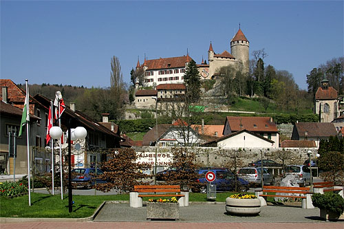
Payerne
- municipality in Switzerland
Hiking in Payerne
Payerne, located in the canton of Vaud in Switzerland, is surrounded by beautiful landscapes that offer various hiking opportunities. Here are some insights into hiking in and around Payerne:...
- Country:
- Postal Code: 1530
- Local Dialing Code: 026
- Licence Plate Code: VD
- Coordinates: 46° 49' 0" N, 6° 56' 0" E
- GPS tracks (wikiloc): [Link]
- AboveSeaLevel: 456 м m
- Area: 24.19 sq km
- Population: 9699
- Web site: [Link]

Vucherens
- municipality in Switzerland
Hiking in Vucherens
Vucherens is a small municipality located in the Vaud region of Switzerland, surrounded by picturesque landscapes, rolling hills, and lush greenery. While it may not be as famous for hiking as some of the larger Swiss destinations, it offers a number of lovely trails that are perfect for a quiet day outdoors....
- Country:
- Postal Code: 1509
- Local Dialing Code: 021
- Licence Plate Code: VD
- Coordinates: 46° 37' 0" N, 6° 48' 0" E
- GPS tracks (wikiloc): [Link]
- AboveSeaLevel: 678 м m
- Area: 3.26 sq km
- Population: 582
- Web site: [Link]
Lucens
- municipality in Switzerland
Hiking in Lucens
Lucens is a charming village located in the Swiss canton of Vaud, surrounded by picturesque landscapes that make it an excellent destination for hiking enthusiasts. The area features a variety of trails that cater to different skill levels, allowing everyone from beginners to seasoned hikers to enjoy the beautiful Swiss countryside....
- Country:
- Postal Code: 1522, 1526, 1683
- Local Dialing Code: 021
- Licence Plate Code: VD
- Coordinates: 46° 42' 33" N, 6° 50' 14" E
- GPS tracks (wikiloc): [Link]
- AboveSeaLevel: 500 м m
- Area: 7.86 sq km
- Population: 4133
- Web site: [Link]

Grandcour
- municipality in Switzerland
Hiking in Grandcour
Grandcour, a small village in the Canton of Vaud in Switzerland, offers a picturesque setting for hiking enthusiasts. While it may not be as widely known as some of the larger Swiss hiking destinations, the area surrounding Grandcour features charming trails that highlight the natural beauty of the region, including vineyards, rolling hills, and views of nearby lakes....
- Country:
- Postal Code: 1543
- Local Dialing Code: 026
- Licence Plate Code: VD
- Coordinates: 46° 52' 18" N, 6° 55' 44" E
- GPS tracks (wikiloc): [Link]
- AboveSeaLevel: 466 м m
- Area: 10.12 sq km
- Population: 888
- Web site: [Link]

Cudrefin
- municipality in Switzerland
Hiking in Cudrefin
Cudrefin, a charming village located on the shores of Lake Neuchâtel in Switzerland, offers beautiful hiking opportunities that showcase its picturesque landscapes and natural beauty. The area is characterized by its gentle hills, vineyards, and views of the lake and the surrounding Alps, making it an appealing destination for outdoor enthusiasts....
- Country:
- Postal Code: 1588
- Local Dialing Code: 026
- Licence Plate Code: VD
- Coordinates: 46° 57' 8" N, 7° 1' 37" E
- GPS tracks (wikiloc): [Link]
- AboveSeaLevel: 453 м m
- Area: 15.83 sq km
- Population: 1589
- Web site: [Link]


Moudon
- municipality in Switzerland
Hiking in Moudon
Moudon, located in the canton of Vaud in Switzerland, is surrounded by beautiful landscapes and offers a variety of hiking opportunities for both novice and experienced hikers. The region is characterized by rolling hills, picturesque meadows, and scenic views of the surrounding Alps....
- Country:
- Postal Code: 1510
- Local Dialing Code: 021
- Licence Plate Code: VD
- Coordinates: 46° 40' 7" N, 6° 47' 51" E
- GPS tracks (wikiloc): [Link]
- AboveSeaLevel: 618 м m
- Area: 15.68 sq km
- Population: 6187
- Web site: [Link]


Faoug
- municipality in Switzerland
Hiking in Faoug
Faoug, located in the canton of Vaud in Switzerland, is a small village situated along the shores of Lake Murten. It is surrounded by beautiful natural landscapes and offers a variety of hiking opportunities for outdoor enthusiasts....
- Country:
- Postal Code: 1595
- Local Dialing Code: 026
- Licence Plate Code: VD
- Coordinates: 46° 54' 9" N, 7° 4' 28" E
- GPS tracks (wikiloc): [Link]
- AboveSeaLevel: 477 м m
- Area: 3.47 sq km
- Population: 895
- Web site: [Link]

Prévonloup
- municipality in Switzerland
Hiking in Prévonloup
Prévonloup is a charming area located in Switzerland, particularly known for its picturesque landscapes and hiking trails. Nestled within the beautiful region of the Fribourg Alps, Prévonloup offers a variety of outdoor activities, with hiking being one of the most popular pursuits....
- Country:
- Postal Code: 1682
- Local Dialing Code: 026
- Licence Plate Code: VD
- Coordinates: 46° 42' 0" N, 6° 53' 0" E
- GPS tracks (wikiloc): [Link]
- AboveSeaLevel: 746 м m
- Area: 1.84 sq km
- Population: 160
- Web site: [Link]

Villars-le-Comte
- municipality in Switzerland
Hiking in Villars-le-Comte
Villars-le-Comte is a charming village in the Valais region of Switzerland, surrounded by stunning landscapes and offering a range of hiking opportunities. The area is characterized by its picturesque Alpine scenery, lush valleys, and diverse flora and fauna....
- Country:
- Postal Code: 1515
- Local Dialing Code: 021
- Licence Plate Code: VD
- Coordinates: 46° 43' 0" N, 6° 48' 0" E
- GPS tracks (wikiloc): [Link]
- AboveSeaLevel: 765 м m
- Area: 4.2 sq km
- Population: 142
- Web site: [Link]


Villarzel
- municipality in the district of Broye-Vully in the canton of Vaud in Switzerland
Hiking in Villarzel
Villarzel, a commune in the south of France located near the Aude department, offers a charming backdrop for hiking enthusiasts. The region is characterized by its picturesque landscapes, encompassing rolling hills, vineyards, and scenic views of the surrounding countryside. Here are some highlights for hiking in Villarzel:...
- Country:
- Postal Code: 1554, 1555
- Local Dialing Code: 026
- Licence Plate Code: VD
- Coordinates: 46° 45' 0" N, 6° 55' 0" E
- GPS tracks (wikiloc): [Link]
- AboveSeaLevel: 622 м m
- Area: 7.66 sq km
- Population: 416


Treytorrens
- municipality in Switzerland
Hiking in Treytorrens
Treytorrens, while not a widely recognized hiking destination in popular literature, might refer to a less-known region or a specific local area. If you are seeking hiking information in that location, here are some general guidelines and considerations that can enhance your hiking experience:...
- Country:
- Postal Code: 1538
- Local Dialing Code: 026
- Licence Plate Code: VD
- Coordinates: 46° 46' 0" N, 6° 48' 0" E
- GPS tracks (wikiloc): [Link]
- AboveSeaLevel: 661 м m
- Area: 3.07 sq km
- Population: 122
- Web site: [Link]


Missy
- municipality in Switzerland
Hiking in Missy
Hiking in Missy, Switzerland, offers a serene and picturesque experience in the midst of the Swiss Alps. While "Missy" itself might not refer to a specific location universally recognized for hiking, many idyllic regions and villages surrounding the Swiss Alps, like Mürren, Gimmelwald, or nearby areas that might share a name or be commonly associated with hiking, offer fantastic trails....
- Country:
- Postal Code: 1565
- Local Dialing Code: 026
- Licence Plate Code: VD
- Coordinates: 46° 52' 34" N, 6° 58' 26" E
- GPS tracks (wikiloc): [Link]
- AboveSeaLevel: 436 м m
- Area: 3.11 sq km
- Population: 351
- Web site: [Link]


Valbroye
- municipality in Switzerland
Hiking in Valbroye
Valbroye, a picturesque region in Switzerland, offers a variety of hiking opportunities that cater to different skill levels and preferences. The area is known for its stunning natural landscapes, including rolling hills, lakes, and forested areas, making it a great destination for both casual walkers and serious hikers....
- Country:
- Postal Code: 1523, 1524, 1525, 1534, 1535, 1536, 1682
- Licence Plate Code: VD
- Coordinates: 46° 45' 47" N, 6° 53' 13" E
- GPS tracks (wikiloc): [Link]
- AboveSeaLevel: 473 м m
- Area: 33.57 sq km
- Population: 3025
- Web site: [Link]


Vully-les-Lacs
- municipality in Switzerland
Hiking in Vully-les-Lacs
Vully-les-Lacs, located in the canton of Fribourg in Switzerland, offers a unique and picturesque hiking experience. Nestled between Lake Murten and Lake Neuchâtel, this region is characterized by rolling hills, vineyards, and stunning views of the surrounding lakes and mountains....
- Country:
- Postal Code: 1584, 1585, 1586, 1587, 1589, 1787
- Licence Plate Code: VD
- Coordinates: 46° 55' 27" N, 7° 1' 24" E
- GPS tracks (wikiloc): [Link]
- AboveSeaLevel: 533 м m
- Area: 21.15 sq km
- Population: 3086
- Web site: [Link]
Shares border with regions:

Jura-Nord vaudois District
- district of the canton of Vaud, Switzerland
Hiking in Jura-Nord vaudois District
Hiking in the Jura-Nord Vaudois District, located in the Jura Mountains of Switzerland, offers stunning landscapes, diverse flora and fauna, and a range of trails that cater to all skill levels. Here are some highlights:...
- Country:
- Capital: Yverdon-les-Bains
- Licence Plate Code: VD
- Coordinates: 46° 46' 0" N, 6° 38' 0" E
- GPS tracks (wikiloc): [Link]
- AboveSeaLevel: 654 м m
- Area: 702.61 sq km


Lavaux-Oron District
- district of the canton of Vaud, Switzerland
Hiking in Lavaux-Oron District
The Lavaux-Oron District, located in Switzerland, is renowned for its stunning landscapes, picturesque vineyards, and breathtaking views of Lake Geneva and the surrounding Alps. Here’s what you need to know about hiking in this beautiful area:...
- Country:
- Licence Plate Code: VD
- Coordinates: 46° 29' 0" N, 6° 44' 0" E
- GPS tracks (wikiloc): [Link]
- AboveSeaLevel: 683 м m
- Area: 134.57 sq km


Gros-de-Vaud District
- district of the canton of Vaud, Switzerland
Hiking in Gros-de-Vaud District
Gros-de-Vaud District, located in the canton of Vaud in Switzerland, offers a wonderful hiking experience with its picturesque landscapes, charming villages, and diverse terrain. Here are some highlights of hiking in this beautiful region:...
- Country:
- Capital: Echallens
- Licence Plate Code: VD
- Coordinates: 46° 37' 59" N, 6° 37' 59" E
- GPS tracks (wikiloc): [Link]
- AboveSeaLevel: 636 м m
- Area: 232.22 sq km