Urmein (Urmein)

- municipality in Switzerland
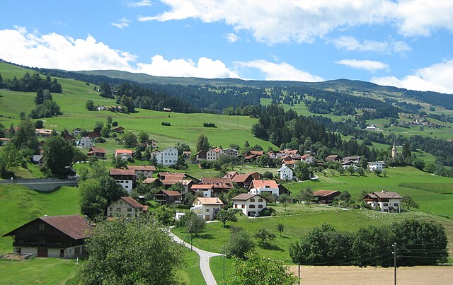
 Hiking in Urmein
Urmein, located in the Graubünden region of Switzerland, is an idyllic destination for hiking enthusiasts. Nestled amidst stunning alpine scenery, it offers a mix of easy walks and challenging trails suitable for various skill levels. Here are some highlights and tips for hiking in Urmein:
Trail Options
-
Local Trails: There are several well-marked local trails that connect Urmein to nearby valleys and mountain peaks. Many of these trails provide breathtaking views of the surrounding landscape and are often less crowded than more popular hiking destinations.
-
Scenic Routes: The hikes often lead through lush forests, along babbling brooks, and past charming Swiss chalets. Look for trails that pass through grassy meadows, especially in the summer months when wildflowers are in bloom.
-
Access to Higher Elevations: For more experienced hikers, trails leading up to the surrounding mountains offer a chance to reach higher elevations, providing panoramic views of the Swiss Alps.
Seasonal Considerations
- Summer Hiking: The best time for hiking in Urmein is typically from late spring to early autumn. Be sure to check trail conditions, as the higher elevations may still have snow in early summer.
- Autumn Colors: Fall brings vibrant colors to the landscape, making it an excellent time for photography and leisurely hikes.
Preparation and Safety
- Proper Gear: Always wear sturdy hiking boots and carry a daypack with sufficient water, snacks, a first-aid kit, and a map or GPS device.
- Weather Check: The weather can change rapidly in mountainous areas, so check the forecast before heading out and be prepared for varying conditions.
Wildlife and Nature
- Keep an eye out for local wildlife, including deer, marmots, and a variety of birds. Respect the natural environment by sticking to marked trails and avoiding disturbing the local fauna.
Cultural Aspects
Urmein is not just about hiking; it offers a glimpse into Swiss culture. Take time to explore the village, enjoy local cuisine, and perhaps stay in traditional accommodations for a complete experience.
Whether you're looking for a challenging trek or a leisurely stroll through nature, Urmein presents an excellent opportunity for outdoor adventure. Happy hiking!
- Country:

- Postal Code: 7427
- Local Dialing Code: 081
- Licence Plate Code: GR
- Coordinates: 46° 41' 9" N, 9° 24' 7" E


- GPS tracks (wikiloc): [Link]
- AboveSeaLevel: 1189 м m
- Area: 4.33 sq km
- Population: 146
- Wikipedia en: wiki(en)
- Wikipedia: wiki(de)
- Wikidata storage: Wikidata: Q64816
- Wikipedia Commons Category: [Link]
- Freebase ID: [/m/026g1r9]
- GeoNames ID: Alt: [7287391]
- VIAF ID: Alt: [131482695]
- OSM relation ID: [1684199]
- Library of Congress authority ID: Alt: [n91004789]
- HDS ID: [1494]
- Swiss municipality code: [3670]
Shares border with regions:
Flerden
- municipality in Switzerland
Hiking in Flerden
Flerden is a small village located in the scenic Swiss region of Graubünden. It's an ideal destination for hiking enthusiasts looking to explore the beautiful landscapes of the Swiss Alps. Here are some highlights and tips for hiking in and around Flerden:...
- Country:
- Postal Code: 7426
- Local Dialing Code: 081
- Licence Plate Code: GR
- Coordinates: 46° 41' 39" N, 9° 23' 33" E
- GPS tracks (wikiloc): [Link]
- AboveSeaLevel: 1408 м m
- Area: 6.09 sq km
- Population: 254
- Web site: [Link]

Masein
- municipality in Switzerland
Hiking in Masein
Masein, which is part of the more expansive region in Myanmar (Burma), offers a blend of lush landscapes, cultural richness, and opportunities for adventurous hiking. Here are some key highlights:...
- Country:
- Postal Code: 7425
- Local Dialing Code: 081
- Licence Plate Code: GR
- Coordinates: 46° 41' 50" N, 9° 25' 23" E
- GPS tracks (wikiloc): [Link]
- AboveSeaLevel: 942 м m
- Area: 4.2 sq km
- Population: 481
- Web site: [Link]


Tschappina
- municipality in Switzerland
Hiking in Tschappina
Tschappina, a small village located in the Graubünden region of Switzerland, is a great spot for hiking enthusiasts. Nestled in the beautiful Alps, it offers a variety of trails that cater to different skill levels and preferences. Here’s what you can expect when hiking in Tschappina:...
- Country:
- Postal Code: 7428
- Local Dialing Code: 081
- Licence Plate Code: GR
- Coordinates: 46° 40' 36" N, 9° 21' 38" E
- GPS tracks (wikiloc): [Link]
- AboveSeaLevel: 1699 м m
- Area: 24.67 sq km
- Population: 129
- Web site: [Link]


Thusis
- municipality in Switzerland
Hiking in Thusis
Thusis, located in the canton of Graubünden in Switzerland, is a great destination for hikers. It sits at the confluence of the Rhine and Hinterrhein rivers and offers stunning views of the surrounding mountains and valleys....
- Country:
- Postal Code: 7430
- Local Dialing Code: 081
- Licence Plate Code: GR
- Coordinates: 46° 41' 19" N, 9° 25' 58" E
- GPS tracks (wikiloc): [Link]
- AboveSeaLevel: 805 м m
- Area: 6.81 sq km
- Population: 3138
- Web site: [Link]


Lohn
- municipality in Graubünden, Switzerland
Hiking in Lohn
Lohn is a picturesque village in the Graubünden region of Switzerland, known for its stunning alpine scenery and outdoor recreational opportunities. It lies at an elevation of about 1,300 meters, making it an excellent base for various hiking trails that cater to different skill levels....
- Country:
- Postal Code: 7433
- Local Dialing Code: 081
- Licence Plate Code: GR
- Coordinates: 46° 39' 5" N, 9° 25' 39" E
- GPS tracks (wikiloc): [Link]
- AboveSeaLevel: 1817 м m
- Area: 8.17 sq km
- Population: 42
- Web site: [Link]