
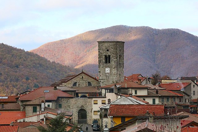
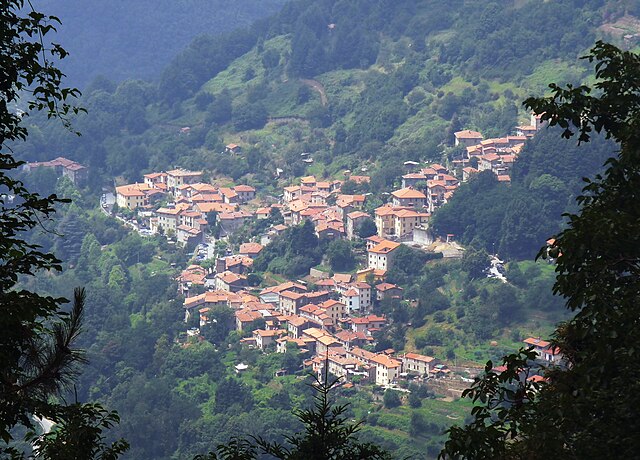
Vagli Sotto (Vagli Sotto)
.svg)
- Italian comune
 Hiking in Vagli Sotto
Vagli Sotto is a picturesque village located in Tuscany, Italy, nestled in the Apuan Alps. The area around Vagli Sotto offers stunning hiking opportunities, characterized by its diverse landscapes, rich flora and fauna, and breathtaking views. Here are some highlights to consider if you're planning a hike in this region:
Trails and Routes
-
Panoramic Trails: Vagli Sotto boasts several trails that provide panoramic views of the surrounding mountains and valleys. Look for routes that take you to viewpoints like Monte Guglielmo or Monte Matanna.
-
Historical Paths: Many trails in the region are linked to historical routes, where you can explore remnants of ancient shepherd paths and old settlements.
-
Vagli Lake: The lake itself is a beautiful spot for hiking. You can follow paths that circumnavigate the lake, offering an opportunity to enjoy the tranquility of the water and the surrounding nature.
-
Forest Trails: The Apuan Alps are home to lush forests. Trails surrounded by beech, chestnut, and fir trees provide a cooler hiking experience, especially during the hot summer months.
Difficulty Levels
- Beginner: There are easier trails suitable for beginners and families. These often have gentle slopes and well-marked paths.
- Intermediate to Advanced: For more experienced hikers, there are challenging routes with steeper ascents and rugged terrains, especially those leading up to higher peaks.
Wildlife and Nature
The area is rich in biodiversity. Keep an eye out for various birds, deer, and other wildlife, and enjoy the unique plant life that thrives in the alpine environment.
Best Time to Hike
- Spring (April to June): Great time for wildflowers and pleasant temperatures.
- Autumn (September to October): The foliage changes color, creating a beautiful landscape. Temperatures are also mild for hiking.
- Summer (July to August): Can be hot, but there are higher elevation trails where cooler temperatures can be found.
- Winter (December to March): Some trails may be accessible for winter hiking, but snow can cover higher elevations, so check conditions and be prepared with appropriate gear.
Preparation and Safety
- Gear: Wear appropriate hiking footwear, and bring layers, as mountain weather can change rapidly. Don't forget a map, compass or a GPS device, along with plenty of water and snacks.
- Local Advice: It's a good idea to check in with local hiking groups or visitor centers for trail conditions and any safety tips.
Getting There
Vagli Sotto can be accessed from larger towns like Lucca or Massa. It’s ideal to have a car for greater flexibility in exploring the area and accessing trailheads.
Overall, hiking in Vagli Sotto can be a rewarding experience with its stunning natural beauty, historical significance, and tranquil atmosphere. Make sure to leave no trace, respect local wildlife, and enjoy your adventure!
- Country:

- Postal Code: 55030
- Local Dialing Code: 0583
- Licence Plate Code: LU
- Coordinates: 44° 7' 0" N, 10° 17' 0" E


- GPS tracks (wikiloc): [Link]
- AboveSeaLevel: 600 м m
- Area: 41.22 sq km
- Population: 930
- Web site: http://www.comune.vagli-sotto.lu.it
- Wikipedia en: wiki(en)
- Wikipedia: wiki(it)
- Wikidata storage: Wikidata: Q221311
- Wikipedia Commons Category: [Link]
- Freebase ID: [/m/0glbgj]
- GeoNames ID: Alt: [6540277]
- VIAF ID: Alt: [264606328]
- OSM relation ID: [42843]
- GND ID: Alt: [7612218-9]
- Library of Congress authority ID: Alt: [nr94009998]
- WOEID: [12682320]
- ISTAT ID: 046031
- Italian cadastre code: L533
Shares border with regions:


Massa
- capital of the Province of Massa and Carrara
Hiking in Massa
Massa, located in the Tuscany region of Italy, is a stunning destination for hiking enthusiasts, offering a mix of coastal and mountainous landscapes. Here are some key highlights of hiking in Massa:...
- Country:
- Postal Code: 54100
- Local Dialing Code: 0585
- Licence Plate Code: MS
- Coordinates: 44° 2' 0" N, 10° 8' 0" E
- GPS tracks (wikiloc): [Link]
- AboveSeaLevel: 65 м m
- Area: 93.84 sq km
- Population: 69226
- Web site: [Link]


Camporgiano
- Italian comune
Hiking in Camporgiano
Camporgiano is a charming village located in the Garfagnana region of Tuscany, Italy. This area is known for its stunning landscapes, including valleys, mountains, and rich natural flora and fauna, making it an excellent destination for hiking enthusiasts....
- Country:
- Postal Code: 55031
- Local Dialing Code: 0583
- Licence Plate Code: LU
- Coordinates: 44° 9' 39" N, 10° 20' 4" E
- GPS tracks (wikiloc): [Link]
- AboveSeaLevel: 475 м m
- Area: 27.09 sq km
- Population: 2137
- Web site: [Link]

Careggine
- Italian comune
Hiking in Careggine
Careggine, located in the Apuan Alps in Tuscany, Italy, is a beautiful destination for hiking enthusiasts. The region is characterized by stunning mountain landscapes, lush forests, and a variety of trails suitable for different skill levels....
- Country:
- Postal Code: 55030
- Local Dialing Code: 0583
- Licence Plate Code: LU
- Coordinates: 44° 7' 15" N, 10° 19' 35" E
- GPS tracks (wikiloc): [Link]
- AboveSeaLevel: 882 м m
- Area: 24.08 sq km
- Population: 539
- Web site: [Link]


Minucciano
- Italian comune
Hiking in Minucciano
Minucciano is a charming village situated in the province of Lucca in Tuscany, Italy, surrounded by the stunning landscapes of the Apuan Alps. Hiking in and around Minucciano offers a fantastic opportunity to explore the region’s natural beauty, rich history, and diverse fauna and flora....
- Country:
- Postal Code: 55034
- Local Dialing Code: 0583
- Licence Plate Code: LU
- Coordinates: 44° 10' 0" N, 10° 13' 0" E
- GPS tracks (wikiloc): [Link]
- AboveSeaLevel: 697 м m
- Area: 57.28 sq km
- Population: 2024
- Web site: [Link]

Stazzema
- Italian comune
Hiking in Stazzema
Stazzema, located in the Apuan Alps of Tuscany, Italy, is a wonderful destination for hiking enthusiasts. This area is known for its stunning landscapes, rich history, and diverse wildlife. Here are some key points to consider when hiking in and around Stazzema:...
- Country:
- Postal Code: 55040; 55060
- Local Dialing Code: 0584
- Licence Plate Code: LU
- Coordinates: 43° 59' 35" N, 10° 18' 38" E
- GPS tracks (wikiloc): [Link]
- AboveSeaLevel: 453 м m
- Area: 82.08 sq km
- Population: 3083
- Web site: [Link]