Valdieri (Valdieri)
- Italian comune
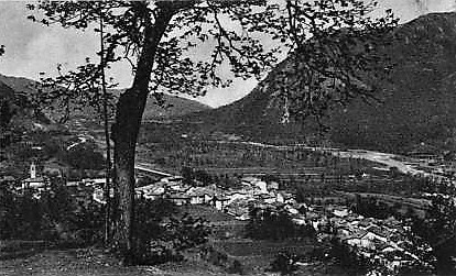
Valdieri is a picturesque town located in the Piedmont region of Italy, and it serves as an excellent gateway for hiking enthusiasts looking to explore the stunning landscapes of the Maritime Alps. Here are some highlights of hiking in Valdieri:
Scenic Routes
-
Parco Naturale delle Alpi Marittime: This natural park features a variety of trails tailored for different skill levels, allowing hikers to experience breathtaking mountain scenery, lush forests, and clear alpine lakes.
-
The Vallone di Bellino: This valley is known for its dramatic landscapes and offers several trails that lead to remarkable viewpoints and natural attractions.
-
Valdieri-Molino delle Fucine: An easy to moderate hike that follows the river and offers opportunities to see waterfalls, wildflowers, and local wildlife.
-
Monte Saccarello: Considered one of the higher peaks in the area, this hike is suited for experienced hikers. It provides panoramic views that are particularly stunning on clear days.
Flora and Fauna
The area around Valdieri is rich in biodiversity. Hikers might encounter various species of flowers, such as edelweiss and various orchids, along with wildlife like chamois, marmots, and a variety of birds.
Best Time to Hike
The ideal time for hiking in Valdieri typically ranges from late spring to early autumn (May to September). During this period, the weather is more stable, and the trails are generally accessible.
Preparations
- Equipment: Ensure you have appropriate footwear, plenty of water, and snacks. A map or a GPS device is also useful for navigation.
- Weather: Mountain weather can change quickly, so it's advisable to check the forecast and prepare for varying conditions.
- Safety: Inform someone about your hiking plans and expected return time, especially if heading into more remote areas.
Local Culture and Amenities
Valdieri has a charming alpine atmosphere, with opportunities to enjoy local cuisine in its eateries after a day of hiking. The town also offers various accommodations ranging from hotels to guesthouses, catering to different preferences.
Hiking in Valdieri can be a rewarding experience as it combines natural beauty with cultural richness, making it an ideal destination for outdoor enthusiasts.
- Country:

- Postal Code: 12010
- Local Dialing Code: 0171
- Licence Plate Code: CN
- Coordinates: 44° 17' 0" N, 7° 24' 0" E


- GPS tracks (wikiloc): [Link]
- AboveSeaLevel: 774 м m
- Area: 153.32 sq km
- Population: 932
- Web site: http://www.comune.valdieri.cn.it
- Wikipedia en: wiki(en)
- Wikipedia: wiki(it)
- Wikidata storage: Wikidata: Q20523
- Wikipedia Commons Category: [Link]
- Freebase ID: [/m/0gbdz6]
- GeoNames ID: Alt: [6539910]
- VIAF ID: Alt: [244350203]
- OSM relation ID: [42938]
- ISTAT ID: 004233
- Italian cadastre code: L558
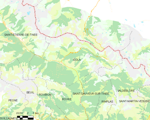
Shares border with regions:


Valdeblore
- commune in Alpes-Maritimes, France
Valdeblore is a beautiful valley located in the French Alps, in the Alpes-Maritimes department of the Provence-Alpes-Côte d'Azur region. It's known for its stunning landscapes, diverse flora and fauna, and excellent hiking opportunities. Here are some key points about hiking in Valdeblore:...
- Country:

- Postal Code: 06420
- Coordinates: 44° 4' 15" N, 7° 10' 16" E


- GPS tracks (wikiloc): [Link]
- AboveSeaLevel: 1050 м m
- Area: 94.16 sq km
- Population: 848
- Web site: [Link]

Aisone
- Italian comune
Aisone is a small town located in the Piedmont region of northwestern Italy, within the province of Cuneo. Nestled in the Valle Stura, Aisone is surrounded by stunning natural landscapes, making it an excellent starting point for hiking enthusiasts....
- Country:

- Postal Code: 12010
- Local Dialing Code: 0171
- Licence Plate Code: CN
- Coordinates: 44° 19' 0" N, 7° 13' 0" E


- GPS tracks (wikiloc): [Link]
- AboveSeaLevel: 834 м m
- Area: 36.92 sq km
- Population: 236
- Web site: [Link]

Borgo San Dalmazzo
- Italian comune
Borgo San Dalmazzo, located in the Piedmont region of Italy, is a charming town situated near the foothills of the Alps. It serves as a great base for outdoor activities, including hiking, due to its picturesque landscapes and proximity to the Maritime Alps. Here are some highlights about hiking in this area:...
- Country:

- Postal Code: 12011
- Local Dialing Code: 0171
- Licence Plate Code: CN
- Coordinates: 44° 20' 0" N, 7° 29' 0" E


- GPS tracks (wikiloc): [Link]
- AboveSeaLevel: 645 м m
- Area: 22.34 sq km
- Population: 12492
- Web site: [Link]

Demonte
- Italian comune
Demonte, located in the Italian region of Piedmont near the French border, is a fantastic destination for hiking enthusiasts. Nestled in the Cottian Alps, the area boasts stunning landscapes, diverse flora and fauna, and a rich cultural heritage. Here are some highlights for hiking in Demonte:...
- Country:

- Postal Code: 12014
- Local Dialing Code: 0171
- Licence Plate Code: CN
- Coordinates: 44° 19' 0" N, 7° 18' 0" E


- GPS tracks (wikiloc): [Link]
- AboveSeaLevel: 780 м m
- Area: 127.31 sq km
- Population: 1983
- Web site: [Link]

Entracque
- Italian comune
Entracque is a picturesque village located in the Piedmont region of Italy, nestled in the stunning Maritime Alps. It's an excellent destination for hiking enthusiasts, offering a range of trails that cater to various skill levels, from beginners to advanced hikers. Here are some highlights of hiking in Entracque:...
- Country:

- Postal Code: 12010
- Local Dialing Code: 0171
- Licence Plate Code: CN
- Coordinates: 44° 14' 33" N, 7° 24' 0" E


- GPS tracks (wikiloc): [Link]
- AboveSeaLevel: 894 м m
- Area: 160.73 sq km
- Population: 848
- Web site: [Link]

Moiola
- Italian comune
Moiola is a picturesque location in the Italian Alps, specifically in the Piedmont region known for its stunning natural landscapes and excellent hiking opportunities. The area is characterized by its beautiful mountains, lush valleys, and diverse ecosystems, making it a great destination for both novice and experienced hikers....
- Country:

- Postal Code: 12010
- Local Dialing Code: 0171
- Licence Plate Code: CN
- Coordinates: 44° 19' 0" N, 7° 23' 0" E


- GPS tracks (wikiloc): [Link]
- AboveSeaLevel: 689 м m
- Area: 15.07 sq km
- Population: 232
- Web site: [Link]

Roaschia
- Italian comune
Roaschia, located in the mountains of Romania, is a lesser-known hiking destination that offers beautiful landscapes and a range of trails suitable for various skill levels. Here are some key points to consider when hiking in Roaschia:...
- Country:

- Postal Code: 12010
- Local Dialing Code: 0171
- Licence Plate Code: CN
- Coordinates: 44° 16' 0" N, 7° 27' 0" E


- GPS tracks (wikiloc): [Link]
- AboveSeaLevel: 822 м m
- Area: 23.84 sq km
- Population: 105
- Web site: [Link]

Roccavione
- Italian comune
Roccavione is a small town located in the Piedmont region of northern Italy, nestled near the Cottian Alps. While it might not be as widely known as some other hiking destinations in Italy, it offers some beautiful trails and stunning natural scenery....
- Country:

- Postal Code: 12018
- Local Dialing Code: 0171
- Licence Plate Code: CN
- Coordinates: 44° 19' 0" N, 7° 29' 0" E


- GPS tracks (wikiloc): [Link]
- AboveSeaLevel: 646 м m
- Area: 19.15 sq km
- Population: 2648
- Web site: [Link]

Vinadio
- Italian comune
Vinadio, a charming village nestled in the Piedmont region of Italy, is an excellent destination for hiking enthusiasts. Situated in the upper part of the Stura Valley, it's surrounded by the stunning Maritime Alps, making it a perfect spot for both casual walkers and experienced hikers....
- Country:

- Postal Code: 12010
- Local Dialing Code: 0171
- Licence Plate Code: CN
- Coordinates: 44° 18' 0" N, 7° 10' 0" E


- GPS tracks (wikiloc): [Link]
- AboveSeaLevel: 904 м m
- Area: 183.17 sq km
- Population: 629
- Web site: [Link]


Isola
- commune in Alpes-Maritimes, France
Isola is a charming village located in the Alpes-Maritimes region of France, renowned for its stunning natural landscapes and outdoor activities, especially hiking. Situated in the heart of the Southern Alps, Isola offers a variety of trails that cater to different skill levels, from leisurely walks to more challenging hikes....
- Country:

- Postal Code: 06420
- Coordinates: 44° 11' 9" N, 7° 3' 8" E


- GPS tracks (wikiloc): [Link]
- Area: 97.98 sq km
- Population: 693


Saint-Martin-Vésubie
- commune in Alpes-Maritimes, France
 Hiking in Saint-Martin-Vésubie
Saint-Martin-Vésubie is a picturesque village located in the Alpes-Maritimes department in the Provence-Alpes-Côte d'Azur region of France. It serves as an excellent base for hiking enthusiasts due to its proximity to the Mercantour National Park and stunning alpine landscapes. Here are some key highlights about hiking in this area:...
- Country:

- Postal Code: 06450
- Coordinates: 44° 4' 6" N, 7° 15' 21" E


- GPS tracks (wikiloc): [Link]
- Area: 97.13 sq km
- Population: 1394
- Web site: [Link]