
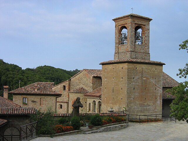
Varzi (Varzi)
.svg)
- Italian comune
 Hiking in Varzi
Varzi, located in the Lombardy region of Italy, is a lovely destination for hiking enthusiasts due to its beautiful landscapes and diverse terrain. Here are some highlights about hiking in and around Varzi:
Scenic Trails
-
Sentiero dei Barchi: This trail takes you through local forests and offers stunning views of the surrounding hills. It is well-marked and suitable for various skill levels.
-
Valli del Gorrini: A trail that explores the valleys near Varzi, this hike can include picturesque streams and rich flora. It's great for those who love nature photography.
-
Monte Delle Foppe: For more experienced hikers, this route leads you up to one of the higher peaks in the region, where you're rewarded with panoramic views of the Oltrepò Pavese area.
Wildlife and Flora
The hiking paths around Varzi often traverse areas that are rich in biodiversity. Keep an eye out for local wildlife, including different bird species, deer, and various plant species that thrive in the Italian uplands.
Historic Sites
Many trails can lead you to historic ruins, charming old towns, and ancient churches. This not only adds a cultural element to your hike but can also provide resting points where you can enjoy local cuisine.
Best Time to Hike
The best time for hiking in Varzi is typically from spring (April to June) and early autumn (September to October). During these months, the weather is usually mild, and the countryside is lush and vibrant.
Preparation Tips
- Wear Appropriate Gear: Good hiking boots, comfortable clothing, and weather-appropriate gear are essential.
- Stay Hydrated: Carry enough water, especially on longer hikes.
- Navigation: While many trails are well-marked, having a map or a GPS device can be helpful if you plan to explore less-known routes.
Local Cuisine
After a long day of hiking, be sure to indulge in the local cuisine. Varzi is known for its salami, cheeses, and exquisite wines, making it a perfect reward after a day spent in nature.
Conclusion
Hiking in Varzi offers a combination of natural beauty, historical insights, and a rich cultural experience. Whether you’re an experienced hiker or a beginner, the trails around this charming town provide something for everyone.
- Country:

- Postal Code: 27057
- Local Dialing Code: 0383
- Licence Plate Code: PV
- Coordinates: 44° 49' 0" N, 9° 12' 0" E


- GPS tracks (wikiloc): [Link]
- AboveSeaLevel: 426 м m
- Area: 57.61 sq km
- Population: 3194
- Web site: http://www.comune.varzi.pv.it
- Wikipedia en: wiki(en)
- Wikipedia: wiki(it)
- Wikidata storage: Wikidata: Q40474
- Wikipedia Commons Category: [Link]
- Freebase ID: [/m/0gjxwy]
- GeoNames ID: Alt: [6537206]
- VIAF ID: Alt: [237464832]
- OSM relation ID: [43624]
- GND ID: Alt: [4706789-5]
- archINFORM location ID: [46141]
- ISTAT ID: 018171
- Italian cadastre code: L690
Shares border with regions:

Fabbrica Curone
- municipality in Italy
Hiking in Fabbrica Curone
Fabbrica Curone is a beautiful area located in the province of Alessandria, in the Piedmont region of Italy. Nestled in the Apennine Mountains, this area offers a variety of hiking opportunities for nature lovers and outdoor enthusiasts. Here are some highlights and tips for hiking in Fabbrica Curone:...
- Country:
- Postal Code: 15054
- Local Dialing Code: 0131
- Licence Plate Code: AL
- Coordinates: 44° 45' 19" N, 9° 9' 18" E
- GPS tracks (wikiloc): [Link]
- AboveSeaLevel: 440 м m
- Area: 53.84 sq km
- Population: 631
- Web site: [Link]

Gremiasco
- municipality in Italy
Hiking in Gremiasco
Gremiasco is a charming village located in the Piedmont region of Italy, surrounded by the beautiful scenery of the Italian Alps. While it may not be one of the most recognized hiking destinations, it offers opportunities for nature enthusiasts and hikers looking for a less crowded experience....
- Country:
- Postal Code: 15050
- Local Dialing Code: 0131
- Licence Plate Code: AL
- Coordinates: 44° 47' 50" N, 9° 6' 28" E
- GPS tracks (wikiloc): [Link]
- AboveSeaLevel: 395 м m
- Area: 17.38 sq km
- Population: 318
- Web site: [Link]


Bagnaria
- Italian comune
Hiking in Bagnaria
Bagnaria is a small village located in the province of Pavia, Lombardy, Italy, known for its picturesque landscapes and natural beauty. While it may not be as popular as some larger hiking destinations, it does offer opportunities for light to moderate hiking with a focus on enjoying the tranquility of nature....
- Country:
- Postal Code: 27050
- Local Dialing Code: 0383
- Licence Plate Code: PV
- Coordinates: 44° 50' 0" N, 9° 7' 0" E
- GPS tracks (wikiloc): [Link]
- AboveSeaLevel: 333 м m
- Area: 16.66 sq km
- Population: 666
- Web site: [Link]


Santa Margherita di Staffora
- Italian comune
Hiking in Santa Margherita di Staffora
Santa Margherita di Staffora is a charming village located in the Province of Pavia, in the Lombardy region of northern Italy. Nestled in the scenic Staffora Valley in the Appennino Pavese, it offers a variety of hiking opportunities, characterized by beautiful landscapes, wooded trails, and panoramic views of the surrounding mountains....
- Country:
- Postal Code: 27050
- Local Dialing Code: 0383
- Licence Plate Code: PV
- Coordinates: 44° 44' 0" N, 9° 17' 0" E
- GPS tracks (wikiloc): [Link]
- AboveSeaLevel: 550 м m
- Area: 36.9 sq km
- Population: 478
- Web site: [Link]


Val di Nizza
- Italian comune
Hiking in Val di Nizza
Val di Nizza is a beautiful valley located in the Piedmont region of Italy, specifically in the province of Pavia. It's known for its stunning landscapes, rich biodiversity, and charming villages, making it a fantastic destination for hikers of all levels....
- Country:
- Postal Code: 27050
- Local Dialing Code: 0383
- Licence Plate Code: PV
- Coordinates: 44° 53' 0" N, 9° 10' 0" E
- GPS tracks (wikiloc): [Link]
- AboveSeaLevel: 412 м m
- Area: 29.68 sq km
- Population: 626
- Web site: [Link]


Zavattarello
- Italian comune
Hiking in Zavattarello
Zavattarello is a charming village located in the province of Pavia, Lombardy, Italy. It is surrounded by the beautiful landscapes of the Oltrepò Pavese region, making it an excellent destination for hiking enthusiasts. Here are some key points about hiking in Zavattarello:...
- Country:
- Postal Code: 27059
- Local Dialing Code: 0383
- Licence Plate Code: PV
- Coordinates: 44° 52' 0" N, 9° 16' 0" E
- GPS tracks (wikiloc): [Link]
- AboveSeaLevel: 366 м m
- Area: 28.4 sq km
- Population: 1023
- Web site: [Link]


Romagnese
- Italian comune
Hiking in Romagnese
Romagnese is a beautiful destination for hiking enthusiasts located in the Lombardy region of northern Italy. Nestled in the Appennino Piacentino, this area is known for its stunning natural landscapes, rolling hills, forests, and a variety of trails catering to different skill levels. Here’s what you can expect when hiking in Romagnese:...
- Country:
- Postal Code: 27050
- Local Dialing Code: 0383
- Licence Plate Code: PV
- Coordinates: 44° 50' 0" N, 9° 20' 0" E
- GPS tracks (wikiloc): [Link]
- AboveSeaLevel: 630 м m
- Area: 29.72 sq km
- Population: 669
- Web site: [Link]
Menconico
- Italian comune
Hiking in Menconico
Menconico is a small village located in the Lombardy region of Italy, surrounded by beautiful landscapes and natural features that make it an appealing destination for hikers. Here are some details about hiking in and around Menconico:...
- Country:
- Postal Code: 27050
- Local Dialing Code: 0383
- Licence Plate Code: PV
- Coordinates: 44° 48' 0" N, 9° 17' 0" E
- GPS tracks (wikiloc): [Link]
- AboveSeaLevel: 728 м m
- Area: 28.14 sq km
- Population: 357
- Web site: [Link]

Ponte Nizza
- Italian comune
Hiking in Ponte Nizza
Ponte Nizza, located in the province of Pavia in Lombardy, Italy, is an excellent destination for hiking enthusiasts. Nestled in a scenic area characterized by rolling hills, forests, and rivers, it offers a variety of trails suitable for different skill levels....
- Country:
- Postal Code: 27050
- Local Dialing Code: 0383
- Licence Plate Code: PV
- Coordinates: 44° 51' 0" N, 9° 6' 0" E
- GPS tracks (wikiloc): [Link]
- AboveSeaLevel: 267 м m
- Area: 22.96 sq km
- Population: 785
- Web site: [Link]