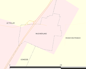
Vaudherland (Vaudherland)
- commune in Val-d'Oise, France
- Country:

- Postal Code: 95500
- Coordinates: 49° 0' 2" N, 2° 29' 10" E


- GPS tracks (wikiloc): [Link]
- Area: 0.09 sq km
- Population: 79
- Web site: http://www.vaudherland.fr
- Wikipedia en: wiki(en)
- Wikipedia: wiki(fr)
- Wikidata storage: Wikidata: Q255775
- Wikipedia Commons Category: [Link]
- Freebase ID: [/m/03qlm_4]
- Freebase ID: [/m/03qlm_4]
- GeoNames ID: Alt: [6446348]
- GeoNames ID: Alt: [6446348]
- SIREN number: [219506334]
- SIREN number: [219506334]
- BnF ID: [152805398]
- BnF ID: [152805398]
- INSEE municipality code: 95633
- INSEE municipality code: 95633
Shares border with regions:


Le Thillay
- commune in Val-d'Oise, France
- Country:

- Postal Code: 95500
- Coordinates: 49° 0' 17" N, 2° 28' 15" E


- GPS tracks (wikiloc): [Link]
- Area: 3.94 sq km
- Population: 4298
- Web site: [Link]


Gonesse
- commune in Val-d'Oise, France
- Country:

- Postal Code: 95500
- Coordinates: 48° 59' 12" N, 2° 26' 55" E


- GPS tracks (wikiloc): [Link]
- AboveSeaLevel: 53 м m
- Area: 20.09 sq km
- Population: 26142
- Web site: [Link]


Roissy-en-France
- commune in Val-d'Oise, France
- Country:

- Postal Code: 95700
- Coordinates: 49° 0' 15" N, 2° 31' 5" E


- GPS tracks (wikiloc): [Link]
- AboveSeaLevel: 100 м m
- Area: 14.09 sq km
- Population: 2877
- Web site: [Link]
