Venerque (Venerque)

- commune in Haute-Garonne, France
- Country:

- Postal Code: 31810
- Coordinates: 43° 26' 1" N, 1° 26' 38" E


- GPS tracks (wikiloc): [Link]
- Area: 14.57 sq km
- Population: 2560
- Web site: http://www.mairie-venerque.fr
- Wikipedia en: wiki(en)
- Wikipedia: wiki(fr)
- Wikidata storage: Wikidata: Q1440950
- Wikipedia Commons Category: [Link]
- Freebase ID: [/m/03nq2tt]
- GeoNames ID: Alt: [2970086]
- SIREN number: [213105729]
- BnF ID: [152555673]
- PACTOLS thesaurus ID: [pcrtoEl6qK4ThF]
- WOEID: [630574]
- INSEE municipality code: 31572
Shares border with regions:

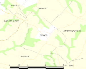
Espanès
- commune in Haute-Garonne, France
- Country:
- Postal Code: 31450
- Coordinates: 43° 27' 10" N, 1° 29' 19" E
- GPS tracks (wikiloc): [Link]
- Area: 3.53 sq km
- Population: 316
- Web site: [Link]

Vernet
- commune in Haute-Garonne, France
- Country:
- Postal Code: 31810
- Coordinates: 43° 25' 58" N, 1° 25' 54" E
- GPS tracks (wikiloc): [Link]
- AboveSeaLevel: 166 м m
- Area: 10.53 sq km
- Population: 2693
- Web site: [Link]

Grépiac
- commune in Haute-Garonne, France
- Country:
- Postal Code: 31190
- Coordinates: 43° 24' 18" N, 1° 26' 55" E
- GPS tracks (wikiloc): [Link]
- Area: 8.18 sq km
- Population: 990
- Web site: [Link]

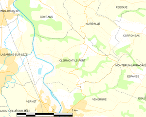
Clermont-le-Fort
- commune in Haute-Garonne, France
- Country:
- Postal Code: 31810
- Coordinates: 43° 27' 29" N, 1° 25' 57" E
- GPS tracks (wikiloc): [Link]
- Area: 10.04 sq km
- Population: 512
- Web site: [Link]


Issus
- commune in Haute-Garonne, France
- Country:
- Postal Code: 31450
- Coordinates: 43° 25' 25" N, 1° 30' 22" E
- GPS tracks (wikiloc): [Link]
- Area: 7.11 sq km
- Population: 583
- Web site: [Link]