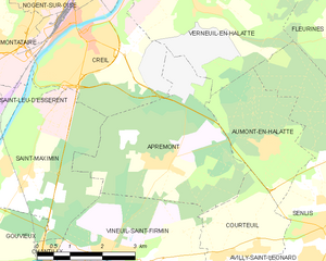
Verneuil-en-Halatte (Verneuil-en-Halatte)
- commune in Oise, France
- Country:

- Postal Code: 60550
- Coordinates: 49° 16' 35" N, 2° 31' 20" E


- GPS tracks (wikiloc): [Link]
- Area: 22.26 sq km
- Population: 4690
- Web site: http://www.verneuil-en-halatte.fr
- Wikipedia en: wiki(en)
- Wikipedia: wiki(fr)
- Wikidata storage: Wikidata: Q1389275
- Wikipedia Commons Category: [Link]
- Freebase ID: [/m/03qg7jq]
- GeoNames ID: Alt: [2969806]
- SIREN number: [216006619]
- BnF ID: [15267903n]
- archINFORM location ID: [8238]
- Library of Congress authority ID: Alt: [no2007140912]
- PACTOLS thesaurus ID: [pcrtRhWGX1dJ60]
- MusicBrainz area ID: [fb7acf76-52ee-47bd-a2e2-44d0204e895a]
- Pleiades ID: [109418]
- INSEE municipality code: 60670
Shares border with regions:


Beaurepaire
- commune in Oise, France
- Country:

- Postal Code: 60700
- Coordinates: 49° 17' 38" N, 2° 34' 17" E


- GPS tracks (wikiloc): [Link]
- Area: 5.07 sq km
- Population: 63
- Web site: [Link]


Aumont-en-Halatte
- commune in Oise, France
- Country:

- Postal Code: 60300
- Coordinates: 49° 14' 0" N, 2° 33' 0" E


- GPS tracks (wikiloc): [Link]
- AboveSeaLevel: 99 м m
- Area: 6.83 sq km
- Population: 503


Brenouille
- commune in Oise, France
- Country:

- Postal Code: 60870
- Coordinates: 49° 18' 11" N, 2° 32' 4" E


- GPS tracks (wikiloc): [Link]
- Area: 4.31 sq km
- Population: 2069
- Web site: [Link]


Senlis
- commune in Oise, France
- Country:

- Postal Code: 60300
- Coordinates: 49° 12' 26" N, 2° 35' 12" E


- GPS tracks (wikiloc): [Link]
- AboveSeaLevel: 76 м m
- Area: 24.05 sq km
- Population: 14777
- Web site: [Link]


Villers-Saint-Paul
- commune in Oise, France
- Country:

- Postal Code: 60870
- Coordinates: 49° 17' 20" N, 2° 29' 14" E


- GPS tracks (wikiloc): [Link]
- Area: 4.93 sq km
- Population: 6433
- Web site: [Link]


Creil
- commune in Oise, France
- Country:

- Postal Code: 60100
- Coordinates: 49° 15' 28" N, 2° 28' 58" E


- GPS tracks (wikiloc): [Link]
- AboveSeaLevel: 27 м m
- Area: 11.09 sq km
- Population: 35575
- Web site: [Link]


Apremont
- commune in Oise, France
- Country:

- Postal Code: 60300
- Coordinates: 49° 13' 24" N, 2° 30' 32" E


- GPS tracks (wikiloc): [Link]
- Area: 13.62 sq km
- Population: 679
- Web site: [Link]


Nogent-sur-Oise
- commune in Oise, France
- Country:

- Postal Code: 60180
- Coordinates: 49° 16' 29" N, 2° 28' 3" E


- GPS tracks (wikiloc): [Link]
- Area: 7.46 sq km
- Population: 19414
- Web site: [Link]


Rieux
- commune in Oise, France
- Country:

- Postal Code: 60870
- Coordinates: 49° 17' 59" N, 2° 31' 7" E


- GPS tracks (wikiloc): [Link]
- Area: 2.33 sq km
- Population: 1554
- Web site: [Link]


Fleurines
- commune in Oise, France
- Country:

- Postal Code: 60700
- Coordinates: 49° 15' 44" N, 2° 35' 8" E


- GPS tracks (wikiloc): [Link]
- Area: 11.95 sq km
- Population: 1905
- Web site: [Link]
