Vernioz (Vernioz)

- commune in Isère, France
 Hiking in Vernioz
Vernioz, located in the Auvergne-Rhône-Alpes region of France, is a charming destination for hikers. Nestled in the foothills of the Massif Central, it offers a scenic landscape with various trails suited for different skill levels and preferences.
Hiking Trails:
-
Local Nature Trails: The area has numerous well-marked trails that take you through forests, rolling hills, and charming countryside. Paths vary from easy walks to more challenging hikes.
-
Panoramic Routes: Some trails offer breathtaking panoramic views of the surrounding mountains and valleys, especially from higher elevations.
-
Flora and Fauna: The diverse ecosystems in this region host a range of wildlife and plant species, making hikes not only a physical activity but also an opportunity for nature observation.
Difficulty Levels:
- Easy: For families and casual walkers, look for shorter, flatter trails.
- Moderate: For those with some hiking experience, moderate trails offer a bit more challenge with varied terrain.
- Difficult: Experienced hikers can tackle more demanding routes that may involve steeper climbs and rougher paths.
Recommendations:
- Best Time to Visit: Spring and early fall are ideal due to mild weather and beautiful scenery. Summer can get warm, so plan early morning hikes.
- Safety: Always carry plenty of water, snacks, and a good map or GPS. Be aware of changing weather conditions.
Accessibility:
Vernioz is relatively accessible from major cities in the Rhône-Alpes region, making it a great spot for a day trip or weekend getaway for hikers.
Local Tips:
- Consider joining local hiking groups or guided tours to discover hidden gems and learn about the local environment.
- Don’t forget to enjoy the local cuisine after your hike; many eateries in the region offer delicious traditional dishes.
Remember to check local regulations and trail conditions before heading out to ensure a safe and enjoyable hiking experience!
- Country:

- Postal Code: 38150
- Coordinates: 45° 25' 19" N, 4° 54' 19" E


- GPS tracks (wikiloc): [Link]
- Area: 11.32 sq km
- Population: 1236
- Web site: http://vernioz.free.fr
- Wikipedia en: wiki(en)
- Wikipedia: wiki(fr)
- Wikidata storage: Wikidata: Q1067425
- Wikipedia Commons Category: [Link]
- Freebase ID: [/m/03nvjfr]
- GeoNames ID: Alt: [6433450]
- SIREN number: [213805369]
- BnF ID: [152583360]
- INSEE municipality code: 38536
Shares border with regions:

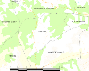
Chalon
- commune in Isère, France
Hiking in Chalon
Chalon, located in the Isère department of the Auvergne-Rhône-Alpes region in southeastern France, is surrounded by beautiful natural landscapes that offer various hiking opportunities. Here are some highlights of hiking in the area:...
- Country:
- Postal Code: 38122
- Coordinates: 45° 26' 46" N, 4° 55' 53" E
- GPS tracks (wikiloc): [Link]
- Area: 5.2 sq km
- Population: 176
- Web site: [Link]


Les Côtes-d'Arey
- commune in Isère, France
- Country:
- Postal Code: 38138
- Coordinates: 45° 27' 21" N, 4° 52' 1" E
- GPS tracks (wikiloc): [Link]
- Area: 24.31 sq km
- Population: 1983


Assieu
- commune in Isère, France
- Country:
- Postal Code: 38150
- Coordinates: 45° 24' 26" N, 4° 52' 5" E
- GPS tracks (wikiloc): [Link]
- Area: 12.34 sq km
- Population: 1376
- Web site: [Link]


Cheyssieu
- commune in Isère, France
- Country:
- Postal Code: 38550
- Coordinates: 45° 25' 44" N, 4° 50' 23" E
- GPS tracks (wikiloc): [Link]
- Area: 8.55 sq km
- Population: 1034
- Web site: [Link]


Monsteroux-Milieu
- commune in Isère, France
Hiking in Monsteroux-Milieu
Monsteroux-Milieu, located in the Isère department of the Auvergne-Rhône-Alpes region in France, is a fantastic destination for hiking enthusiasts. The area is known for its stunning natural landscapes, diverse terrain, and a variety of trails suited for different levels of hikers. Here are some key points to know about hiking in Monsteroux-Milieu:...
- Country:
- Postal Code: 38122
- Coordinates: 45° 25' 56" N, 4° 56' 12" E
- GPS tracks (wikiloc): [Link]
- Area: 8.17 sq km
- Population: 785