Assieu (Assieu)

- commune in Isère, France
- Country:

- Postal Code: 38150
- Coordinates: 45° 24' 26" N, 4° 52' 5" E


- GPS tracks (wikiloc): [Link]
- Area: 12.34 sq km
- Population: 1376
- Web site: http://www.mairie-assieu.com
- Wikipedia en: wiki(en)
- Wikipedia: wiki(fr)
- Wikidata storage: Wikidata: Q1008883
- Wikipedia Commons Category: [Link]
- Freebase ID: [/m/03g_7kq]
- GeoNames ID: Alt: [6448715]
- SIREN number: [213800170]
- BnF ID: [15257846f]
- MusicBrainz area ID: [eb74d361-af1f-40a3-bd4c-3aac88d3b4b8]
- INSEE municipality code: 38017
Shares border with regions:

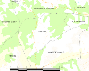
Chalon
- commune in Isère, France
 Hiking in Chalon
Chalon, located in the Isère department of the Auvergne-Rhône-Alpes region in southeastern France, is surrounded by beautiful natural landscapes that offer various hiking opportunities. Here are some highlights of hiking in the area:...
- Country:
- Postal Code: 38122
- Coordinates: 45° 26' 46" N, 4° 55' 53" E
- GPS tracks (wikiloc): [Link]
- Area: 5.2 sq km
- Population: 176
- Web site: [Link]


La Chapelle-de-Surieu
- commune in Isère, France
Hiking in La Chapelle-de-Surieu
La Chapelle-de-Surieu is a charming commune located in the Isère department in the Auvergne-Rhône-Alpes region of southeastern France. It offers a beautiful setting for hiking enthusiasts, with picturesque landscapes, rolling hills, and scenic views of the surrounding mountains....
- Country:
- Postal Code: 38150
- Coordinates: 45° 23' 28" N, 4° 54' 36" E
- GPS tracks (wikiloc): [Link]
- Area: 11.22 sq km
- Population: 752
- Web site: [Link]

Auberives-sur-Varèze
- commune in Isère, France
- Country:
- Postal Code: 38550
- Coordinates: 45° 25' 28" N, 4° 49' 5" E
- GPS tracks (wikiloc): [Link]
- Area: 7.05 sq km
- Population: 1488


Vernioz
- commune in Isère, France
Hiking in Vernioz
Vernioz, located in the Auvergne-Rhône-Alpes region of France, is a charming destination for hikers. Nestled in the foothills of the Massif Central, it offers a scenic landscape with various trails suited for different skill levels and preferences....
- Country:
- Postal Code: 38150
- Coordinates: 45° 25' 19" N, 4° 54' 19" E
- GPS tracks (wikiloc): [Link]
- Area: 11.32 sq km
- Population: 1236
- Web site: [Link]


Saint-Romain-de-Surieu
- commune in Isère, France
Hiking in Saint-Romain-de-Surieu
Saint-Romain-de-Surieu is a picturesque village located in the Auvergne-Rhône-Alpes region of France, nestled in the Isère department. The area is characterized by its beautiful landscapes, rolling hills, and proximity to the French Alps, making it a great destination for hiking enthusiasts. Here are some highlights about hiking in this region:...
- Country:
- Postal Code: 38150
- Coordinates: 45° 23' 11" N, 4° 53' 0" E
- GPS tracks (wikiloc): [Link]
- Area: 4.71 sq km
- Population: 346


Ville-sous-Anjou
- commune in Isère, France
Hiking in Ville-sous-Anjou
Ville-sous-Anjou, located in the Auvergne-Rhône-Alpes region of France, offers a variety of beautiful hiking trails that showcase the natural beauty of the surrounding landscape. While specific trails in Ville-sous-Anjou may not be widely documented, the region is known for its picturesque countryside, rolling hills, and proximity to national parks and natural reserves. Here are some key points to consider when hiking in this area:...
- Country:
- Postal Code: 38150
- Coordinates: 45° 21' 43" N, 4° 51' 49" E
- GPS tracks (wikiloc): [Link]
- Area: 18.25 sq km
- Population: 1203


Cheyssieu
- commune in Isère, France
- Country:
- Postal Code: 38550
- Coordinates: 45° 25' 44" N, 4° 50' 23" E
- GPS tracks (wikiloc): [Link]
- Area: 8.55 sq km
- Population: 1034
- Web site: [Link]

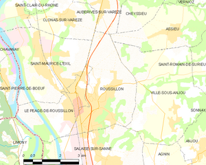
Roussillon
- commune in Isère, France
- Country:
- Postal Code: 38150
- Coordinates: 45° 22' 19" N, 4° 48' 42" E
- GPS tracks (wikiloc): [Link]
- Area: 11.62 sq km
- Population: 8272
- Web site: [Link]


Monsteroux-Milieu
- commune in Isère, France
Hiking in Monsteroux-Milieu
Monsteroux-Milieu, located in the Isère department of the Auvergne-Rhône-Alpes region in France, is a fantastic destination for hiking enthusiasts. The area is known for its stunning natural landscapes, diverse terrain, and a variety of trails suited for different levels of hikers. Here are some key points to know about hiking in Monsteroux-Milieu:...
- Country:
- Postal Code: 38122
- Coordinates: 45° 25' 56" N, 4° 56' 12" E
- GPS tracks (wikiloc): [Link]
- Area: 8.17 sq km
- Population: 785