Verwaltungsgemeinschaft Bad Schandau (Verwaltungsgemeinschaft Bad Schandau)
- management community in the Free State of Saxony, Germany
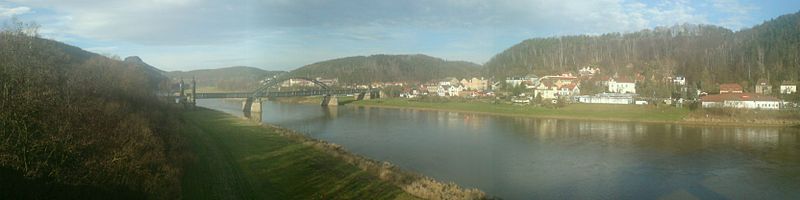
 Hiking in Verwaltungsgemeinschaft Bad Schandau
Verwaltungsgemeinschaft Bad Schandau, located in the Saxon Switzerland region of Germany, is renowned for its stunning natural beauty and excellent hiking opportunities. The area is part of the Saxon Switzerland National Park, which features dramatic sandstone cliffs, deep gorges, lush forests, and stunning views of the Elbe River. Here are some highlights for hiking in this region:
Trails and Routes
-
Bastei Trail: One of the most famous hiking routes, it leads to the iconic Bastei Bridge, offering breathtaking views of the surrounding landscape. The trail is well-marked and suitable for families.
-
Schrammstein Trail: This path takes you through the Schrammsteine rock formations, providing a more challenging experience with some steep ascents. The views from the top are incredibly rewarding.
-
Malta Valley Circuit: A loop that showcases the beauty of the Malta Valley, it's a bit less crowded than some of the other popular trails but equally picturesque.
-
Fernwanderweg: The long-distance hiking trail offers a more extensive trekking experience, connecting various highlights of the Saxon Switzerland region.
Considerations
- Difficulty Levels: Trails in the region range from easy to challenging, so it's important to choose a hike that suits your fitness level.
- Signage: Trails are well-marked, making navigation straightforward. However, a map or GPS can be helpful for more remote paths.
- Seasonal Hiking: Spring and fall are especially beautiful times to visit, with blooming flowers or colorful foliage. Summer can be busy with tourists, while winter offers a quiet, serene landscape.
Safety Tips
- Weather Conditions: Always check the weather before heading out, as conditions can change rapidly.
- Footwear: Wear sturdy hiking boots with good traction, especially on rocky paths.
- Hydration and Snacks: Bring enough water and snacks, particularly if you plan on a longer hike.
- Wildlife Awareness: Be mindful of local wildlife and follow any regulations regarding interactions.
Local Amenities
- Visitor Centers: The area has visitor centers where you can gather information, maps, and advice on current trail conditions.
- Accommodation: There are various options for lodging, from hotels to campsites, depending on your preference.
Whether you’re an experienced hiker or a beginner, Bad Schandau and its surrounding trails offer an excellent way to experience the natural splendor of this unique and beautiful region. Enjoy your hiking adventure!
- Country:

- Coordinates: 50° 55' 0" N, 14° 9' 0" E


- GPS tracks (wikiloc): [Link]
- Wikidata storage: Wikidata: Q8264
Includes regions:

Rathmannsdorf
- municipality in the Saxon district of Sächsische Schweiz-Osterzgebirge, Saxony, Germany
Hiking in Rathmannsdorf
Rathmannsdorf is a charming village located in Germany, particularly known for its picturesque landscapes and proximity to stunning natural areas, making it a great destination for hiking enthusiasts. Here’s what you should know about hiking in Rathmannsdorf:...
- Country:
- Postal Code: 01814
- Local Dialing Code: 035022
- Licence Plate Code: PIR
- Coordinates: 50° 56' 0" N, 14° 8' 0" E
- GPS tracks (wikiloc): [Link]
- AboveSeaLevel: 225 м m
- Area: 4.37 sq km
- Population: 915
- Web site: [Link]


Reinhardtsdorf-Schöna
- municipality in the Sächsische Schweiz-Osterzgebirge, Saxony, Germany
Hiking in Reinhardtsdorf-Schöna
Reinhardtsdorf-Schöna is a beautiful area located near the border of Germany and the Czech Republic, in the Saxon Switzerland National Park. This region is renowned for its picturesque landscapes, rocky formations, and hiking opportunities. Here are some highlights and tips for hiking in Reinhardtsdorf-Schöna:...
- Country:
- Postal Code: 01814
- Local Dialing Code: 035028
- Licence Plate Code: PIR
- Coordinates: 50° 54' 0" N, 14° 12' 0" E
- GPS tracks (wikiloc): [Link]
- AboveSeaLevel: 281 м m
- Area: 31.76 sq km
- Population: 1329
- Web site: [Link]