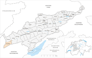
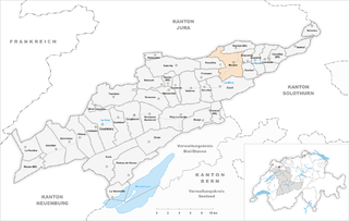
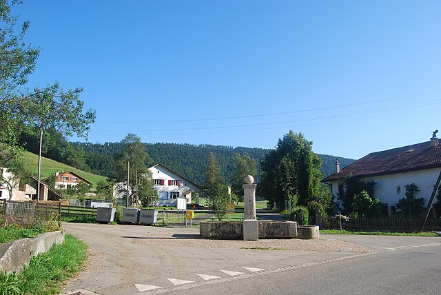
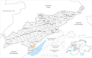
Bernese Jura administrative district (Berner Jura)
- administrative district of the canton of Bern, Switzerland (Verwaltungskreis)
 Hiking in Bernese Jura administrative district
Verwaltungskreis Berner Jura, located in the picturesque region of the Bernese Jura in Switzerland, offers a variety of scenic hiking opportunities. This area is characterized by its rolling hills, lush forests, and stunning views of the surrounding mountains and valleys. Here are some highlights of hiking in this region:
Trails and Routes
-
Hiking Networks: The Berner Jura is known for its well-marked hiking trails. There are numerous routes that cater to different skill levels, from easy walks to more challenging hikes.
-
Scenic Views: Many trails provide breathtaking views of the Jura Mountains and the lowlands. The contrast of the green landscapes with the distant Alpine peaks creates a beautiful backdrop for hikers.
-
Historical Sites: Some trails lead to historical points of interest, including ancient castles, churches, and charming villages that reflect the region's rich heritage.
Recommended Hikes
-
Chasseral: This popular hike takes you to the Chasseral peak, the highest point in the region, offering panoramic views. The route is well-established and provides a moderate challenge.
-
La Vue des Alpes: Starting near La Chaux-de-Fonds, this trail leads you along the ridges with stunning vistas of the Swiss Alps and the surrounding landscape.
-
Local Forest Trails: There are numerous trails that traverse through dense forests, perfect for those looking to connect with nature without venturing too far uphill.
Flora and Fauna
The region is home to diverse plant and animal life, making it ideal for nature enthusiasts. Keep an eye out for various bird species, deer, and other wildlife during your hike.
Tips for Hiking in Verwaltungskreis Berner Jura
-
Weather: Swiss weather can change quickly. Check the forecast before heading out and be prepared for sudden changes in temperature or precipitation.
-
Map and Navigation: While trails are marked, having a physical map or a hiking app can help ensure you stay on the right path, particularly if you venture off the main routes.
-
Supplies: Carry enough water and snacks, especially on longer hikes. Some trails may not have facilities along the way.
-
Respect Nature: Follow Leave No Trace principles to preserve the natural beauty of the area.
-
Local Regulations: Be aware of any local regulations, including designated protected areas for wildlife and restrictions on campfires and other activities.
Hiking in Verwaltungskreis Berner Jura provides a wonderful opportunity to experience the beauty of the Swiss countryside, whether you're seeking an adventurous trek or a leisurely stroll. Enjoy your hike!
- Country:

- Capital: Courtelary
- Licence Plate Code: BE
- Coordinates: 47° 12' 11" N, 7° 13' 1" E


- GPS tracks (wikiloc): [Link]
- Wikidata storage: Wikidata: Q535897
- Wikipedia Commons Category: [Link]
Includes regions:

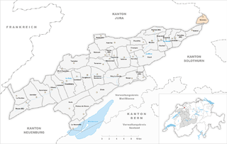
Renan
- municipality in the Jura district of the canton of Bern, Switzerland
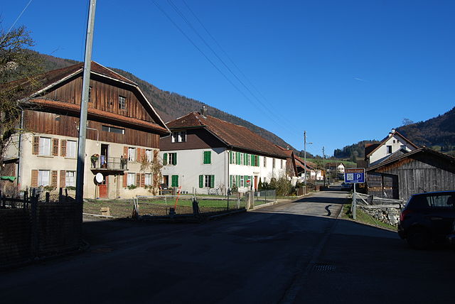
Hiking in Renan
Renan is a charming village located in the canton of Jura in Switzerland. While it's relatively small and might not be as famous as some of the other Swiss hiking destinations, it offers a variety of picturesque trails and natural beauty that makes it an attractive option for hiking enthusiasts....
- Country:
- Postal Code: 2616
- Local Dialing Code: 032
- Licence Plate Code: BE
- Coordinates: 47° 7' 34" N, 6° 55' 33" E
- GPS tracks (wikiloc): [Link]
- AboveSeaLevel: 887 м m
- Area: 12.62 sq km
- Population: 923
- Web site: [Link]


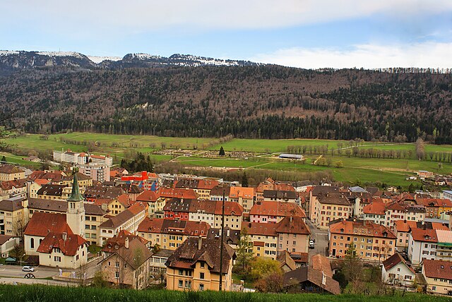
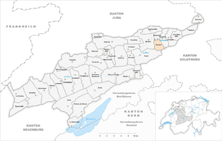
Courtelary
- municipality in Switzerland
Hiking in Courtelary
Hiking in Courtelary, a charming town located in the Bernese Jura region of Switzerland, offers a wonderful experience for outdoor enthusiasts. The area is characterized by its stunning natural scenery, diverse landscapes, and well-marked hiking trails. Here are some highlights to consider when hiking in and around Courtelary:...
- Country:
- Postal Code: 2608
- Local Dialing Code: 032
- Licence Plate Code: BE
- Coordinates: 47° 10' 35" N, 7° 4' 22" E
- GPS tracks (wikiloc): [Link]
- AboveSeaLevel: 699 м m
- Area: 22.24 sq km
- Population: 1391
- Web site: [Link]


Tramelan
- municipality in Switzerland
Hiking in Tramelan
Tramelan is a charming village located in the Jura region of Switzerland, known for its stunning landscapes, rolling hills, and lush forests. It offers a variety of hiking opportunities suitable for all levels of experience. Here are some key points about hiking in Tramelan:...
- Country:
- Postal Code: 2720
- Local Dialing Code: 032
- Licence Plate Code: BE
- Coordinates: 47° 13' 38" N, 7° 5' 48" E
- GPS tracks (wikiloc): [Link]
- AboveSeaLevel: 1053 м m
- Area: 24.88 sq km
- Population: 4595
- Web site: [Link]

Saint-Imier
- municipality in Switzerland
Hiking in Saint-Imier
Saint-Imier, located in the Jura Mountains of Switzerland, is a charming town that serves as a fantastic starting point for various hiking trails. The region is known for its stunning natural landscapes, rich history, and diverse flora and fauna. Here are some highlights and tips for hiking in Saint-Imier:...
- Country:
- Postal Code: 2610
- Local Dialing Code: 032
- Licence Plate Code: BE
- Coordinates: 47° 9' 10" N, 7° 0' 0" E
- GPS tracks (wikiloc): [Link]
- AboveSeaLevel: 892 м m
- Area: 20.89 sq km
- Population: 5156
- Web site: [Link]


Vauffelin
- former municipality of Switzerland
Hiking in Vauffelin
Vauffelin is a charming village located in the canton of Bern, Switzerland, near the scenic region of Lake Biel. While Vauffelin itself is not one of the most well-known hiking destinations, it offers access to beautiful landscapes and walking trails in the surrounding area....
- Country:
- Postal Code: 2537
- Local Dialing Code: 032
- Licence Plate Code: BE
- Coordinates: 47° 11' 14" N, 7° 18' 0" E
- GPS tracks (wikiloc): [Link]
- AboveSeaLevel: 707 м m
- Area: 5.92 sq km
- Web site: [Link]


Cormoret
- municipality in Switzerland
Hiking in Cormoret
Cormoret is a charming village located in the Jura region of Switzerland. It offers a variety of hiking opportunities that cater to different skill levels. Here are some highlights for hiking in the Cormoret area:...
- Country:
- Postal Code: 2612
- Local Dialing Code: 032
- Licence Plate Code: BE
- Coordinates: 47° 10' 23" N, 7° 3' 7" E
- GPS tracks (wikiloc): [Link]
- AboveSeaLevel: 729 м m
- Area: 13.43 sq km
- Population: 486
- Web site: [Link]
Plagne
- municipality in the canton of Bern, Switzerland
Hiking in Plagne
La Plagne is actually located in the French Alps, not Switzerland. It's famous for its winter sports, particularly skiing, but it also offers stunning hiking opportunities during the warmer months. Here's what you can expect when hiking in La Plagne and the surrounding area:...
- Country:
- Postal Code: 2536
- Local Dialing Code: 032
- Licence Plate Code: BE
- Coordinates: 47° 11' 17" N, 7° 17' 13" E
- GPS tracks (wikiloc): [Link]
- AboveSeaLevel: 862 м m
- Area: 7.55 sq km
- Web site: [Link]


Mont-Tramelan
- municipality in Switzerland
Hiking in Mont-Tramelan
Mont-Tramelan is a picturesque mountain located in the Jura region of Switzerland, offering a range of hiking opportunities that cater to various skill levels. Here's what you need to know about hiking in this beautiful area:...
- Country:
- Postal Code: 2723
- Local Dialing Code: 032
- Licence Plate Code: BE
- Coordinates: 47° 12' 40" N, 7° 3' 15" E
- GPS tracks (wikiloc): [Link]
- AboveSeaLevel: 1060 м m
- Area: 4.64 sq km
- Population: 118
Perrefitte
- municipality in Switzerland
Hiking in Perrefitte
Perrefitte is a charming village located in the canton of Bern, Switzerland, offering a variety of options for hikers of all levels. The area is characterized by lush landscapes, rolling hills, and scenic trails that provide both tranquil walks and more challenging hikes....
- Country:
- Postal Code: 2742
- Local Dialing Code: 032
- Licence Plate Code: BE
- Coordinates: 47° 16' 41" N, 7° 19' 9" E
- GPS tracks (wikiloc): [Link]
- AboveSeaLevel: 913 м m
- Area: 8.67 sq km
- Population: 460

Sonvilier
- municipality in Switzerland
Hiking in Sonvilier
Sonvilier is a picturesque village located in the Jura Mountains of Switzerland, offering a range of hiking opportunities for outdoor enthusiasts. The region is characterized by its lush landscapes, rolling hills, and stunning views, making it an appealing destination for hikers of all levels....
- Country:
- Postal Code: 2615
- Local Dialing Code: 032
- Licence Plate Code: BE
- Coordinates: 47° 8' 32" N, 6° 57' 8" E
- GPS tracks (wikiloc): [Link]
- AboveSeaLevel: 1093 м m
- Area: 23.78 sq km
- Population: 1240
- Web site: [Link]


La Heutte
- former municipality of Switzerland
Hiking in La Heutte
La Heutte is a charming destination for hikers, located in the beautiful region of Switzerland. Its serene natural landscapes, including forests, mountains, and rivers, offer a plethora of hiking opportunities for various skill levels....
- Country:
- Postal Code: 2604
- Local Dialing Code: 032
- Licence Plate Code: BE
- Coordinates: 47° 11' 29" N, 7° 13' 40" E
- GPS tracks (wikiloc): [Link]
- AboveSeaLevel: 615 м m
- Area: 8.0 sq km
- Web site: [Link]

Diesse
- former municipality of Switzerland
Hiking in Diesse
Diesse, situated in the Jura Mountains region of Switzerland, offers some fantastic hiking opportunities with stunning landscapes, diverse flora and fauna, and picturesque views of the surrounding mountains and valleys....
- Country:
- Postal Code: 2517
- Local Dialing Code: 032
- Licence Plate Code: BE
- Coordinates: 47° 6' 55" N, 7° 7' 5" E
- GPS tracks (wikiloc): [Link]
- AboveSeaLevel: 838 м m
- Area: 9.44 sq km
- Web site: [Link]


Lamboing
- former municipality of Switzerland
Hiking in Lamboing
Lamboing, located in Switzerland, is known for its picturesque landscapes and offers several hiking opportunities amidst breathtaking scenery. Here are some highlights for hiking in the Lamboing area:...
- Country:
- Postal Code: 2516
- Local Dialing Code: 032
- Licence Plate Code: BE
- Coordinates: 47° 7' 4" N, 7° 8' 10" E
- GPS tracks (wikiloc): [Link]
- AboveSeaLevel: 820 м m
- Area: 9.1 sq km
- Web site: [Link]


Corgémont
- municipality in Switzerland
Hiking in Corgémont
Corgémont is a small but picturesque village located in the Canton of Bern, Switzerland. It's surrounded by beautiful landscapes that make it a great destination for hiking enthusiasts. Here are some aspects to consider when planning your hiking trip in Corgémont:...
- Country:
- Postal Code: 2606
- Local Dialing Code: 032
- Licence Plate Code: BE
- Coordinates: 47° 11' 28" N, 7° 8' 19" E
- GPS tracks (wikiloc): [Link]
- AboveSeaLevel: 664 м m
- Area: 17.6 sq km
- Population: 1668
- Web site: [Link]
Champoz
- municipality in Switzerland
Hiking in Champoz
Champoz is a lesser-known gem for hiking enthusiasts, located in the Jura Mountains of Switzerland. The region is characterized by beautiful landscapes, lush forests, and stunning panoramic views, making it a great destination for hikers of all skill levels. Here are some highlights to consider when planning a hike in Champoz:...
- Country:
- Postal Code: 2735
- Local Dialing Code: 032
- Licence Plate Code: BE
- Coordinates: 47° 15' 30" N, 7° 18' 0" E
- GPS tracks (wikiloc): [Link]
- AboveSeaLevel: 846 м m
- Area: 7.11 sq km
- Population: 168
- Web site: [Link]


Orvin
- municipality in Switzerland
Hiking in Orvin
Orvin is a picturesque village located in the Jura Mountains of Switzerland, an area known for its stunning landscapes and outdoor activities, including hiking. Here are some highlights about hiking in and around Orvin:...
- Country:
- Postal Code: 2534
- Local Dialing Code: 032
- Licence Plate Code: BE
- Coordinates: 47° 9' 38" N, 7° 12' 50" E
- GPS tracks (wikiloc): [Link]
- AboveSeaLevel: 903 м m
- Area: 21.43 sq km
- Population: 1204
- Web site: [Link]


Grandval
- municipality in the canton of Bern, Switzerland
Hiking in Grandval
Grandval is a picturesque region in Switzerland that offers a range of hiking opportunities, surrounded by stunning alpine landscapes. While it may not be as widely known as some other Swiss hiking destinations, it provides a beautiful and serene environment for outdoor enthusiasts. Here are some key points to consider when hiking in the Grandval area:...
- Country:
- Postal Code: 2745
- Local Dialing Code: 032
- Licence Plate Code: BE
- Coordinates: 47° 17' 4" N, 7° 25' 35" E
- GPS tracks (wikiloc): [Link]
- AboveSeaLevel: 602 м m
- Area: 8.24 sq km
- Population: 393
- Web site: [Link]

Moutier
- municipality in Switzerland
Hiking in Moutier
Moutier, located in the Jura region of Switzerland, is a charming town surrounded by beautiful natural landscapes, making it a great destination for hiking enthusiasts. Here are some highlights for hiking in Moutier:...
- Country:
- Postal Code: 2740
- Local Dialing Code: 032
- Licence Plate Code: BE
- Coordinates: 47° 16' 49" N, 7° 22' 15" E
- GPS tracks (wikiloc): [Link]
- AboveSeaLevel: 583 м m
- Area: 19.53 sq km
- Population: 7477
- Web site: [Link]


Tavannes
- municipality in Switzerland
Hiking in Tavannes
Tavannes, located in the Bernese Jura region of Switzerland, offers a variety of hiking opportunities amidst stunning landscapes. Here’s what you need to know about hiking in Tavannes:...
- Country:
- Postal Code: 2710
- Local Dialing Code: 032
- Licence Plate Code: BE
- Coordinates: 47° 13' 15" N, 7° 12' 5" E
- GPS tracks (wikiloc): [Link]
- AboveSeaLevel: 824 м m
- Area: 14.65 sq km
- Population: 3626
- Web site: [Link]
Seehof
- municipality in the canton of Bern, Switzerland
Hiking in Seehof
Seehof, located in Switzerland, offers a beautiful setting for hiking enthusiasts. Nestled near the Lake Zurich area, it's a great place for both short and extended hikes, catering to various skill levels....
- Country:
- Postal Code: 2747
- Local Dialing Code: 032
- Licence Plate Code: BE
- Coordinates: 47° 18' 25" N, 7° 31' 0" E
- GPS tracks (wikiloc): [Link]
- AboveSeaLevel: 752 м m
- Area: 8.42 sq km
- Population: 63


Reconvilier
- municipality in Switzerland
Hiking in Reconvilier
Reconvilier is a picturesque village located in the Jura region of Switzerland, known for its beautiful landscapes and outdoor activities, including hiking. Here are some highlights about hiking in this area:...
- Country:
- Postal Code: 2732
- Local Dialing Code: 032
- Licence Plate Code: BE
- Coordinates: 47° 14' 10" N, 7° 13' 20" E
- GPS tracks (wikiloc): [Link]
- AboveSeaLevel: 799 м m
- Area: 8.23 sq km
- Population: 2308
- Web site: [Link]


Sonceboz-Sombeval
- municipality in Switzerland
Hiking in Sonceboz-Sombeval
Sonceboz-Sombeval is a beautiful area located in the Jura mountains of Switzerland, known for its picturesque landscapes, rich biodiversity, and various hiking trails suitable for all skill levels. Here are some highlights if you're looking to hike in this region:...
- Country:
- Postal Code: 2605
- Local Dialing Code: 032
- Licence Plate Code: BE
- Coordinates: 47° 11' 30" N, 7° 10' 42" E
- GPS tracks (wikiloc): [Link]
- AboveSeaLevel: 669 м m
- Area: 15.03 sq km
- Population: 1944
- Web site: [Link]


Belprahon
- municipality in Switzerland
Hiking in Belprahon
Belprahon is a small village in Switzerland, known for its beautiful natural landscapes and proximity to the Alps, making it an appealing destination for hiking enthusiasts. Here are some key points about hiking in Belprahon:...
- Country:
- Postal Code: 2744
- Local Dialing Code: 032
- Licence Plate Code: BE
- Coordinates: 47° 17' 0" N, 7° 24' 21" E
- GPS tracks (wikiloc): [Link]
- AboveSeaLevel: 610 м m
- Area: 3.79 sq km
- Population: 298
- Web site: [Link]

Schelten
- municipality in Switzerland
Hiking in Schelten
Hiking in Schelten, a picturesque area often associated with natural beauty and outdoor activities, offers a variety of trails suitable for different skill levels. Schelten is known for its scenic landscapes, diverse flora and fauna, and well-maintained paths....
- Country:
- Postal Code: 2827
- Local Dialing Code: 032
- Licence Plate Code: BE
- Coordinates: 47° 19' 51" N, 7° 33' 3" E
- GPS tracks (wikiloc): [Link]
- AboveSeaLevel: 800 м m
- Area: 5.61 sq km
- Population: 34
- Web site: [Link]


Saicourt
- municipality in Switzerland
Hiking in Saicourt
Saicourt, located in the scenic Canton of Bern in Switzerland, offers a rich experience for hiking enthusiasts. The region is known for its stunning landscapes, lush forests, rolling hills, and picturesque views of the surrounding Alps. Here are some details about hiking in Saicourt:...
- Country:
- Postal Code: 2732
- Local Dialing Code: 032
- Licence Plate Code: BE
- Coordinates: 47° 15' 8" N, 7° 10' 29" E
- GPS tracks (wikiloc): [Link]
- AboveSeaLevel: 969 м m
- Area: 13.75 sq km
- Population: 626
- Web site: [Link]


Sornetan
- former municipality of Switzerland
Hiking in Sornetan
Sornetan is a fantastic location for hiking, situated in Switzerland's beautiful Jura region. The area offers a range of trails that cater to different skill levels, making it a great destination for both beginner and experienced hikers....
- Country:
- Postal Code: 2716
- Local Dialing Code: 032
- Licence Plate Code: BE
- Coordinates: 47° 16' 32" N, 7° 13' 0" E
- GPS tracks (wikiloc): [Link]
- AboveSeaLevel: 843 м m
- Area: 5.62 sq km
- Web site: [Link]


Sorvilier
- municipality in Switzerland
Hiking in Sorvilier
Sorvilier is a charming village located in the region of the Bernese Oberland in Switzerland, nestled in the foothills of the Swiss Alps. This picturesque area offers a variety of hiking opportunities that cater to different skill levels, making it a great destination for both novice and experienced hikers....
- Country:
- Postal Code: 2736
- Local Dialing Code: 032
- Licence Plate Code: BE
- Coordinates: 47° 14' 21" N, 7° 18' 13" E
- GPS tracks (wikiloc): [Link]
- AboveSeaLevel: 680 м m
- Area: 7.02 sq km
- Population: 279
- Web site: [Link]


Nods
- municipality in the canton of Bern, Switzerland
Hiking in Nods
Hiking in Nods, Switzerland, offers a unique experience surrounded by picturesque landscapes and a serene atmosphere. Nods is a small village located in the Jura region, known for its rolling hills, dense forests, and beautiful meadows....
- Country:
- Postal Code: 2518
- Local Dialing Code: 032
- Licence Plate Code: BE
- Coordinates: 47° 6' 55" N, 7° 4' 55" E
- GPS tracks (wikiloc): [Link]
- AboveSeaLevel: 885 м m
- Area: 26.7 sq km
- Population: 761
- Web site: [Link]


Malleray
- former municipality of Switzerland
Hiking in Malleray
Malleray is a charming village located in the Bernese Jura region of Switzerland, known for its picturesque landscapes and excellent hiking opportunities. Here are some key points about hiking in and around Malleray:...
- Country:
- Postal Code: 2735
- Local Dialing Code: 032
- Licence Plate Code: BE
- Coordinates: 47° 14' 19" N, 7° 16' 15" E
- GPS tracks (wikiloc): [Link]
- AboveSeaLevel: 699 м m
- Area: 10.35 sq km
- Population: 1903
- Web site: [Link]
Monible
- former municipality of Switzerland
Hiking in Monible
It seems like there may have been a slight misspelling. If you're referring to Monrovia, Liberia, hiking options in that region include exploring nearby lush rainforests and Mount Coffee. Here's an overview:...
- Country:
- Postal Code: 2715
- Local Dialing Code: 032
- Licence Plate Code: BE
- Coordinates: 47° 16' 47" N, 7° 11' 58" E
- GPS tracks (wikiloc): [Link]
- AboveSeaLevel: 824 м m
- Area: 3.39 sq km

Eschert
- municipality in Switzerland
Hiking in Eschert
Eschert, located in the scenic surroundings of the Netherlands, offers a charming experience for hikers looking to explore its lush landscapes and serene environment. While small in size, Eschert is often admired for its picturesque trails and natural beauty....
- Country:
- Postal Code: 2743
- Local Dialing Code: 032
- Licence Plate Code: BE
- Coordinates: 47° 16' 31" N, 7° 24' 5" E
- GPS tracks (wikiloc): [Link]
- AboveSeaLevel: 609 м m
- Area: 6.56 sq km
- Population: 389
- Web site: [Link]


Loveresse
- municipality in Switzerland
Hiking in Loveresse
Loveresse is a small village located in the Jura region of Switzerland, surrounded by beautiful landscapes and nature, making it a great destination for hiking enthusiasts. Here are some key highlights about hiking in and around Loveresse:...
- Country:
- Postal Code: 2732
- Local Dialing Code: 032
- Licence Plate Code: BE
- Coordinates: 47° 14' 27" N, 7° 14' 28" E
- GPS tracks (wikiloc): [Link]
- AboveSeaLevel: 752 м m
- Area: 4.64 sq km
- Population: 325
- Web site: [Link]


Pontenet
- former municipality of Switzerland
Hiking in Pontenet
Pontenet, while not as widely known as some popular hiking destinations, offers some beautiful trails and natural scenery for outdoor enthusiasts. It's essential to consider a few key points when planning a hike in such areas:...
- Country:
- Postal Code: 2733
- Local Dialing Code: 032
- Licence Plate Code: BE
- Coordinates: 47° 14' 36" N, 7° 15' 17" E
- GPS tracks (wikiloc): [Link]
- AboveSeaLevel: 767 м m
- Area: 2.74 sq km
- Web site: [Link]

Corcelles
- municipality in the canton of Bern, Switzerland
Hiking in Corcelles
Corcelles is a charming municipality located in the Canton of Bern, Switzerland. It offers a scenic backdrop for hiking enthusiasts with its rolling hills, lush forests, and beautiful landscapes. Here are some key points about hiking in Corcelles:...
- Country:
- Postal Code: 2747
- Local Dialing Code: 032
- Licence Plate Code: BE
- Coordinates: 47° 17' 10" N, 7° 27' 15" E
- GPS tracks (wikiloc): [Link]
- AboveSeaLevel: 729 м m
- Area: 6.78 sq km
- Population: 201
- Web site: [Link]


Roches
- village and municipality in the Jura, canton of Bern, Switzerland
Hiking in Roches
Roches, located in the region of Valais, Switzerland, is an excellent destination for hiking enthusiasts. The area is known for its stunning alpine landscapes, diverse flora and fauna, and well-marked hiking trails suitable for various skill levels. Here are some highlights and considerations for hiking in Roches:...
- Country:
- Postal Code: 2762
- Local Dialing Code: 032
- Licence Plate Code: BE
- Coordinates: 47° 18' 14" N, 7° 22' 53" E
- GPS tracks (wikiloc): [Link]
- AboveSeaLevel: 585 м m
- Area: 8.97 sq km
- Population: 196


Rebévelier
- municipality in Switzerland
Hiking in Rebévelier
Rebévelier is a picturesque village located in the Jura Mountains of Switzerland. It's an excellent destination for hiking enthusiasts looking for beautiful scenery, tranquil settings, and a variety of trails suitable for different skill levels....
- Country:
- Postal Code: 2717
- Local Dialing Code: 032
- Licence Plate Code: BE
- Coordinates: 47° 17' 35" N, 7° 11' 35" E
- GPS tracks (wikiloc): [Link]
- AboveSeaLevel: 964 м m
- Area: 3.52 sq km
- Population: 42


Crémines
- municipality in Switzerland
Hiking in Crémines
Crémines, located in Switzerland, is a picturesque area that offers a variety of hiking opportunities for outdoor enthusiasts. Nestled in the Bernese Jura, it's known for its stunning natural landscapes, charming villages, and a range of trails suited for different skill levels....
- Country:
- Postal Code: 2746
- Local Dialing Code: 032
- Licence Plate Code: BE
- Coordinates: 47° 17' 0" N, 7° 26' 30" E
- GPS tracks (wikiloc): [Link]
- AboveSeaLevel: 643 м m
- Area: 9.35 sq km
- Population: 519
- Web site: [Link]

Châtelat
- former municipality of Switzerland
Hiking in Châtelat
Châtelat is a lesser-known hiking destination that offers a variety of trails for different skill levels amidst beautiful natural landscapes. While specific trails may not be as widely documented as those in more famous hiking areas, the region is known for its scenic views, diverse flora, and fauna, as well as peaceful, less crowded paths....
- Country:
- Postal Code: 2715
- Local Dialing Code: 032
- Licence Plate Code: BE
- Coordinates: 47° 16' 0" N, 7° 12' 0" E
- GPS tracks (wikiloc): [Link]
- AboveSeaLevel: 802 м m
- Area: 4.09 sq km
- Web site: [Link]


La Neuveville
- municipality in Switzerland
Hiking in La Neuveville
La Neuveville, located on the shores of Lake Biel in Switzerland, is a charming town known for its picturesque landscapes and rich history. Hiking in this region offers stunning views of the lake, the Jura Mountains, and the surrounding vineyards. Here are some highlights and tips for hiking in La Neuveville:...
- Country:
- Postal Code: 2520
- Local Dialing Code: 032
- Licence Plate Code: BE
- Coordinates: 47° 3' 55" N, 7° 5' 40" E
- GPS tracks (wikiloc): [Link]
- AboveSeaLevel: 723 м m
- Area: 6.8 sq km
- Population: 3444
- Web site: [Link]

Prêles
- former municipality of Switzerland
Hiking in Prêles
Prêles is a charming village located in the beautiful region of the Bernese Jura in Switzerland. It offers fantastic opportunities for hiking enthusiasts, with its stunning landscapes, rich flora and fauna, and panoramic views of the surrounding mountains and valleys....
- Country:
- Postal Code: 2515
- Local Dialing Code: 032
- Licence Plate Code: BE
- Coordinates: 47° 6' 0" N, 7° 8' 0" E
- GPS tracks (wikiloc): [Link]
- AboveSeaLevel: 822 м m
- Area: 6.98 sq km
- Web site: [Link]


Souboz
- former municipality of Switzerland
Hiking in Souboz
Souboz is a picturesque village located in the Jura region of Switzerland, known for its stunning landscapes and outdoor activities. Hiking in and around Souboz offers a variety of trails suitable for different skill levels, from easy walks to more challenging hikes that provide breathtaking views of the surrounding mountains and valleys....
- Country:
- Postal Code: 2748
- Local Dialing Code: 032
- Licence Plate Code: BE
- Coordinates: 47° 16' 32" N, 7° 14' 40" E
- GPS tracks (wikiloc): [Link]
- AboveSeaLevel: 917 м m
- Area: 10.63 sq km
La Ferrière
- municipality in the canton of Bern, Switzerland
Hiking in La Ferrière
La Ferrière is a charming village located in the Vaud region of Switzerland, nestled within the scenic Jura Mountains. This area is ideal for hiking enthusiasts, offering a variety of trails that cater to different skill levels, from beginners to seasoned hikers....
- Country:
- Postal Code: 2333
- Local Dialing Code: 032
- Licence Plate Code: BE
- Coordinates: 47° 8' 36" N, 6° 54' 1" E
- GPS tracks (wikiloc): [Link]
- AboveSeaLevel: 1038 м m
- Area: 14.23 sq km
- Population: 542
- Web site: [Link]


Court
- municipality in the canton of Bern, Switzerland
Hiking in Court
Hiking in Court, Switzerland, offers an excellent opportunity to explore the scenic beauty and tranquil nature of the region. While Court may not be as well-known as some of Switzerland's larger towns, it is often surrounded by stunning landscapes that provide ample hiking opportunities....
- Country:
- Postal Code: 2738
- Local Dialing Code: 032
- Licence Plate Code: BE
- Coordinates: 47° 14' 23" N, 7° 21' 33" E
- GPS tracks (wikiloc): [Link]
- AboveSeaLevel: 725 м m
- Area: 24.6 sq km
- Population: 1427
- Web site: [Link]


Saules
- municipality in the canton of Bern, Switzerland
Hiking in Saules
Saules, Switzerland, though not as widely known as some of Switzerland's larger hiking destinations, offers a charming and picturesque setting for outdoor enthusiasts. The region is characterized by stunning alpine landscapes, lush forests, and peaceful valleys that make it an ideal spot for hiking....
- Country:
- Postal Code: 2732
- Local Dialing Code: 032
- Licence Plate Code: BE
- Coordinates: 47° 15' 12" N, 7° 13' 19" E
- GPS tracks (wikiloc): [Link]
- AboveSeaLevel: 1005 м m
- Area: 4.25 sq km
- Population: 153
Bévilard
- former municipality of Switzerland
Hiking in Bévilard
Bévilard is a charming village located in the Jura region of Switzerland, renowned for its beautiful landscapes and diverse hiking opportunities. Here are some key highlights for hiking in Bévilard:...
- Country:
- Postal Code: 2735
- Local Dialing Code: 032
- Licence Plate Code: BE
- Coordinates: 47° 14' 0" N, 7° 17' 0" E
- GPS tracks (wikiloc): [Link]
- AboveSeaLevel: 691 м m
- Area: 5.63 sq km
- Web site: [Link]


Péry
- former municipality of Switzerland
Hiking in Péry
Péry, located in the heart of Switzerland, is a charming village that offers a variety of hiking opportunities framed by stunning natural scenery. Nestled in the Jura Mountains, it provides access to numerous trails that cater to different skill levels, making it suitable for both novice and experienced hikers....
- Country:
- Postal Code: 2603
- Local Dialing Code: 032
- Licence Plate Code: BE
- Coordinates: 47° 12' 0" N, 7° 15' 0" E
- GPS tracks (wikiloc): [Link]
- AboveSeaLevel: 635 м m
- Area: 15.57 sq km
- Web site: [Link]
Cortébert
- municipality in Switzerland
Hiking in Cortébert
Cortébert, a charming small village in Switzerland, is nestled in the scenic Jura Mountains, making it an excellent spot for hiking enthusiasts. The region is known for its picturesque landscapes, lush forests, and well-marked trails that cater to a variety of skill levels....
- Country:
- Postal Code: 2607
- Local Dialing Code: 032
- Licence Plate Code: BE
- Coordinates: 47° 11' 0" N, 7° 6' 0" E
- GPS tracks (wikiloc): [Link]
- AboveSeaLevel: 680 м m
- Area: 14.75 sq km
- Population: 705
- Web site: [Link]


Villeret
- municipality in the canton of Bern, Switzerland
Hiking in Villeret
Villeret, located in the Bernese Jura region of Switzerland, offers a beautiful and peaceful setting for hiking enthusiasts. The region is known for its stunning landscapes, including rolling hills, lush forests, and panoramic views of the Alps....
- Country:
- Postal Code: 2613
- Local Dialing Code: 032
- Licence Plate Code: BE
- Coordinates: 47° 9' 38" N, 7° 1' 16" E
- GPS tracks (wikiloc): [Link]
- AboveSeaLevel: 768 м m
- Area: 16.22 sq km
- Population: 924
- Web site: [Link]
Romont
- municipality in the canton of Bern, Switzerland
Hiking in Romont
Romont, located in the canton of Fribourg, not Bern, is a picturesque town known for its medieval charm and beautiful surrounding landscapes. The area offers a variety of hiking options that cater to different skill levels, from gentle walks to more challenging trails....
- Country:
- Postal Code: 2538
- Local Dialing Code: 032
- Licence Plate Code: BE
- Coordinates: 47° 11' 51" N, 7° 19' 51" E
- GPS tracks (wikiloc): [Link]
- AboveSeaLevel: 919 м m
- Area: 7.07 sq km
- Population: 188
- Web site: [Link]